Difference between revisions of "Sand spit"
Dronkers J (talk | contribs) |
Dronkers J (talk | contribs) |
||
| Line 33: | Line 33: | ||
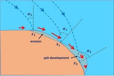
A sand spit develops as a result of littoral drift <math>Q_l</math> (= longshore sediment transport) at a location <math>x_s</math> where the shoreline bends away from the incident waves (Fig. 2). Littoral drift is generated by breaking of obliquely incident waves and follows the direction of the longshore component of the incident waves. In situations with small-moderate incident wave angles, the littoral drift increases at the updrift side until reaching a maximum at <math>x_s</math> on the bending shoreline, while at the downdrift side the littoral driff decreases, as explained below. Sediment will thus accumulate downdrift of the location <math>x_s</math>, initiating the development of a sand spit. | A sand spit develops as a result of littoral drift <math>Q_l</math> (= longshore sediment transport) at a location <math>x_s</math> where the shoreline bends away from the incident waves (Fig. 2). Littoral drift is generated by breaking of obliquely incident waves and follows the direction of the longshore component of the incident waves. In situations with small-moderate incident wave angles, the littoral drift increases at the updrift side until reaching a maximum at <math>x_s</math> on the bending shoreline, while at the downdrift side the littoral driff decreases, as explained below. Sediment will thus accumulate downdrift of the location <math>x_s</math>, initiating the development of a sand spit. | ||
| − | Littoral drift depends on the incident flux of wave energy and on the angle <math>\alpha</math> of the incident waves with the shore-normal direction (Fig. 2). If this angle is small, the longshore transport increases with increasing <math>\alpha</math> approximately as <math>\sin \alpha</math>. However, the amount of wave energy received per unit shoreline length decreases approximately as <math>\cos \alpha</math>. The longshore transport is thus approximately proportional to <math>\cos \alpha \sin \alpha = ½ \sin 2 \alpha</math>. Downdrift of the location <math>x_s</math> where the wave incidence angles become around 45<sup>o</sup> or larger, the longshore sediment transport thus decreases, implying sand accumulation in this zone. | + | Littoral drift depends on the incident flux of wave energy and on the angle <math>\alpha</math> of the incident waves with the shore-normal direction (Fig. 2). If this angle is small, the longshore transport increases with increasing <math>\alpha</math> approximately as <math>\sin \alpha</math>. However, the amount of wave energy received per unit shoreline length decreases approximately as <math>\cos \alpha</math> (the distance along the coast between parallel wave rays with incident angle <math>\alpha</math> is proportional to <math>1/\cos \alpha</math>). The longshore transport is thus approximately proportional to <math>\cos \alpha \sin \alpha = ½ \sin 2 \alpha</math> (see [[Littoral drift and shoreline modelling#Appendix: Derivation of Eq. (2)|explanation]]). Downdrift of the location <math>x_s</math> where the wave incidence angles become around 45<sup>o</sup> or larger, the longshore sediment transport thus decreases, implying sand accumulation in this zone. |
<br clear=all> | <br clear=all> | ||
Revision as of 15:25, 9 May 2023
Definition of Sand spit:
Accretionary feature formed by littoral drift, consisting of a long narrow accumulation of sand or gravel, lying generally in line with the coast, with one end attached to the land and the other projecting into the sea or across the mouth of an estuary or lagoon.
This is the common definition for Sand spit, other definitions can be discussed in the article
|
Description

Sand spits are an ubiquitous feature of sandy coasts with prevailing oblique wave incidence and associated strong littoral drift. Sand spits usually develop where the coastline bends away from the incident waves. The spit follows the longshore direction of the updrift coast. The tip of the spit is typically curved in onshore direction, due to phenomena such as[1][2][3]:
- wave-induced cross-shore sediment transport;
- overwash: sand washed over the spit by overtopping waves and deposited at the leeside;
- incidental changes in the wave incidence direction;
- wave refraction at the distal end of the spit.
Onshore bending of the tip of a sandspit triggers the development of a new protrusion at the distal end[4]; this leads to the often observed finger-shaped spit form.
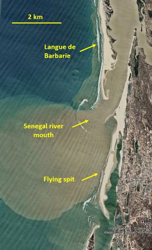
Sand spits can block the river outflow, causing the river mouth to migrate in downdrift direction. A typical example is the "Langue de Barbarie", a sand spit that forces the mouth of the Senegal river several tens of kilometers to the south (Fig. 1). The spit is breached incidentally in situations of exceptional river discharge. After every breach, the sand spit resumes its southward growth of several hundred meters per year[5].
Many back-barrier lagoons with highly variable river inflow experience seasonal closure of the sea outlet by spit growth in summer periods when the streamflow is low, long-period swell waves dominate and longshore transport rates are high[6]. The barrier will be breached at high river discharge. The coastal zone around the lagoon can be flooded before the outlet is fully restored. Lagoon barriers can also be breached during severe storm surges (hurricanes, typhoons) due to erosion by overwashing waves and flow; this will become more common as a result of sea-level rise[7].
Spit development depends crucially on the updrift sand supply. If the updrift sand supply is interrupted or if the sand supply during a long period is smaller than the along-spit sand transport capacity, the spit will breach at an updrift location while the distal end continues to grow[8]. Model experiments suggest that the width of a spit does not only depend on the longshore sand transport, but also on the width of the surf zone[4].
Explanation

A sand spit develops as a result of littoral drift [math]Q_l[/math] (= longshore sediment transport) at a location [math]x_s[/math] where the shoreline bends away from the incident waves (Fig. 2). Littoral drift is generated by breaking of obliquely incident waves and follows the direction of the longshore component of the incident waves. In situations with small-moderate incident wave angles, the littoral drift increases at the updrift side until reaching a maximum at [math]x_s[/math] on the bending shoreline, while at the downdrift side the littoral driff decreases, as explained below. Sediment will thus accumulate downdrift of the location [math]x_s[/math], initiating the development of a sand spit.
Littoral drift depends on the incident flux of wave energy and on the angle [math]\alpha[/math] of the incident waves with the shore-normal direction (Fig. 2). If this angle is small, the longshore transport increases with increasing [math]\alpha[/math] approximately as [math]\sin \alpha[/math]. However, the amount of wave energy received per unit shoreline length decreases approximately as [math]\cos \alpha[/math] (the distance along the coast between parallel wave rays with incident angle [math]\alpha[/math] is proportional to [math]1/\cos \alpha[/math]). The longshore transport is thus approximately proportional to [math]\cos \alpha \sin \alpha = ½ \sin 2 \alpha[/math] (see explanation). Downdrift of the location [math]x_s[/math] where the wave incidence angles become around 45o or larger, the longshore sediment transport thus decreases, implying sand accumulation in this zone.

The initial sand spit development increases locally the curvature of the shoreline. Sand spit development is therefore a continuing, self-reinforcing process (an instability). Very long sand spits may arise in this way. However, in practice they have a finite length, depending on the processes that counteract sand spit growth beyond a certain limit. These processes are:
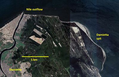
- Cross-shore sediment transport and overwash processes, that bend the sand spit towards the shoreline (Fig. 3).
- Cross-shore currents at river mouths and tidal inlets, that erode the sand spit extremity (Fig. 1).

Sand spits may also develop on a straight shoreline. This can occur in situations of highly oblique waves (wave incidence angle [math]\alpha \gt [/math]45o), as shown in Fig. 4. At the updrift side of a very small initial shoreline bulge, the littoral drift increases (the wave incidence angle [math]\alpha[/math] becomes smaller), whereas at the downdrift side [math]\alpha[/math] increases and the littoral drift decreases. A very small initial bulge will therefore grow. The resulting shoreline protrusion is called a flying spit. It will not continue growing perpendicular to the shore, but it will be bent along the shore by cross-shore sediment transport and overwash processes. In Fig. 1 several examples of flying spits are visible.
Several studies show that simple mathematical models that couple shoreline evolution to longshore sediment transport are capable to simulate the development of flying spits in the way described above[9][10].
A straight shoreline subject to highly oblique wave incidence is inherently unstable, as explained in the article Stability models. Different types of shoreline structures may arise, depending on the type of morphodynamic feedback. Self-organized shoreline structures can also develop at low-angle wave incidence, triggered by other processes, such as wave refraction in the surf zone. Examples are discussed in the article Rhythmic shoreline features.
Related articles
- Littoral drift and shoreline modelling
- Stability models
- Rhythmic shoreline features
- Natural causes of coastal erosion
- Classification of sandy coastlines
- Typical examples of structural erosion
- Sand by-pass systems
References
- ↑ Zenkovich, V.P. 1967. Processes of coastal development. Oliver & Boyd, London. 738 pp.
- ↑ Dan, S., Walstra, D.J.R., Stive, M.J.F. and Panin, N. 2011. Processes controlling the development of a river mouth spit. Marine Geology 280: 116–129
- ↑ Qi, Y., Yu, Q., Gao, S., Li, Z., Fang, X. and Guo, Y. 2021. Morphological evolution of river mouth spits: Wave effects and self-organization patterns. Estuarine, Coastal and Shelf Science 262, 107567
- ↑ 4.0 4.1 Petersen, D., Deigaard, R., Fredsøe, J. 2008. Modelling the morphology of sandy spits. Coastal Engineering 55: 671–684
- ↑ Barusseau, J.P., Ba, M., Descamps, C., Diop, E.H.S., Giresse, P. and Saos, J.L. 1995. Coastal evolution in Senegal and Mauritania at 103, 102 and 101-year scales: natural and human records. Quaternary International 29/30: 61-73
- ↑ Ranasinghe, R. and Pattiaratchi, C. 2003. The seasonal closure of tidal inlets. Coastal Engineering Journal 45: 601-627
- ↑ Nienhuis, J.H., Heijkers, L.G.H. and Ruessink, G. 2021. Barrier breaching versus overwash deposition: Predicting the morphologic impact of storms on coastal barriers. Journal of Geophysical Research: Earth Surface, 126, e2021JF006066
- ↑ Ollerhead, J. and Davidson-Arnott, R.G.D. 1995. The evolution of Buctouch spit, New Brunswick, Canada. Mar. Geol. 124: 215–236
- ↑ Ashton, A. D. and Murray, A. B. 2006. High-angle wave instability and emergent shoreline shapes: 1. Modeling of sand waves, flying spits, and capes. J. Geophys. Res. Earth Surf. 111: 1–19
- ↑ Roelvink, D., Huisman, B., Elghandour, A., Ghonim, M. and Reyns, J. 2020. Efficient Modeling of Complex Sandy Coastal Evolution at Monthly to Century Time Scales. Front. Mar. Sci. 7:535
Please note that others may also have edited the contents of this article.
|