Salt marshes
This article describes the habitat of the salt marshes. It is one of the sub-categories within the section dealing with biodiversity of marine habitats and ecosystems. It gives an overview about the characteristics, distribution, evolution, zonation, succession, biota, threats, functioning and adaptations of the organisms that live in salt marshes.
In 2008 the European Union commissioned a series of Habitat Management Models for several of the more important communities. Included in this was a model for 1330 Atlantic salt meadows (Glauco-Puccinellietalia maritimae).
Visit the European Union web site at [1] to download a copy of the Habitat Management Model for the above community.
Contents
Introduction
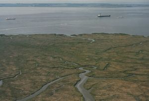
Salt marshes are defined as natural or semi-natural terrestrial halophytic ecosystems. They largely occur in the intertidal zone between land and the sea and are covered by salty or brackish water for at least some of the time. They replace mangroves in temperate and arctic regions. The dominant flora is composed of halophytic plant such as grasses, shrubs and herbs. The flora is rather species poor. The sediment consists of mud and sand. The salt marshes are normally associated with mud flats but also occur on sand flats. These mud flats are sometimes dominated by algae. They are regularly subjected to tidal movement, the height of which can vary from a few centimetres (in enclosed seas such as the Baltic Sea) to several metres in open sea areas such as the Atlantic. The drainage of this seawater is controlled by a meandering network of tidal channels. Through these channels sediments, detritus, dissolved nutrients, plankton and small fishes are flushed in and out the salt marshes.

Distribution
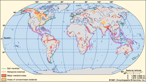
Salt marshes are widely distributed in estuarine systems around the world. They also occur in deltas, rias and on open coasts. Although sediment is a prerequisite for their growth in height and width, salt marsh communities can occur in areas with limited or no sediment supply. Examples include sea water drenched cliffs and slopes on exposed coasts, at the head of sea lochs and rocky beaches (Doody 2008) [2] They have a range from the Arctic region over Europe, Africa, America, Asia to the coast of Australia.
The most extensive development of these salt marshes occurs in estuaries with a large tidal range, abundant fine-grained sediments, sheltered location where particles can settle out of the water column and moderate climate.

Evolution
Salt marshes evolve over time from young marshes to old marshes. The natural young marshes in eastern USA consist for the largest part of low marsh cordgrass Spartina alterniflora. Nutrients are transported by tidal flooding through the tidal channels. This makes it possible for the grasses to grow thickly and abundantly what weakens the effect of waves and tidal currents so the depositional rate of mud increases. Erosion is reduced by the roots and rhizomes of the plants. At the time that the marsh surface builds up above the high water level, the high marsh plants invade, outcompete and replace the low marsh plants. When the quantity of the low and high marshes is equal, the ecosystem is in a mature stage of development. The continued deposition of mud converts most of the low marshes into high marshes. These are called the old marshes. Little water flows through the tidal channels and the marshes are elevated. At this time, streams and rivers deposit sand and mud on these high marshes and convert it into a dry land that is disconnected from ocean influences. [4]
Requirements for development
The requirements for development of salt marshes are:
- They need fine-grained sediments.
- There may be no strong waves or tidal currents.
- They need salty conditions to grow. They are halotolerant and have adaptations to these conditions.
- They need a temperate or cool temperature. Freezing temperatures can occur, but are not damaging the plants.
- They need a wide tidal range. This is important because it limits the erosion, makes deposition of sediments possible and causes a well-marked zonation.
Zonation
Based on the topography and characteristic plant assemblages, salt marshes are classified as low, medium and high marshes and is related to the number of tidal submergences per year (Adam 1990)[5]. Below the low marshes are the tidal creeks. These creeks are channels that are flushed with salty or brackish water. The low marshes extend from the mean low water neap tide to the mean high water spring tide. An example from the eastern shores of the United States of America is dominated by the smooth cordgrass Spartina alterniflora. This grass spreads rapidly. The high marshes extend from the high water tide to the highest spring tide. It is only flooded during extremely high tides and during storms. It resembles more to terrestrial than to a true marine environment. The plant community is more diverse than the low marshes. It consists of Spartina patens, the saltwort grass Salicornia species and the spike grass Distichlis spicata. Distribution, density and activity of invertebrates are mainly controlled by protection, food and frequency of tidal flooding. [6]

Succession
Succession is the serial development of different vegetation types at one place in time. It is a complex process and the factors determining zonation and succession in salt marshes are discussed in some detail in Adam (1990) pages 49-57, Gray (1992) [8] and Packham & Willis (1997) pages 107-114 [9].
The succession starts with unicellular algae such as diatoms sticking the sand together by production of mucus. This causes a brownish biofilm on the substrate.
After this stage, filamentous algae optimize the fixation of sediments. These algae are mostly blue-green algae, Cyanophyta and Chlorophyta. Small gastropods can feed and develop in huge quantities on it. Locally, the filamentous alga Vaucheria can form banquettes or elevations. Brown algae are loosely associated with this stage.
A next stage is the germination of species such as Salicornia. The seeds germinate after some desalination of the soil by rain. Between and around the glassworts takes extra sediment accumulation place. This results in elevating the substrate and makes it more stable. Other species such as Spartina maritima and Spartina anglica compete for the same place. S. maritima is an indigenous species of continental Europe and S. anglica is imported from the British Islands. Note the hybridisation and invasion of "Spartina" spp is a worldwide phenomenon see chapter 9 (Doody 2008).
In Europe, other plants can occur. These herbs are Common Saltmarsh-grass (Puccinellia maritima), Sea Plantain (Plantago maritima), Sea Arrow-grass (Triglochin maritinum), Sea Aster (Aster tripolium), English Scurvy-grass (Cochlearia anglica), Common Sea-lavender (Limonium vulgare), Sea Purslane (Halimione portulacoides), the red alga Bostrychia scorpioides and Catenella caespitosa. [10]. Juncus maritimus is another species that can occur in salt marshes.
Biofilm of unicellular algae [11]
Fixation of the sediment by blue-green and green algae [11]
Salicornia perennis [11]
Spartina townsendii [11]
Triglochin maritinum [11]
Aster tripolium [11]
Limonium vulgare [11]
Functioning and adaptations
Salt marshes have several functions and adaptations to a life in an intertidal ecosystem. They need to conquer some problems to be resistant to the environment. Therefore, it is important to have some adaptations to survive. The first problem is that the plants are freshwater plants. This causes waterstress. For this reason, they have to take up water against the osmotic pressure. To overcome the negative osmotic pressure, they generate a negative hydrostatic pressure (by transpiration processes). They have thin, fleshy leaves and are sensitive to extra stress such as pollution. Anatomically, the plants are adapted through strong lignification, a well-developed epidermis and succulent leaves and stems. Evaporation can be limited by thin leaves with scale-like hairs. Physiologically, plants are adapted by accumulating salt in their tissues. In this way, normal osmosis is possible. Other plants have salt gland cells on the lower surface of the leaves and excrete the salt from its tissue. A second problem is the anoxic environment. The underground in which they root is saturated with water. The tissue of the plants requires oxygen for respiration. Gas diffusion between gas particles can only supply this need in soils that are not waterlogged. Even when the water is saturated with oxygen, its concentration is too low and the diffusion in water is very slow. This is solved by aerenchyma, a tissue that can provide air to the submerged parts of the plants. Roots are superficial systems because of the anoxic sediments. These systems are composed of perennial thick roots with a corky layer and without root hairs. To fixate the substrate, shortliving thin and strongly branched roots with numerous root hairs are developed so they can take up nutrients. Salt marshes have a whole range of functions. It plays an important role as a sediment trap. In this way, it regulates the water quality and helps stabilizing the coastlines. Salt marshes function as filtering systems and retain sediments, excess nutrients, toxic chemicals and disease-causing organisms. They remove nitrates and phosphates from rivers and streams which receive waste water effluents. Another function is the recharge and discharge of groundwater attributing to the water supply. Salt marshes function also as important habitat, nursery grounds for larvae and small organisms, shelter, providing food and a nesting ground for wading birds and other organisms. [12]
Fauna
Small mammals, small fishes, birds, insects, spiders, and marine invertebrates are found in salt marshes. Marine invertebrates include amphipods, isopods, anemones, shrimps, crabs, , turtles, mollusks and gastropods. Fishes such as sticklebacks, silversides, eels and flounders are found in the waters of the salt marshes. The salt marshes are important breeding, feeding and overwintering grounds for waterfowl. These waterfowls consist of ducks, herons, Sharptailed Sparrows, Eurasian Oystercatchers, Reed Bunting,… The benthic community consists of mollusks, polychaeta and oligochaeta. The coastal freshwater marshes are species poor. The organisms that you can find here are water boatmen, flies, mosquitos and snails. Further there are mollusks, ducks, geese, muskrats, raccoons, minks and other small mammals. For some species, a seasonal appearance can be seen. In Saudi Arabia, salt marshes are grazing places for wild dromedaries. [13]
Threats
The total number and area of salt marshes has been declining for many years. The main cause is enclosure, which removes the habitat from tidal inundation. This normally occurs in areas where the level is high enough and the area big enough for embankment to take place. This is usually achieved by the erection of a tidal barrier, sea wall or other structure designed to keep the sea out. This destroys the salt marsh as other uses, notably conversion to intensive agriculture, takes place. Infilling for ports and harbours and other infrastructure completely destroys the habitat and with it any opportunities for restoration. Some areas outside the reclaimed zones can produce new marshes where relative sea level is falling or there is an abundant supply of new sediment and conditions suitable for growth of new plants. [17] With climate change and associated sea level rise this is becoming much less prevalent and the process of 'coastal squeeze' occurs in many areas, especially around the margins of the southern North Sea [18].
Other threats include:
- Over-grazing
- Embankment
- Excessive agricultural use
- Urbanization
- Recreation
- Coastal erosion
- Pollution and industrial waste water
- Invasion of Spartina anglica and Erytrigia (in eutrophic salt marshes)
Case-study: Land van Saeftinghe
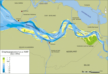
The tidal area ‘Drowned land of Saeftinghe’ (Verdronken land van Saeftinghe) is located at the eastern boundary between the Netherlands and Belgium, a few kilometers downstream Antwerp in the estuary of the Scheldt. It is an official nature reserve since 1976. Because of this legal protection, permits are obligatory for every intervention and strict entrance restrictions are applied. The land is a crosspoint where the river the Scheldt meets the salty water of the North Sea in the estuary known as the Western Scheldt. In the past, the land was a very fertile polder. The area has a surface of 3,484 hectares. Almost 70 % of the area is overgrown by specific plants of the salt marsh. The residual 30 % consists of mud flats, sandbanks and a network of channels. Each tide, the brackish water overflows a large part of the area. The plants there are totally adapted to this and are very unique. For huge quantities of birds, this area is an ideal breeding, rest and wintering place. This makes the area of international importance. Since 1996 it is a special protected area for birds (1979 Directive 79/409/EEC on the conservation of wild birds).

In the past, a few dikes were created to promote the silting up. The northern dike connects a few stands with the dike. These dikes are still recognizable and are used as wandering path. The stands were used as hills where shepherds retreated when the tide became too high.
The flora exists of approximately 50 wild plant species. Algae are not abundant in Saeftinghe because there is too little light that penetrates in the water. Organic matter and a lot of silt make the water turbid. Higher plants are more important in this area. One of the most common plants is pickle weed (Salicornia). But other salt marsh plants such as English Scurvy-grass (Cochlearia anglica) and Common Sea-lavender (Limonium vulgare). [20]
References
- ↑ http://www.marbef.org
- ↑ Doody, J.P. (2008) Saltmarsh Conservation, Management and Restoration. Coastal Systems and Continental Margins, Volume 12, Springer, 217 pp.
- ↑ http://cache.eb.com/eb/image?id=6576&rendTypeId=4
- ↑ Pinet P.R. 1998.Invitation to Oceanography. Jones and Barlett Publishers. p. 508
- ↑ Adam, P., 1990. Saltmarsh Ecology. Cambridge University Press, Cambridge
- ↑ Pinet P.R. 1998.Invitation to Oceanography. Jones and Barlett Publishers. p. 508
- ↑ http://geology.usgs.gov/connections/fws/landscapes/blackwater_model.htm
- ↑ Gray, A.J., 1992. Saltmarsh plant ecology. In: Saltmarshes: morphodynamics, conservation and engineering significance, J.R.L., Allen, & K., Pye, eds., 63-79. Cambridge University Press, Cambridge.
- ↑ Packham, J.R. & Willis, A.J., 1997. Ecology of dunes, saltmarsh and shingle. Chapman & Hall, London.
- ↑ Eric Coppejans – Course Biodiversity of aquatic food webs: from algae to marine mammals UGent
- ↑ 11.0 11.1 11.2 11.3 11.4 11.5 11.6 Eric Coppejans - http://www.vliz.be/imis/imis.php?module=person&persid=134
- ↑ http://wwwutmsi.zo.utexas.edu/staff/dunton/EcoDynamics/MEDLec10.pdf
- ↑ http://museum.gov.ns.ca/mnh/nature/nhns/h2/h2-5.htm
- ↑ http://www.marbef.com - Decleer M.
- ↑ Ross E.S.
- ↑ http://en.wikipedia.org/wiki/Mink
- ↑ Council of Europe – Dijkema K.S. et al. 1984. Salt marshes in Europe. Nature and environment series No.30 p. 178
- ↑ Doody, J.P. (2004) 'Coastal squeeze' - an historical perspective. Journal of Coastal Conservation, 10/1-2, 129-138.
- ↑ http://www.hetzeeuwselandschap.nl/saeftinghe/algemeen/index.php
- ↑ http://www.hetzeeuwselandschap.nl/saeftinghe/index.php
Please note that others may also have edited the contents of this article.
|


