Search results
Create the page "Tidal bore" on this wiki! See also the search results found.
- ...NSW, Australia, a reflective beach. Photo shows the inner surf zone and a bore reaching the swash zone in the background and a swash uprush reaching the t ...he swash zone varies over different timescales, from orders of seconds and tidal periods to years and decades. This is a challenge for coastal scientists, b32 KB (4,942 words) - 12:58, 5 April 2021
- ...periods derived from the various astronomical cycles. The most important tidal components have a periodicity close to semidiurnal or diurnal. ...tidal range: the vertical interval between high and low water levels. The tidal range is commonly classified in three categories: macrotides (ranges exceed27 KB (4,146 words) - 23:36, 19 January 2024
- ..., whereas in the Bay of Fundy, Canada, the shape of the bay augments the [[tidal range]] to over 15m. In Europe, the biggest tides can be found in the Sever ...to as the [[flood]], whereas the falling tide is called the [[ebb]]. The [[tidal currents]] of the ebb and flood play a major part in shaping our coasts, tr10 KB (1,680 words) - 17:24, 28 September 2018
File:TidalBorePetitcodiacRiver.jpg Tidal bore in the Petitcodiac River (Bay of Fundy, Canada)(1,444 × 786 (521 KB)) - 15:41, 29 September 2018
File:SeineBore.jpg Tidal bore in the Seine at Caudebec (1963, springtide).(1,376 × 808 (407 KB)) - 10:41, 1 May 2019
File:TidalBoreKamparRiver.jpg Breaking tidal bore in the Kampar River, Sumatra.(1,195 × 549 (265 KB)) - 19:35, 4 May 2019
File:UndularTidalBoreGaronne.jpg Non-breaking undular tidal bore in the Garonne River.(1,469 × 638 (336 KB)) - 19:41, 4 May 2019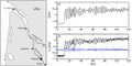
File:ElevationVelocityGaronneTidalBore.jpg ...breaking undular bore in the Garonne River at Podensac, for a large spring tidal range and low river discharge.(1,147 × 572 (124 KB)) - 22:23, 4 May 2019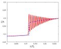
File:UndularBoreModel.jpg Model simulation of an undular tidal bore.(980 × 794 (90 KB)) - 21:11, 5 May 2019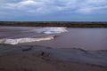
File:PetitcodiacRiver Credit Jim Hoffman.jpg Breaking undular tidal bore in the Petitcodiac River at Moncton, Canada.(1,600 × 1,066 (349 KB)) - 15:18, 6 May 2019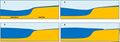
File:TidalBoreFormation TidalFlat.jpg ...ore when the tidal flood wave propagates from a tidal basin into a shallow tidal flat channel.(1,969 × 690 (103 KB)) - 16:42, 25 May 2019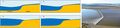
File:TidalFlatBoreFormation-MorecambeBay.jpg ...n of successive stages of tidal bore development on a tidal flat and tidal bore in Morecambe Bay.(2,924 × 690 (241 KB)) - 18:50, 25 May 2019
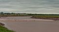
File:SedimentTideBoreSaintMichel.jpg ...ring springtide on a tidal flat in the Baie du Mont Saint Michel and tidal bore photo.(3,696 × 934 (731 KB)) - 19:19, 25 May 2019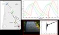
File:GaronneObservationOndularBoreDevelopment.jpg ...on and bore formation in the Gironde-Garonne estuary at spring tide. Tidal bore illustrations at Podensac field site, located 126 km upstream the river mou(1,430 × 846 (177 KB)) - 22:14, 25 May 2019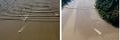
File:GaronneOndularBoreDiffraction.jpg Left image: Undular tidal bore on the Garonne River. Right image: Tidal bore diffraction around an island of the Garonne River.(1,084 × 359 (99 KB)) - 22:16, 25 May 2019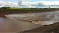
File:PetitcodiacRiver2.jpg Tidal bore in the Petitcodiac River, which is undular at the middle of the channel and(1,514 × 855 (275 KB)) - 22:18, 25 May 2019
File:FlumeUndularBoresDye.jpg Experimental study of tidal-like bore using a laser sheet and fluorescent dye.(1,502 × 191 (30 KB)) - 23:10, 25 May 2019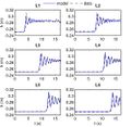
File:UndularBoreDevelopmentModel.jpg ...ghdi simulation. Right image: Serre-Green Naghdi simulation of an undular bore. Comparisons between experimental data and model prediction.(993 × 965 (118 KB)) - 13:54, 16 August 2019
File:PetitcodiacRiver-KamparRiver.jpg ...e channel and breaking near the channel banks. Right image: Breaking tidal bore in the Kampar River, Sumatra.(2,052 × 547 (436 KB)) - 23:39, 25 May 2019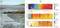
File:TidalBoreSedimentSeeRiver Furgerot.jpg Measurement of sediment transport by a tidal bore in the Sée River on 8 May 2012.(2,004 × 947 (377 KB)) - 13:57, 16 August 2019


