File:RdamWaterwayVelSal.jpg
From Coastal Wiki
Revision as of 12:34, 12 April 2016 by Dronkers J (talk | contribs) (Velocity and salinity distributions in a longitudinal section of Rotterdam Waterway on 9 September 1967 at different tidal phases: at the end of flood tide (H.S.W.=high slack water), during maximum ebb flow, at the end of ebb tide (L.W.S.-low slack wat...)
Size of this preview: 604 × 599 pixels. Other resolutions: 242 × 240 pixels | 746 × 740 pixels.
Original file (746 × 740 pixels, file size: 133 KB, MIME type: image/jpeg)
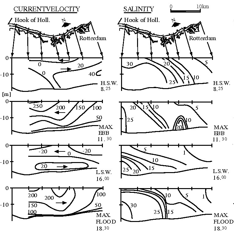
Velocity and salinity distributions in a longitudinal section of Rotterdam Waterway on 9 September 1967 at different tidal phases: at the end of flood tide (H.S.W.=high slack water), during maximum ebb flow, at the end of ebb tide (L.W.S.-low slack water) and during maximum flood flow.
File history
Click on a date/time to view the file as it appeared at that time.
| Date/Time | Thumbnail | Dimensions | User | Comment | |
|---|---|---|---|---|---|
| current | 12:34, 12 April 2016 | | 746 × 740 (133 KB) | Dronkers J (talk | contribs) | Velocity and salinity distributions in a longitudinal section of Rotterdam Waterway on 9 September 1967 at different tidal phases: at the end of flood tide (H.S.W.=high slack water), during maximum ebb flow, at the end of ebb tide (L.W.S.-low slack wat... |
- You cannot overwrite this file.
File usage
The following page links to this file:
