Distribution of Sand Dunes in Great Britain

|
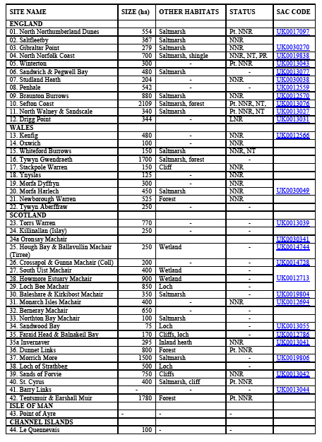
This article will include a distribution map of coastal sand dunes in Great Britain. It lists the more important sites and will provide links to further information on them.
It derives from the 'Sand Dune Inventory of Europe' (Doody 1991) [1]. The 1991 inventory was prepared under the umbrella of the European Union for Dune Conservation [EUDC]. The original inventory was presented to the European Coastal Conservation Conference, held in the Netherlands in November 1991. It attempted to provide an overview of the sand dune resource throughout the whole of Europe including Scandinavia, the Atlantic coast and the Mediterranean.
An overview article on European sand dunes provides links to the other European country reports. These include chapters from updated individual country reports included as part of a revised 'Sand Dune Inventory of Europe' (Doody ed. 1991) prepared for the International Sand Dune Conference “Changing Perspectives in Coastal Dune Management”, held from the 31st March - 3rd April 2008, in Liverpool, UK (Doody ed. 2008)[2].
Sand Dune Distribution in Great Britain
List of important sand dunes .
References
- ↑ Doody, J.P., ed., 1991. Sand Dune Inventory of Europe. Peterborough, Joint Nature Conservation Committee/European Union for Coastal Conservation.
- ↑ Doody, J.P., 2008. Sand Dune Inventory of Europe, 2nd Edition. National Coastal Consultants and EUCC - The Coastal Union, in association with the IGU Coastal Commission.

