Difference between revisions of "File:GSwarmRings.jpg"
From Coastal Wiki
Dronkers J (talk | contribs) (Sea-Surface Temperature showing two warm rings drawing colder shelf water across the shelf edge (black line) on their eastern flanks.) |
Dronkers J (talk | contribs) |
||
| Line 1: | Line 1: | ||
| − | Sea-Surface Temperature showing two warm rings drawing colder shelf water across the shelf edge (black line) on their eastern flanks. | + | Sea-Surface Temperature showing two warm rings drawing colder shelf water across the shelf edge (black line) on their eastern flanks. From http://oceancurrents.rsmas.miami.edu/glossary.html |
Latest revision as of 12:10, 19 May 2017
Sea-Surface Temperature showing two warm rings drawing colder shelf water across the shelf edge (black line) on their eastern flanks. From http://oceancurrents.rsmas.miami.edu/glossary.html
File history
Click on a date/time to view the file as it appeared at that time.
| Date/Time | Thumbnail | Dimensions | User | Comment | |
|---|---|---|---|---|---|
| current | 13:36, 12 November 2016 | 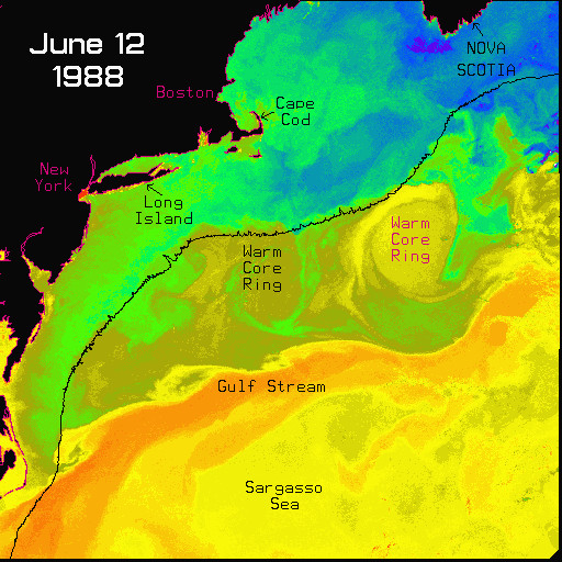 | 512 × 512 (138 KB) | Dronkers J (talk | contribs) | Sea-Surface Temperature showing two warm rings drawing colder shelf water across the shelf edge (black line) on their eastern flanks. |
- You cannot overwrite this file.
File usage
The following page links to this file:
