File:HoChiMinhCityElevation.jpg
From Coastal Wiki
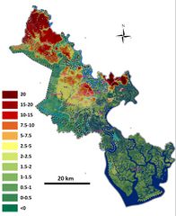
Revision as of 22:01, 9 September 2022 by Dronkers J (talk | contribs) (Elevation map of Ho Chi Minh City, relative to mean sea level. From Tran Thong Nhat, 2014.)

Size of this preview: 489 × 599 pixels. Other resolutions: 196 × 240 pixels | 918 × 1,125 pixels.
Original file (918 × 1,125 pixels, file size: 188 KB, MIME type: image/jpeg)
Summary
Elevation map of Ho Chi Minh City, relative to mean sea level. From Tran Thong Nhat, 2014.
File history
Click on a date/time to view the file as it appeared at that time.
| Date/Time | Thumbnail | Dimensions | User | Comment | |
|---|---|---|---|---|---|
| current | 22:01, 9 September 2022 | | 918 × 1,125 (188 KB) | Dronkers J (talk | contribs) | Elevation map of Ho Chi Minh City, relative to mean sea level. From Tran Thong Nhat, 2014. |
- You cannot overwrite this file.
File usage
The following page links to this file:
