Difference between revisions of "File:Map of the coastal domain and of the local domain .png"
From Coastal Wiki
| (One intermediate revision by the same user not shown) | |||
| Line 1: | Line 1: | ||
| − | + | Map of the coastal domain (a) and of the local domain (b) <br> | |
| + | From Chini, N. and Stansby, P.K. (2012) Extreme values of coastal wave overtopping accounting for climate change and sea level rise. Coastal Engineering, 65, 27-37. | ||
Latest revision as of 15:22, 12 September 2012
Map of the coastal domain (a) and of the local domain (b)
From Chini, N. and Stansby, P.K. (2012) Extreme values of coastal wave overtopping accounting for climate change and sea level rise. Coastal Engineering, 65, 27-37.
File history
Click on a date/time to view the file as it appeared at that time.
| Date/Time | Thumbnail | Dimensions | User | Comment | |
|---|---|---|---|---|---|
| current | 13:47, 12 September 2012 | 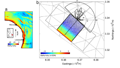 | 414 × 236 (72 KB) | Daphnisd (talk | contribs) |
- You cannot overwrite this file.
File usage
The following page links to this file:
