Difference between revisions of "Fisheries in De Panne"
(→Port description) |
(→Port description) |
||
| Line 18: | Line 18: | ||
De Panne (Geographical coordinates: 51°06'N 2°36'E) is the westernmost Belgian coastal town, which means it shares a border with France. It has a population of almost 10.800 people. The history of De Panne is closely linked with that of Adinkerke, nowadays a small village, situated about 3 kilometres from the sea, that belongs to the municipality of De Panne. The situation used to be reversed however: during the late 18th century, De Panne was part of the larger parish and municipality of Adinkerke <ref name="Gys">[http://www.vliz.be/en/imis?module=ref&refid=225642 Gyselinck, N.; Lanszweert, W.; Steevens, I.; Wolny, M. (2013). Kust- en zeevisserij, in: Steevens, I. et al. (Ed.) (2013). Zeevisserij aan de Vlaamse kust. pp. 114-165.]</ref>. Yet, because of growing importance of coastal tourism from the late 19th century on, De Panne eventually transformed into a larger town than Adinkerke and became independent in 1911 <ref name="geschiedenis">[http://www.depanne.be/product/467/geschiedenis-van-de-panne-en-adinkerke-in-een-notendop Geschiedenis van De Panne en Adinkerke in een notendop], Site Gemeente De Panne.</ref>. Originally though, De Panne was primary a fishing place. It was only founded in 1783, during the time the Austrian branch of the Habsburg monarchy ruled the Southern Netherlands. Emperor Joseph II wanted to stimulate the inshore fisheries and therefore agreed with the proposition of six dignitaries from Veurne to erect a small fishing settlement in the dunes between Adinkerke and Koksijde. Two years after its foundation, the village of De Panne (originally named ‘Josephdorp’ - after Joseph II - and ‘Kerckepanne’) already counted 26 houses <ref name="Gys"/><ref>[http://www.vliz.be/en/imis?module=ref&refid=221639 Bauwens, J. (2012). Ooit droomden Pannese vissers van een 'eigen' haventje!, in: Berquin, H. (Ed.) (2012). In het zand geschreven. De duinen van de Westhoek: een geschiedenis. pp. 193-229.]</ref><ref name="Devent">[http://www.vliz.be/en/imis?module=ref&refid=196194 Devent, G. (1989). De Vlaamse zeevisserij. Marc Van de Wiele: Brugge. ISBN 90-6966-061-X. 208 pp.]</ref>. The fishers used specific vessels, named ‘pannepotten’ or ‘panneschuiten’, which moored on the beach <ref>[http://www.vliz.be/en/imis?module=ref&refid=9606 Desnerck, G.; Desnerck, R. (1976). Vlaamse visserij en vissersvaartuigen: 2. De vaartuigen. Gaston Desnerck: Oostduinkerke. 543 pp.]</ref>. | De Panne (Geographical coordinates: 51°06'N 2°36'E) is the westernmost Belgian coastal town, which means it shares a border with France. It has a population of almost 10.800 people. The history of De Panne is closely linked with that of Adinkerke, nowadays a small village, situated about 3 kilometres from the sea, that belongs to the municipality of De Panne. The situation used to be reversed however: during the late 18th century, De Panne was part of the larger parish and municipality of Adinkerke <ref name="Gys">[http://www.vliz.be/en/imis?module=ref&refid=225642 Gyselinck, N.; Lanszweert, W.; Steevens, I.; Wolny, M. (2013). Kust- en zeevisserij, in: Steevens, I. et al. (Ed.) (2013). Zeevisserij aan de Vlaamse kust. pp. 114-165.]</ref>. Yet, because of growing importance of coastal tourism from the late 19th century on, De Panne eventually transformed into a larger town than Adinkerke and became independent in 1911 <ref name="geschiedenis">[http://www.depanne.be/product/467/geschiedenis-van-de-panne-en-adinkerke-in-een-notendop Geschiedenis van De Panne en Adinkerke in een notendop], Site Gemeente De Panne.</ref>. Originally though, De Panne was primary a fishing place. It was only founded in 1783, during the time the Austrian branch of the Habsburg monarchy ruled the Southern Netherlands. Emperor Joseph II wanted to stimulate the inshore fisheries and therefore agreed with the proposition of six dignitaries from Veurne to erect a small fishing settlement in the dunes between Adinkerke and Koksijde. Two years after its foundation, the village of De Panne (originally named ‘Josephdorp’ - after Joseph II - and ‘Kerckepanne’) already counted 26 houses <ref name="Gys"/><ref>[http://www.vliz.be/en/imis?module=ref&refid=221639 Bauwens, J. (2012). Ooit droomden Pannese vissers van een 'eigen' haventje!, in: Berquin, H. (Ed.) (2012). In het zand geschreven. De duinen van de Westhoek: een geschiedenis. pp. 193-229.]</ref><ref name="Devent">[http://www.vliz.be/en/imis?module=ref&refid=196194 Devent, G. (1989). De Vlaamse zeevisserij. Marc Van de Wiele: Brugge. ISBN 90-6966-061-X. 208 pp.]</ref>. The fishers used specific vessels, named ‘pannepotten’ or ‘panneschuiten’, which moored on the beach <ref>[http://www.vliz.be/en/imis?module=ref&refid=9606 Desnerck, G.; Desnerck, R. (1976). Vlaamse visserij en vissersvaartuigen: 2. De vaartuigen. Gaston Desnerck: Oostduinkerke. 543 pp.]</ref>. | ||
| + | |||
| + | {|style="margin:10px auto" | ||
| + | | [[Image:Fig._1._Duinhoek.jpg|center|480px|]] | ||
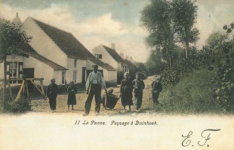
| + | Fig. 1. Typical fishermen’s houses in the settlement of ‘Duinhoek’ in De Panne. Most of these fishers were farmers as well. The houses were built right behind the dunes, where they were sheltered from the wind and hedges and branches protected the fields from the swirling sand <ref name="Devent"/> (Source: [http://www.vliz.be/en/imis?module=ref&refid=80229 Bauwen, L.; Andries, J., 2002]). | ||
| + | | [[Image:Fig._2._pannepot.jpg|center|270px|]] | ||
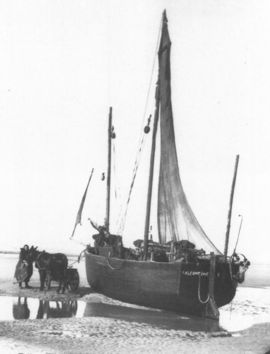
| + | :Fig. 2. Unloading the catch of the ‘pannepot’ Leontine from shipowner Jef Verbanck in 1987. The fisherman’s wife came to collect the catch with donkey and cart (Source: [http://www.vliz.be/en/imis?module=ref&refid=196194 Devent, 1989]). | ||
| + | |} | ||
===<span style="color:#3a75c4; Font-size: 130%">'''<small>References</small>'''</span>=== | ===<span style="color:#3a75c4; Font-size: 130%">'''<small>References</small>'''</span>=== | ||
---- | ---- | ||
<references/> | <references/> | ||
Revision as of 17:27, 25 March 2014
Overview and Background
The Belgian coast is 67 km long and is entirely bordering the province of West-Flanders (region of Flanders, Belgium). The Belgian part of the North Sea is 3,457 km2 (0.5% of the North Sea area), of which more than 1/3 or 1,430 km² are territorial sea within 12 nautical miles distance of the coastline. Belgium currently has 10 coastal municipalities and 4 coastal ports (Nieuwpoort, Oostende, Zeebrugge and Blankenberge), and besides the fish auctions located in Oostende, Zeebrugge and Nieuwpoort where fish is sold according to legal procedures, there are no other dispersed landing points. Although historically the port and auction of Oostende was by far the most important, today the auctions of Zeebrugge (53%) and Oostende (45%) receive the largest share of the landings of Belgian fisheries in Belgian ports.
Belgium has a minor role in the European fisheries context with 0.35% of the total EU production of fish. In 2012, the Belgian commercial sea fishing fleet counted 86 ships, with a total engine capacity of 49,135 kW and gross tonnage of 15,326 GT [1]. 45 vessels are part of the Small Fleet Segment (max 221 kW engine power) of which 2 use passive gear. The remaining 41 vessels belong to the Large Fleet Segment and have an engine power between 221 kW and a maximum of 1,200 kW. This fleet segment represents approximately 80% of the engine power capacity and 77% of the GT of the fleet. While a smaller number use trammel nets (passive gear) and otter trawl, the largest share of the Large Fleet Segment are beam trawl vessels (≥662 kW). The Belgian fleet is highly specialized: more than 68% of the effort(days at sea) and 77% of total landings are achieved by beam trawlers(2010)focusing primarily on flatfish species such as plaice (Pleuronectes platessa) and sole (Solea solea). The results of the reconstruction of the Belgian fleet dynamics since 1830 are presented in Lescrauwaet et al. 2013[2].
The number of days at sea per vessel is fixed at a maximum of 265 per year and in 2011 the entire fleet realized a fishing effort of 15,855 days at sea. In 2011, the Belgian fleet landed a total of 20,138t, of which 16,905t were landed in Belgian ports. Plaice is the most important species in terms of landed weight. The landings of 2011 represented a value of €76.3 million, 14% of which was marketed in foreign ports. Sole generates 47% of the current total value of fisheries in Belgium. The Belgian sea fisheries represent 0.04% of the national Gross Domestic Product [3]. The main fishing grounds in terms of volume of landings in 2010 were in descending order: North Sea South (IVc), Eastern English Channel (VIId), North Sea Central (IVb), Southeast Ireland/Celtic Sea (VIIg) Bristol Channel (VIIf) and Irish Sea (VIIa).
In terms of direct employment, 439 fishers are registered of which approximately 350 are of Belgian nationality. Direct employment in fisheries represent approximately 0.5% of the total employment in the Belgian coastal zone. Another 1040 persons work in the fish processing industry and another 5000 persons in associated trade and services [1]. A historical overview of Belgian sea fisheries is available from [4] and [2].
The Belgian sea fishery sector is rather small compared to that of neighbouring countries in the North Sea and has been gradually losing importance since the Second World War. It is also gradually losing importance relative to the booming tourism industry in the Belgian coastal zone. However fisheries can be an added value to the tourism experience at the coast by developing fisheries-related tourism activities [5].
Port description
De Panne (Geographical coordinates: 51°06'N 2°36'E) is the westernmost Belgian coastal town, which means it shares a border with France. It has a population of almost 10.800 people. The history of De Panne is closely linked with that of Adinkerke, nowadays a small village, situated about 3 kilometres from the sea, that belongs to the municipality of De Panne. The situation used to be reversed however: during the late 18th century, De Panne was part of the larger parish and municipality of Adinkerke [6]. Yet, because of growing importance of coastal tourism from the late 19th century on, De Panne eventually transformed into a larger town than Adinkerke and became independent in 1911 [7]. Originally though, De Panne was primary a fishing place. It was only founded in 1783, during the time the Austrian branch of the Habsburg monarchy ruled the Southern Netherlands. Emperor Joseph II wanted to stimulate the inshore fisheries and therefore agreed with the proposition of six dignitaries from Veurne to erect a small fishing settlement in the dunes between Adinkerke and Koksijde. Two years after its foundation, the village of De Panne (originally named ‘Josephdorp’ - after Joseph II - and ‘Kerckepanne’) already counted 26 houses [6][8][9]. The fishers used specific vessels, named ‘pannepotten’ or ‘panneschuiten’, which moored on the beach [10].
|
Fig. 1. Typical fishermen’s houses in the settlement of ‘Duinhoek’ in De Panne. Most of these fishers were farmers as well. The houses were built right behind the dunes, where they were sheltered from the wind and hedges and branches protected the fields from the swirling sand [9] (Source: Bauwen, L.; Andries, J., 2002). |
|
References
- ↑ 1.0 1.1 Roegiers, B.; Platteau, J.; Van Bogaert, T.; Van Gijseghem, D.; Bekaert, K.; De Bruyne, S.; Delbare, D.; Depestele, J.; Lescrauwaet, A.-K.; Moreau, K.; Polet, H.; Robbens, J.; Vandamme, S.; Van Hoey, G.; Verschueren, B. (2013). VIRA Visserijrapport 2012 Departement Landbouw en Visserij: Brussel. 98 pp.
- ↑ 2.0 2.1 Lescrauwaet, A.-K. (2013). Belgian fisheries: ten decades, seven seas, forty species: Historical time-series to reconstruct landings, catches, fleet and fishing areas from 1900. PhD Thesis. Ghent University (UGent): Gent. xiii, 242 pp.
- ↑ Anon. (2008). Strategische Milieubeoordeling van het Nationaal Operationeel Plan voor de Belgische visserijsector, 2007 - 2013. ILVO Visserij: Oostende. 103 pp.
- ↑ Lescrauwaet, A.-K.; Debergh, H.; Vincx, M.; Mees, J. (2010). Fishing in the past: Historical data on sea fisheries landings in Belgium. Mar. Policy 34(6): 1279-1289. dx.doi.org/10.1016/j.marpol.2010.05.006
- ↑ Anon. (2011). Europees Visserijfonds (EVF). AS 4: ontwikkelingsstrategie voor het Belgisch kustgebied. Europees Visserijfonds: (s.l.). 33 pp.
- ↑ 6.0 6.1 Gyselinck, N.; Lanszweert, W.; Steevens, I.; Wolny, M. (2013). Kust- en zeevisserij, in: Steevens, I. et al. (Ed.) (2013). Zeevisserij aan de Vlaamse kust. pp. 114-165.
- ↑ Geschiedenis van De Panne en Adinkerke in een notendop, Site Gemeente De Panne.
- ↑ Bauwens, J. (2012). Ooit droomden Pannese vissers van een 'eigen' haventje!, in: Berquin, H. (Ed.) (2012). In het zand geschreven. De duinen van de Westhoek: een geschiedenis. pp. 193-229.
- ↑ 9.0 9.1 Devent, G. (1989). De Vlaamse zeevisserij. Marc Van de Wiele: Brugge. ISBN 90-6966-061-X. 208 pp.
- ↑ Desnerck, G.; Desnerck, R. (1976). Vlaamse visserij en vissersvaartuigen: 2. De vaartuigen. Gaston Desnerck: Oostduinkerke. 543 pp.

