File list
This special page shows all uploaded files.
| Date | Name | Thumbnail | Size | Description | Versions |
|---|---|---|---|---|---|
| 14:48, 15 January 2007 | Increasing littoral drift rate.jpg (file) |  |
144 KB | 1 | |
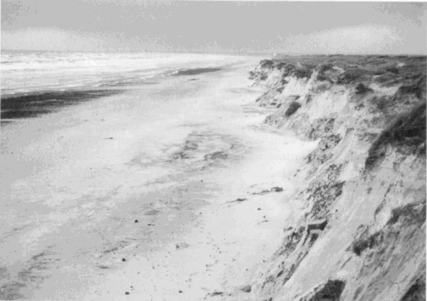
| 12:08, 15 January 2007 | Exposed dune2.jpg (file) |  |
49 KB | 1 | |
| 12:08, 15 January 2007 | Exposed dune1.jpg (file) |  |
58 KB | 1 | |
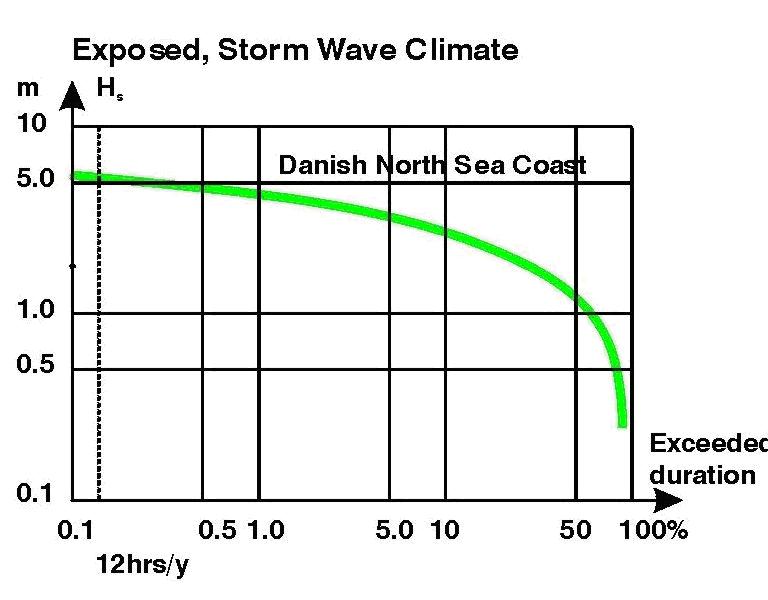
| 11:48, 15 January 2007 | Emperical width.jpg (file) |  |
115 KB | 2 | |
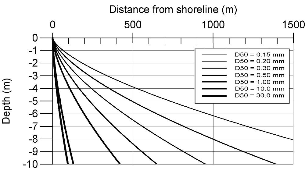
| 11:43, 15 January 2007 | Equilibrium profiles.jpg (file) |  |
76 KB | 1 | |
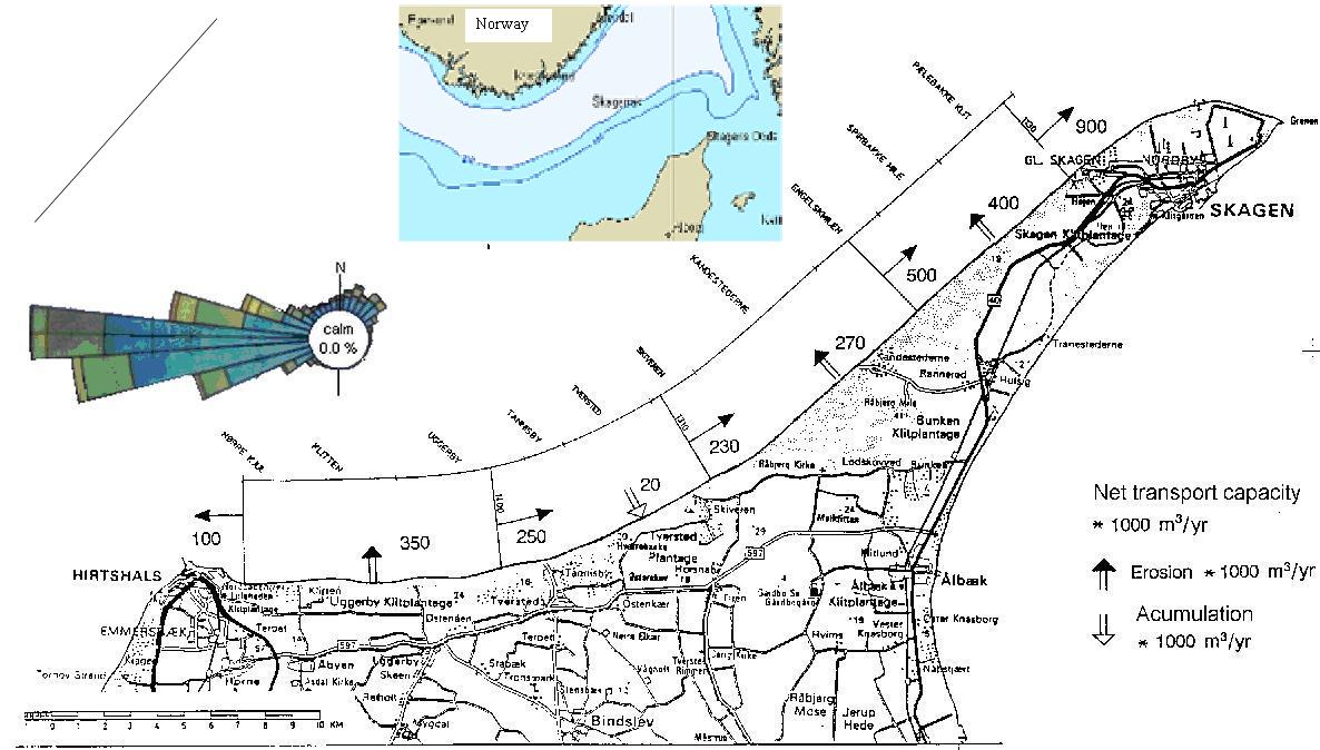
| 11:16, 15 January 2007 | Drift budget.jpg (file) |  |
83 KB | 1 | |
| 16:54, 12 January 2007 | Classification coast.jpg (file) |  |
35 KB | 1 | |
| 16:54, 12 January 2007 | Littoral.jpg (file) |  |
70 KB | 1 | |
| 16:45, 12 January 2007 | Fringing reefRedSea.jpg (file) |  |
40 KB | 1 | |
| 16:44, 12 January 2007 | Monsoon2.jpg (file) |  |
49 KB | 1 | |
| 16:44, 12 January 2007 | Monsoon1.jpg (file) |  |
57 KB | 1 | |
| 16:36, 12 January 2007 | Exposed cliff2.jpg (file) |  |
50 KB | 1 | |
| 16:36, 12 January 2007 | Exposed cliff1.jpg (file) |  |
76 KB | 1 | |
| 16:01, 12 January 2007 | Littoral table.jpg (file) |  |
77 KB | 1 | |
| 16:00, 12 January 2007 | Littoral distribution5.jpg (file) |  |
130 KB | 1 | |
| 16:00, 12 January 2007 | Littoral distribution2.jpg (file) |  |
141 KB | 1 | |
| 12:27, 11 January 2007 | Mangrove coast.jpg (file) |  |
37 KB | 1 | |
| 12:18, 11 January 2007 | Barrier coast.jpg (file) |  |
116 KB | 1 | |
| 12:17, 11 January 2007 | Barrier.jpg (file) |  |
34 KB | 2 | |
| 12:13, 11 January 2007 | Sandy coast.jpg (file) |  |
72 KB | 1 | |
| 12:10, 11 January 2007 | Cohesive sediment.jpg (file) |  |
67 KB | 2 | |
| 12:08, 11 January 2007 | Mud.jpg (file) |  |
31 KB | 1 | |
| 11:04, 9 January 2007 | Sea.jpg (file) |  |
9 KB | 1 | |
| 14:36, 8 January 2007 | CADdrawing.jpg (file) |  |
156 KB | 1 | |
| 14:36, 8 January 2007 | Mike21data.jpg (file) |  |
112 KB | 1 | |
| 14:21, 8 January 2007 | GISCZM3.jpg (file) |  |
43 KB | 1 | |
| 14:20, 8 January 2007 | GISCZM2.jpg (file) |  |
43 KB | 3 | |
| 14:17, 8 January 2007 | Spatialinfo.jpg (file) |  |
47 KB | 1 | |
| 14:10, 8 January 2007 | GISCZM.jpg (file) |  |
76 KB | 1 | |
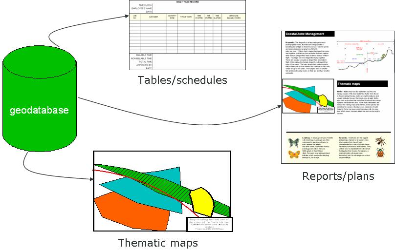
| 14:10, 8 January 2007 | Geodatabase.jpg (file) |  |
52 KB | 1 | |
| 14:10, 8 January 2007 | GISdefinition.jpg (file) |  |
14 KB | 1 | |
| 13:49, 5 January 2007 | Hallo.jpg (file) |  |
4 KB | 1 | |
| 13:10, 5 January 2007 | German Bight.jpg (file) |  |
21 KB | 1 | |
| 13:09, 5 January 2007 | Baltic.jpg (file) |  |
3 KB | 1 | |
| 13:07, 5 January 2007 | Schematic.jpg (file) |  |
84 KB | 1 | |
| 15:08, 3 January 2007 | EutrophicationSchematic.png (file) |  |
99 KB | 1 | |
| 15:05, 3 January 2007 | Seagrass.jpg (file) |  |
9 KB | 2 | |
| 15:10, 2 January 2007 | Cyanobacteria bloom, western Baltic, 1997.JPG (file) |  |
4 KB | 2 | |
| 15:07, 2 January 2007 | Noctiluca miliaris bloom, German Bight, 2000.JPG (file) |  |
21 KB | 1 | |
| 15:02, 2 January 2007 | Eut NEDanishMarineWaters Danish EPA.gif (file) |  |
39 KB | 1 | |
| 14:15, 2 January 2007 | Eutrophication.png (file) |  |
99 KB | 1 | |
| 14:13, 2 January 2007 | US EPA 500px-Eutrophication en svg.png (file) |  |
99 KB | Eutophication schematic | 1 |
| 15:37, 13 December 2006 | ICZM.jpg (file) |  |
28 KB | 1 | |
| 15:34, 13 December 2006 | Measure.jpg (file) |  |
2 KB | 1 | |
| 15:24, 13 December 2006 | Coastfromabove2.jpg (file) |  |
33 KB | 1 | |
| 12:52, 13 December 2006 | Coralreef.jpg (file) |  |
5 KB | 1 | |
| 12:47, 13 December 2006 | Theme 6 coastal.jpg (file) |  |
19 KB | 1 | |
| 12:46, 13 December 2006 | Seabottom2.jpg (file) |  |
12 KB | 1 | |
| 12:46, 13 December 2006 | Seabottom.jpg (file) |  |
9 KB | 1 | |
| 12:41, 13 December 2006 | Dkboat.jpg (file) |  |
6 KB | 1 |