File list
This special page shows all uploaded files.
| Date | Name | Thumbnail | Size | Description | Versions |
|---|---|---|---|---|---|
| 16:02, 17 January 2007 | Nourished beaches equilibrium.jpg (file) |  |
30 KB | 1 | |
| 11:54, 22 March 2007 | 6a. time series offshore waves.jpg (file) |  |
30 KB | 1 | |
| 14:51, 15 January 2007 | Fast ferry waves.jpg (file) |  |
30 KB | 1 | |
| 12:08, 11 January 2007 | Mud.jpg (file) |  |
31 KB | 1 | |
| 15:07, 15 February 2007 | Fig7 sed trans pattern.jpg (file) | 32 KB | 1 | ||
| 11:57, 22 March 2007 | 5 results from morph model calibration.jpg (file) |  |
32 KB | 1 | |
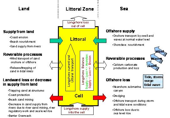
| 16:03, 26 January 2007 | CPandD littoral.jpg (file) |  |
32 KB | 1 | |
| 15:24, 13 December 2006 | Coastfromabove2.jpg (file) |  |
33 KB | 1 | |
| 11:49, 22 March 2007 | 3 bathymetry behind breakwater.jpg (file) |  |
33 KB | 2 | |
| 10:58, 22 March 2007 | 6b. time series offshore waves.png (file) |  |
33 KB | 1 | |
| 18:28, 23 January 2007 | Refraction.jpg (file) |  |
34 KB | 1 | |
| 11:26, 19 February 2007 | Theme01.jpg (file) |  |
34 KB | 1 | |
| 22:23, 27 January 2008 | Sources sinks.jpg (file) |  |
34 KB | 1 | |
| 19:51, 23 January 2007 | Extreme value.jpg (file) |  |
34 KB | 1 | |
| 12:17, 11 January 2007 | Barrier.jpg (file) |  |
34 KB | 2 | |
| 16:54, 12 January 2007 | Classification coast.jpg (file) |  |
35 KB | 1 | |
| 15:02, 15 February 2007 | Fig.jpg (file) |  |
35 KB | 1 | |
| 12:27, 11 January 2007 | Mangrove coast.jpg (file) |  |
37 KB | 1 | |
| 14:48, 15 January 2007 | Overwash.jpg (file) |  |
37 KB | 1 | |
| 15:02, 2 January 2007 | Eut NEDanishMarineWaters Danish EPA.gif (file) |  |
39 KB | 1 | |
| 09:51, 19 February 2007 | Saltmarsh usgs.jpg (file) |  |
39 KB | 1 | |
| 16:45, 12 January 2007 | Fringing reefRedSea.jpg (file) |  |
40 KB | 1 | |
| 22:28, 27 January 2008 | Mass budget A.jpg (file) |  |
40 KB | 1 | |
| 22:28, 27 January 2008 | Mass budget B.jpg (file) |  |
41 KB | 1 | |
| 22:25, 27 January 2008 | N dep atm.jpg (file) |  |
42 KB | 1 | |
| 16:03, 17 January 2007 | Beach drain fn.jpg (file) |  |
42 KB | 1 | |
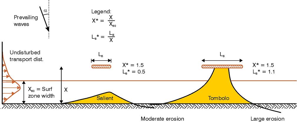
| 15:38, 15 January 2007 | Relation transport angle new.jpg (file) | 42 KB | 1 | ||
| 09:51, 19 February 2007 | Coralreef usgs.jpg (file) |  |
42 KB | 1 | |
| 16:03, 26 January 2007 | Groyne field protection.jpg (file) |  |
43 KB | 1 | |
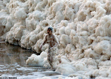
| 02:53, 5 December 2007 | Whipped ocean3.jpg (file) |  |
43 KB | 1 | |
| 14:20, 8 January 2007 | GISCZM2.jpg (file) |  |
43 KB | 3 | |
| 14:21, 8 January 2007 | GISCZM3.jpg (file) |  |
43 KB | 1 | |
| 16:07, 26 January 2007 | Shoreline development mod to very oblique.jpg (file) |  |
44 KB | 1 | |
| 07:00, 19 March 2007 | Crescent correlation new.png (file) |  |
45 KB | 1 | |
| 15:05, 15 February 2007 | Fig2 wave height.jpg (file) |  |
45 KB | 1 | |
| 15:05, 15 February 2007 | Fig3 flexible mesh.jpg (file) |  |
45 KB | 1 | |
| 02:53, 5 December 2007 | Whipped ocean2.jpg (file) |  |
46 KB | 1 | |
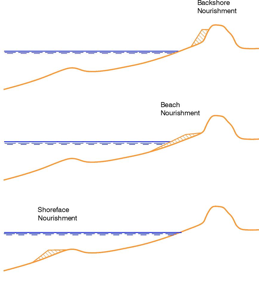
| 16:03, 17 January 2007 | Backshore nourishment.jpg (file) |  |
46 KB | 1 | |
| 14:17, 8 January 2007 | Spatialinfo.jpg (file) |  |
47 KB | 1 | |
| 13:17, 25 January 2007 | Parameter det breakwaters.jpg (file) |  |
48 KB | 1 | |
| 14:51, 15 January 2007 | Sediment overview.jpg (file) |  |
48 KB | 1 | |
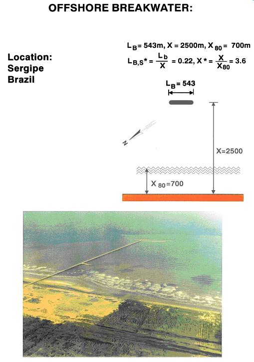
| 13:54, 25 January 2007 | Offshore breakwater.jpg (file) |  |
49 KB | 1 | |
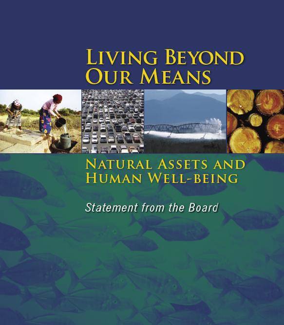
| 14:00, 15 May 2007 | MEA Statement.jpg (file) |  |
49 KB | 2 | |
| 12:08, 15 January 2007 | Exposed dune2.jpg (file) |  |
49 KB | 1 | |
| 16:44, 12 January 2007 | Monsoon2.jpg (file) |  |
49 KB | 1 | |
| 15:41, 15 January 2007 | Initial sed trans new.jpg (file) | 50 KB | 1 | ||
| 14:56, 15 January 2007 | Initial sed trans.jpg (file) | 50 KB | 1 | ||
| 02:49, 17 March 2007 | Refraction.gif (file) |  |
50 KB | 1 | |
| 14:49, 15 January 2007 | Skaw spit.jpg (file) |  |
50 KB | 1 | |
| 07:04, 19 March 2007 | Fast ferry waves.gif (file) |  |
50 KB | 1 |