Difference between revisions of "Template:This weeks featured article"
(Time scales for pollution assessment) |
(Use of Lidar for coastal habitat mapping) |
||
| Line 1: | Line 1: | ||
| − | == | + | ==Use of Lidar for coastal habitat mapping== |
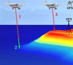
| − | + | [[image:lidar_fig_02.jpg|thumb|250px|left|Figure 1: Sketch of airborne lidar remote sensing and ground GPS]] | |
| − | + | This article describes how Lidar (Laser or Light Detection and Ranging) can be used to collect data about coastal habitats. The article gives an introduction of the measurement principle and also explains how to plan for a Lidar-survey. More information about the conversion of collected [[data]] and the output of Lidar can be found in the article [[Data processing and output of Lidar]]. | |
| + | |||
| + | Lidar (Laser Induced Detection And Ranging ou LIght Detection And Ranging) is an active [[remote sensing]] technique using light emission. Part of the light is diffused or absorbed by the environment and the other part is backscattered in the direction of the source of radiation. The time difference between signal emission and signal reception makes it possible to determine the distance covered since the speed of light is known. Knowing the precise altitude of the aircraft, it is then possible to determine altimetry (or [[bathymetry]]) in each point having received the radiation. | ||
| + | The [[remote sensing]] components of Lidar include: | ||
| + | *a Laser (Light Amplification by Stimulated Emission of Radiation) telemeter also called Laser Scanner, | ||
| + | *a telescope allowing the measurement of backscattered light intensity, and | ||
| + | *acquisition electronics and electro-optical components. | ||
| + | |||
| + | The absolute positioning of the laser scanner (see Figure 2) is ensured thanks to a GPS receiver (Global Positioning System) and an Inertial Navigation System (INS). The GPS System is used in differential kinematics, with one receiver aboard the plane and one or more others stationed at reference points on the ground. The role of the GPS in a GPS/INS integration of the plane's trajectory is to provide the XYZ position, the fastest systems having a frequency of 10Hz. The INS provides the plane altitude at a 100 Hz frequency. The combination of GPS and INS makes it possible to correct the respective defects of each system. Thus, the long-term drift of the inertial platform is corrected by the GPS system's stability. | ||
Revision as of 12:06, 29 September 2008
Use of Lidar for coastal habitat mapping
This article describes how Lidar (Laser or Light Detection and Ranging) can be used to collect data about coastal habitats. The article gives an introduction of the measurement principle and also explains how to plan for a Lidar-survey. More information about the conversion of collected data and the output of Lidar can be found in the article Data processing and output of Lidar.
Lidar (Laser Induced Detection And Ranging ou LIght Detection And Ranging) is an active remote sensing technique using light emission. Part of the light is diffused or absorbed by the environment and the other part is backscattered in the direction of the source of radiation. The time difference between signal emission and signal reception makes it possible to determine the distance covered since the speed of light is known. Knowing the precise altitude of the aircraft, it is then possible to determine altimetry (or bathymetry) in each point having received the radiation. The remote sensing components of Lidar include:
- a Laser (Light Amplification by Stimulated Emission of Radiation) telemeter also called Laser Scanner,
- a telescope allowing the measurement of backscattered light intensity, and
- acquisition electronics and electro-optical components.
The absolute positioning of the laser scanner (see Figure 2) is ensured thanks to a GPS receiver (Global Positioning System) and an Inertial Navigation System (INS). The GPS System is used in differential kinematics, with one receiver aboard the plane and one or more others stationed at reference points on the ground. The role of the GPS in a GPS/INS integration of the plane's trajectory is to provide the XYZ position, the fastest systems having a frequency of 10Hz. The INS provides the plane altitude at a 100 Hz frequency. The combination of GPS and INS makes it possible to correct the respective defects of each system. Thus, the long-term drift of the inertial platform is corrected by the GPS system's stability.
