Groynes as shore protection
This article presents a more detailed treatment of the effects and application of groynes than the article Groynes. The reason for this is not a special preference for groyne solutions but rather because groynes are widely applied shore protection structures and well suited to explain various basic morphological responses including lee side erosion effects. The effect of groynes depends on the type of coast, especially the littoral drift. We distinguish four types of coast (see Classification of sandy coastlines):
- type 1: Perpendicular wave incidence, angle of incidence close to zero, small net littoral drift
- type 2: Nearly perpendicular wave incidence , angle of incidence 1o - 10o, net littoral drift small to moderate
- type 3: Moderate oblique wave incidence , angle of incidence 10o - 50o, large net littoral drift
- type 4: Very oblique wave incidence , angle of incidence 50o - 85o, large net littoral drift
The wave incidence angle is the angle at the breaker line.
Most of the content of this article is drawn from Mangor et al. 2017 [1].
Contents
Method

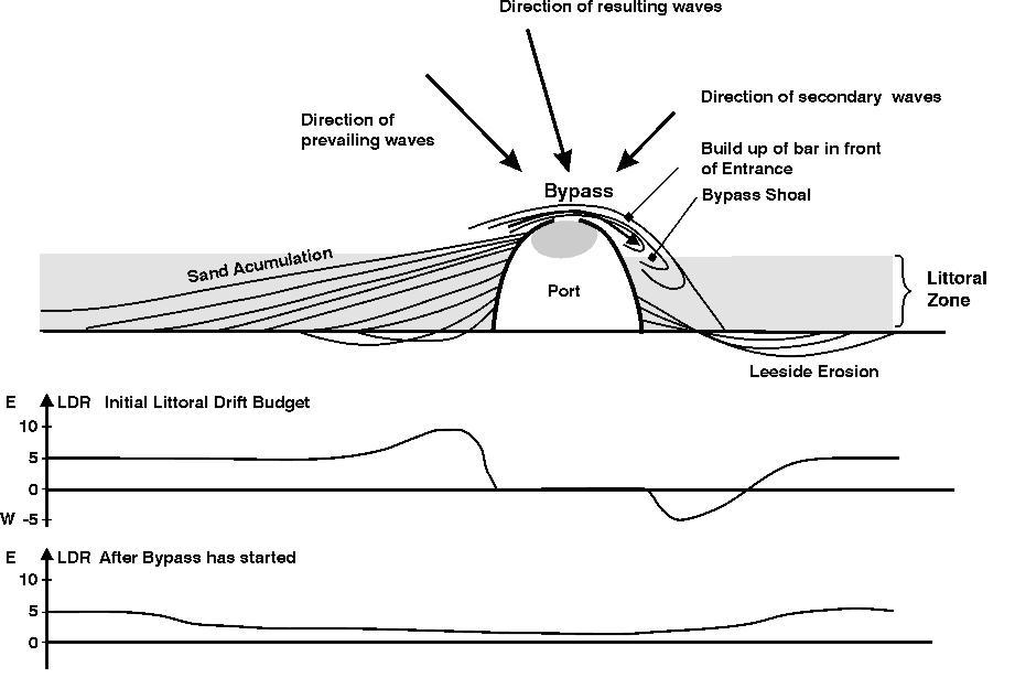
Groynes are normally constructed from the coastline, over the beach and some distance into the shoreface (Fig.1). Their effectiveness in trapping sand from the littoral drift depends on their cross-shore extension or, in other words, how big a part of the littoral drift they block. The sand accumulation and lee side erosion depend on the coastal type and are similar to blocking of the littoral drift by a port, discussed in the article human causes of coastal erosion. However, this comparison is only valid for very long groynes. Groynes are normally designed to cover only part of the surf-zone. For predicting the shoreline response, it is important to know the sediment transport characteristics, as the littoral drift varies greatly over the coastal profile (see Fig.2). Groynes function by trapping sand on the updrift side, and in this way the updrift beach is protected behind the accreted sand sheet. The degree of protection depends on the stability of this sand sheet under extreme conditions. The groyne must, therefore, cover the entire beach, so that it is not back-cut during storm surge and high waves. This means that the landward end of the groyne must be constructed on the coastline at the foot of the cliff/dunes and that its height at the landward end is not lower than the top of the backshore. The height of the groyne further seawards can be lower, depending on the requirements for sediment bypass, etc.
Functional characteristics
Groynes on coast type Nearly perpendicular wave approach

A slightly oblique wave attack and a gradient in the littoral drift are assumed, implying shoreline erosion.
A computer simulation was performed for two types of groynes, a long and a short one (compared to the surf zone width), to demonstrate the effects of single groynes and groyne fields on an eroding shoreline, respectively. The effect of spacing between the groynes in the groyne fields, for the same two types of groynes, was also simulated.
The simulations were performed on an E-W oriented shoreline, which was exposed to prevailing waves from the NW and secondary waves from the NE, resulting in a net littoral drift towards the east. There was also an increasing littoral drift towards the east, which means that the shore was eroding. The direction of the normal to the shoreline with zero net littoral drift was calculated at 350o.
The demonstrations were performed using DHI’s LITPACK software. The module for the calculation of the littoral drift, LITDRIFT, and the one-line shoreline evaluation module, LITLINE, were applied. The coastal profile and distribution of the littoral drift in the coastal profile are presented in the Fig.2. The width of the surf-zone is approximately 400m.
Case 1: Single groyne, short or long

The first shoreline simulation shows the development of the shoreline without any structures, see Fig.3, upper panel. The shoreline is exposed to a uniform shore erosion over the entire stretch.
The second simulation shows the shoreline response for a single groyne with the same length as the width of the surf-zone. The shoreline responds in the same way as in the case of the port in the figure shoreline development around a port, i.e. accretion of a sand sheet with constant orientation on the updrift side. There is also some initial small and local updrift erosion. As sand bypass has not started in the simulation, severe lee side erosion has developed and is continuing to develop.
The third simulation shows the shoreline response for a single, but short groyne. The sand sheet accumulation has stopped at the tip of the groyne but is developing slowly along the updrift shoreline tending towards being parallel to the original shoreline. At the present stage of development, the short groyne actually protects a longer section than the long groyne. This is because the long groyne traps most of the sand close to the structure. The lee side erosion is also large, but the erosion rate is decreasing due to increasing sand bypass.
In both cases, the erosion problem is solved only on the updrift side of the groyne for a length depending on the length of the groyne for the given wave climate. However, lee side erosion is extensive, unavoidable and permanent. Introduction of the groyne has resulted in a drastic response far from the gentle evenly distributed erosion that existed before the intervention.
Case 2: Groyne field, short or long groynes
Fig.3 shows that a single groyne, long or short, causes downdrift erosion on a shoreline exposed to a slightly oblique wave climate. In order to extend the length of the protected area, and to compensate for the lee side erosion, it is common practice to construct several groynes along the shoreline, a so-called groyne field. Fig.4. demonstrates the shoreline development for the following groyne fields:
- three long groynes with a spacing of 600 m, i.e. 1.5 times the length of the groynes.
- three long groynes with spacing equal to 1200 m, i.e. 3 times the length of the groynes.
- three short groynes with a spacing of 600 m
- three short groynes with a spacing of 1200 m

The ability of the groyne field to protect a certain section of a shoreline depends on many parameters discussed in the following.
For the single groyne it was shown that the wave climate and the length of the groyne together determine the length of the section that a single groyne can protect. However, both spacing and time are important parameters for groyne fields, as it takes a relatively long time to fill a groyne field with sand. Until then there will be temporary erosion between the groynes; larger spacing increases the temporary erosion. In the two cases of long groynes, bypass of the first groyne did not start within the simulation time. This means that the only development that takes place between the groynes, is an initial turning of the shoreline to the orientation of zero littoral drift. The erosion downdrift of the groyne field is identical to the erosion caused by the single groyne. However, this will only be the case initially, as bypass has not started in any of the situations. Later, when bypass starts, the erosion will slow down for the single groyne, as shown for the short groyne in Fig.3, whereas major erosion continues in the groyne field, until the two gaps between the groynes have been filled. This means that in the long run a groyne field will give higher lee side erosion than a single groyne.
In the case of the two short groynes, the initial development in the gaps is very similar to the development seen for the long groynes, i.e. a turning of the local shorelines to the direction of zero littoral drift. However, the influence of the bypass can be seen in the first gap, which is gradually being filled with the bypassed material. The lee side erosion for the groyne field is larger than for the single groyne because bypass of the groyne field did not start before the end of the simulation period.
The design of a groyne field requires great care in order to avoid temporary erosion within the field. It must also be remembered, that the protection provided by a groyne field is always at the expense of lee side erosion.

The obvious disadvantages of groynes make that they are used less today than previously. If, for one reason or another, they are used in new protection schemes, artificial sand filling into the groyne system will be a normal part of the project, in order to avoid temporary erosion. Fig.5. shows how one of the groyne fields tested above was filled initially with sand and how this influences the shoreline development. When comparing with shoreline development for the non-filled field (Fig.4 lower panel), it appears that temporary erosion is avoided and that lee-side erosion is slightly smaller.
Other wave climates
The influence of different wave incidence angles has not been demonstrated in the above simulations, but this influence is demonstrated in the following for a shoreline with zero net littoral drift and for a shoreline with a very oblique wave climate, respectively.
Groynes on coast type Perpendicular wave approach
A slightly curved shoreline is assumed, with a perpendicular wave approach at the centre. The natural development of a slightly curved shoreline, with zero net littoral drift in the middle part and with small gradients in the littoral drift away from the middle section, is shown in the upper part of Fig.6. It is seen that there is slight erosion in the middle part of the section despite the fact that the net littoral drift here is zero. The reason is that it is a (negative) nodal point, from which sediment escapes in both directions.
The middle panel of Fig.6. shows the shoreline development in a situation, where the middle section has been isolated by the introduction of two long groynes. The two groynes practically secure the middle section of the shoreline against erosion by preventing loss of sand to the adjacent sections. In this situation the erosion a small distance away from the groynes is slightly larger than the erosion in the situation without groynes; the reason is that the two groynes trap sand and prevent loss from the middle section. This trapped and non-eroded sand is consequently missing along the adjacent sections.
The lower panel of Fig.6 shows the shoreline development for one long groyne located at the point of zero net littoral drift. The groyne causes local accumulation on both sides close to the groyne and erosion at adjacent sections, which is a little larger than the erosion without a groyne.
Groynes on coast type Moderate - very oblique wave approach

An eroding shoreline is assumed, with moderate oblique to very oblique wave incidence. The upper part of Fig.7 demonstrates the natural shoreline development for a shoreline exposed to oblique wave incidence, with increasing littoral drift in the direction of the net drift. As a result, the shore is exposed to uniform erosion along the entire section.
The long groyne develops at first only a relatively short updrift sand sheet, and there is also an updrift erosion area, which is just slowly filled in. A relatively long stretch of downdrift coastline is exposed to severe erosion. When sand bypass starts, sand will be deposited in a shoal east of the groyne head, which means that it will not contribute to the littoral drift budget for the downdrift shoreline. This assumption will be correct for the first (many) years, see the discussion in the article on Groynes and similar structures perpendicular to the shore. The same phenomenon is shown in the article Accretion and erosion for different coastal types, where the influence of a port in a similar wave climate was discussed. In the situation discussed here the only positive influence of the groyne is a short sand sheet updrift of the groyne over a length comparable to the length of the groyne itself, whereas the erosion downdrift has increased considerably compared to the situation without protection. It appears that the protected section is considerably shorter than the protected section for the slightly oblique wave climate as presented in Fig. 3.
Discussion of 2- and 3-D effects and long-term profile changes
The above shoreline developments for various groyne schemes are somewhat simplified as they do not include 2-D or 3-D effects or long-term profile changes. Such effects do, however, occur in connection with groyne schemes.
2-D effect
A groyne redirects the longshore current, as it is constructed perpendicular into the longshore current. The groyne thus directs the current seawards along the structure, whereby an offshore-directed jet is generated. A long groyne approximately the same length as the width of the surf-zone, will generate a strong jet as the entire longshore current is blocked. A shorter groyne will generate a smaller jet more or less parallel to the shore due to the interference with the outer uninterrupted part of the longshore current. Under all circumstances, the jets will cause loss of sand to deeper water. Offshore directed sediment forms lobate deposition zones downdrift of the tips of the structures[2].
The contraction of the current near the head of the groyne will also cause local seabed erosion updrift and off the groyne head, which may damage the head.
In the lee zone of the groyne, wave diffraction and the decrease in wave set-up on the foreshore towards the structure (for an explanation see Shallow-water wave theory), will generate an eddy with the outward-directed current running along the lee side of the structure. This eddy adds to the offshore sand loss and local seabed erosion and it is also dangerous for swimmers during rough weather.
3-D effect
When waves and current pass the breakwater head, 3-D current eddies will be formed, which will generate scour in the seabed in addition to the local seabed erosion caused by the 2-D current contraction. The scour is especially pronounced for structures that cause abrupt current changes.
Long-term erosion in the coastal profile
A groyne field constructed at an eroding shoreline, not covering the entire width of the littoral zone, will only protect the inner part of the coastal profile against erosion. The outer part of the coastal profile will continue to erode and the coastal profile will gradually become steeper. This will destabilise the outer part of the groynes ; the groyne heads will eventually collapse unless they are regularly reinforced. A groyne field, which covers the entire littoral zone, will not be exposed to this phenomenon, but groynes are seldom built that long.
Applicability
Although groynes may protect some shoreline sections, it is obvious from the above that groynes have many disadvantages. Furthermore, it appears that the effectiveness of groynes depends on the type of coast. The applicability of groynes on different types of coasts is discussed below, where advantages and disadvantages are highlighted
Coast type Perpendicular wave approach
Groyne fields can be used on type 1 coasts in order to prevent loss of sand into adjacent sections. As there is no net littoral drift in this situation, only local sand is trapped close to the groyne, and hardly any lee side erosion occurs. However, minor additional erosion does occur in neighbouring sections due to the lack of the supply of sand from the protected section.
Coast type Nearly perpendicular wave approach
Groynes are applicable on coasts (or on coastal sections) with a small angle of wave incidence. The groynes accumulate sand on their updrift side at the expense of lee side erosion on the downdrift side. Groyne fields will be exposed to initial erosion inside the protected area if they are not nourished as part of the construction scheme. Local erosion and scour will occur near the groyne heads, and the outer part of the coastal profile will continue to erode. Groynes will eventually collapse if their heads are not reinforced.
The negative effects of the groyne fields, lee side erosion and profile steepening, can be mitigated by regular nourishment. The advantage of the combined solution of groyne fields and nourishment is that well-designed groynes prevent or mitigate erosion of the beach. However, groynes are less effective during extreme events; in such situations they only slow down the rate of coastal erosion caused by offshore movement of the sand. So, groynes and nourishment are not sufficient coastal protection in themselves, especially if buildings are constructed near the dune foot or the cliff edge.
Coast type Moderate - very oblique wave approach
As the accreted updrift sand sheet for these types of coasts is very short, groynes cannot be recommended as a protective measure. This also holds for coasts with nearly shore-parallel wave incidence. In addition, groynes on coasts with a high wave incidence angle may lead to the development of a sand spit off-set from the coastline (sometimes called 'flying spit'). This will deprive the downdrift shoreline of sediment supply. In the shelter of the sand spit an unwanted lagoon may develop. Groynes on these types of shorelines may start an uncontrollable development.
General comments
- Groynes tend to trap seaweed and floating debris on the updrift side as well as on the lee side.
- Groynes obstruct passage along the beach.
- Groynes are often dangerous to walk on; however, if they are built to allow passage on the top, they are popular for promenade and fishing.
- The lee zone eddy as well as the updrift rip current can be dangerous for bathers.
- Groynes constitute a foreign element in the coastal landscape due to their unnatural shape being perpendicular to the shoreline.
Related articles
- Groynes
- Deteriorated groynes
- Human causes of coastal erosion
- Natural causes of coastal erosion
- Accretion and erosion for different coastal types
- Shallow-water wave theory
- Classification of sandy coastlines
- Littoral drift and shoreline modelling
- Coastal Hydrodynamics And Transport Processes
- Hard coastal protection structures
- Port breakwaters and coastal erosion
- Dealing with coastal erosion
- Stability of rubble mound breakwaters and shore revetments
References
- ↑ Mangor, K., Drønen, N. K., Kaergaard, K.H. and Kristensen, N.E. 2017. Shoreline management guidelines. DHI https://www.dhigroup.com/marine-water/ebook-shoreline-management-guidelines
- ↑ Nordstrom, K.F. 2014. Living with shore protection structures: A review. Estuarine, Coastal and Shelf Science 150: 11-23
Please note that others may also have edited the contents of this article.
|