Difference between revisions of "Spatial and temporal scales in biogeomorphology"
Dronkers J (talk | contribs) (Created page with " Different physical and biological processes can have dynamic interactions when they operate on the same '''spatial and temporal scales'''. In this article the spatial and tem...") |
Dronkers J (talk | contribs) |
||
| Line 36: | Line 36: | ||
| − | |||
| − | |||
| − | |||
[[Category:Geomorphological processes and natural coastal features]] | [[Category:Geomorphological processes and natural coastal features]] | ||
[[Category:Hydrological processes and water]] | [[Category:Hydrological processes and water]] | ||
Revision as of 19:59, 19 February 2019
Different physical and biological processes can have dynamic interactions when they operate on the same spatial and temporal scales. In this article the spatial and temporal scales are defined for estuaries by looking at the interactions between several factors that lead to variations in the stability and morphology of fine intertidal sediment shores. The coupling of mudflats to salt marshes is also discussed.
Contents
Scale interactions in biogeomorphology
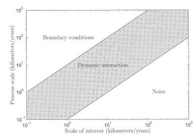
Different physical and biological processes can have dynamic interactions when they operate on the same spatial and temporal scales. Processes that act on a very small scale may appear as noise in the interactions with processes on larger scales. Their effect can be accounted for by proper averaging procedures (e.g. for turbulence). Processes that act on a large scale may be treated as slowly varying or even constant boundary conditions when studying their effects on processes on smaller scales (e.g. sea level rise due to climate change). Techniques for scale interactions are reasonably well established in geomorphology (De Vriend, 1991)[1] and are based on scale linkage via sediment transport. In biology however, population and community dynamics give rise to spatial and temporal structures that are not easily linked. In recent years the importance of scale has been increasingly recognized (Legendre et al., 1997)[2] as an essential aspect of understanding the biotic and abiotic processes that affect the biogeomorphology of coastal systems.

Spatial and temporal scales defined for estuaries
There are marked spatial and temporal variations in the stability and morphology of the intertidal fine sediment shores in estuaries and embayments of NW Europe. This is due to the interactions between several factors:
- The spatial distribution of biota acting as ecosystem engineers in relation to intertidal height and the estuarine salinity gradient,
- The seasonal and inter-annual changes in these biota and particularly the relative abundance of bio-stabilisers and -destabilisers,
- Physical drivers determining biota abundance (e.g. temperature, salinity), and
- The frequency and intensity of erosive forces (e.g. wind-wave activity, storms, rainfall and fluvial flow).
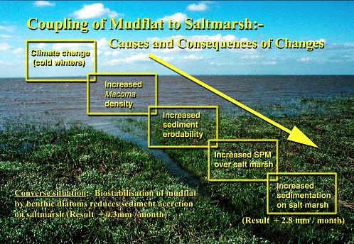
For example, field studies in the Humber (England) and Westerschelde (Netherlands) have shown significant temporal-spatial changes in intertidal sediment erodability and morphology which reflects the interaction between physical processes of erosion (tidal currents and waves) and the abundance of biological stabilisers (benthic diatoms) and destabilisers (the clam Macoma balthica). Following cold winters there is an increase in the density of the bioturbating clam which causes an increase in intertidal sediment erodability. Current and wave induced erosion of the mudflat, elevates suspended sediment concentrations which are then transported up the shore on the flood tide and onto the salt marsh where there is enhanced sediment accretion. Conversely, when clam densities are low and grazing pressure low (usually following a series of mild winters), there is enhanced stabilisation of the mudflat by benthic diatoms which leads to a reduction in sediment resuspension into the water column and an order of magnitude lower rate of accretion on the salt marsh. This provides an interesting parallel between man’s stabilizing influence on long-shore sediment transport (i.e. use of groynes), and biota’s influence on up-shore sediment transport. Namely, stabilising sediment in one area is likely to reduce transport and accretion in another area.
Coupling of mudflat to Saltmarsh
Research suggests that predicted climate change (i.e. global warming with associated sea level rise) is likely to induce a shift towards increased bio-stabilisation of intertidal sediments (micro-organisms and macroalgae) and as a consequence reduce sediment accretion on salt marshes[3]. However, climate models also predict increases in the frequency and intensity of storms, but at present it is unknown whether this will result in net erosion or net accretion on upper shore salt marshes. Both situations have been recorded and the net result may be dependent on various factors including the sediment supply and grain size, the shore profile, and the orientation of salt marsh relative to prevailing winds.
See also
References
- ↑ 1.0 1.1 De Vriend H.J., 1991. Mathematical modelling and large-scale coastal behaviour, Part 1: Physical processes. Journal of Hydraulic REsearch 29, pp. 727-740
- ↑ Legendre, P., S.F. Thrush, V.J. Cummings, P.K. Dayton, J. Grant, J.E. Hewitt, A.H. Hines, B.H. McArdle, R.D. Pridmore, D.C. Schneider, S.J. Turner, R.B. Whitlatch & M.R. Wilkinson, 1997. Spatial structure of bivalves in a sand flat: Scale and generating processes. Journal of Experimental Marine Biology and Ecology, 216, pp. 99-128.
- ↑ Reed, D.J., Davidson-Arnott, R. and Perillo, G.M.E. 2012. Estuaries, coastal marshes, tidal flats and coastal dunes. In: Geomorphology and Global Environmental Change (eds. O. Slaymaker, T. Spencer and C. Embleton-Hamann). Cambridge Univ. Press.
Please note that others may also have edited the contents of this article.
|
