Difference between revisions of "Template:This weeks featured article"
From Coastal Wiki
(→Waves) |
(Human activities and nature conservation conflicts at the Kenyan coastline) |
||
| Line 1: | Line 1: | ||
| − | == | + | ==Human activities and nature conservation conflicts at the Kenyan coastline== |
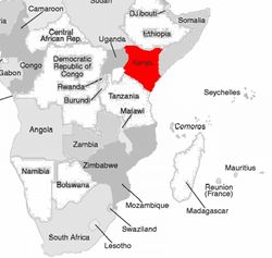
| − | [[Image: | + | [[Image:kenya_fig1.jpg|thumb|250px|left|Figure 1: Map of SE Africa.]] |
| − | |||
| − | + | The Kenyan coastline is approximately 500 km long, with a well developed fringing reef system except where major rivers (Tana and Athi Sabaki) discharge into the Indian Ocean (Hamilton and Brakel, 1984).The coastal zone environment and its resources in the western Indian Ocean(WIO) region countries: Kenya, Tanzania, Mozambique, Seychelles, Mauritius and Comoros play an important role in the economy of the people. | |
| + | |||
| + | Population growth, loss of social and community identity, lack of resources, hunger and poverty are the central problems of Kenyan coastal area. The development process has meant that effective and sustainable management is no longer feasible, despite the availability of resources. | ||
Revision as of 10:25, 13 October 2008
Human activities and nature conservation conflicts at the Kenyan coastline
The Kenyan coastline is approximately 500 km long, with a well developed fringing reef system except where major rivers (Tana and Athi Sabaki) discharge into the Indian Ocean (Hamilton and Brakel, 1984).The coastal zone environment and its resources in the western Indian Ocean(WIO) region countries: Kenya, Tanzania, Mozambique, Seychelles, Mauritius and Comoros play an important role in the economy of the people.
Population growth, loss of social and community identity, lack of resources, hunger and poverty are the central problems of Kenyan coastal area. The development process has meant that effective and sustainable management is no longer feasible, despite the availability of resources.
