WiSAR - Wind retrieval from synthetic aperture radar
Introduction
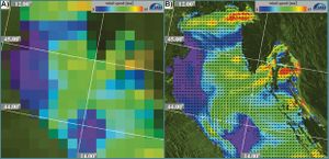
Today, several scatterometers (SCATs) are available that measure ocean surface wind fields with a resolution of up to 25 km on a global and operational basis. Originally they were not designed to observe also samll-scale wind features, which are especially important in coastal areas. However, satellite-borne synthetic aperture radars (SARs) offer this unique opportunity, as they image the ocean surface with a much higher resolution than SCATs, typically below 100 m (Fig. 1). Several SARs have been launched in the last 12 years and are valuable tools for measuring geophysical parameters such as ocean surface winds, waves, and sea ice.
SAR wind retrieval
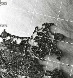
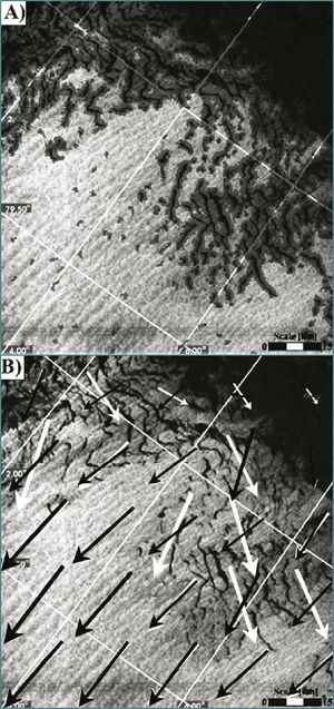
The retrieval of ocean surface wind from SAR is a two-step process; in the first step, wind directions are retrieved, which are a necessary input in the second step. Wind directions are extracted from wind-induced streaks, which are aligned with wind direction and which are visible in the SAR image (Fig. 2). Orientations of these streaks are extracted by using the Local Gradient (LG) Method (Horstmann et al., 2002 [1], Koch, 2004[2]). In the second step wind speeds are retrieved from the backscattered normalized radar cross section (NRCS) of the ocean surface by utilizing a geophysical model function (GMF). The GMF describes the dependence of the NRCS on the wind and radar imaging geometry (Horstmann and Koch, 2005[3]).
Validation
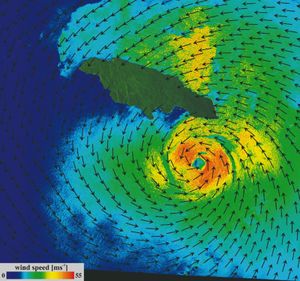
Several comparisons of SAR retrieved wind fields with results from numerical weather prediction models at wind speeds below 25 ms-1 have shown that WiSAR is capable of retrieving winds with a typical error of ~20° in wind direction and ~2 ms-1 in wind speed (Horstmann et al., 2003[5]; Horstmann and Koch, 2005[3]; Koch and Feser, 2006[6]). It has also been shown that it is possible to retrieve wind fields under extreme high wind situations (Horstmann et al. 2005[7]). Fig. 4 shows an example of a WiSAR retrieved wind field of hurricane Ivan (10. September 2004). However, recent studies of SAR retrieved wind fields from tropical cyclones have shown that the error in wind speed is significantly larger at wind speeds above 25 ms-1.
References
- ↑ Horstmann, J., Koch, W., Lehner, S. & Tonboe, R. (2002). Ocean winds from RADARSAT-1 ScanSAR. Canadian Journal of Remote Sensing, 28 (3), 524-533.
- ↑ 2.0 2.1 Koch, W., (2004). Directional analysis of SAR images aiming at wind direction. IEEE Transactions on Geoscience & Remote Sensing, 42 (4), 702-710.
- ↑ 3.0 3.1 Horstmann, J., & Koch, W. (2005). Comparison of SAR Wind Field Retrieval Algorithms to a Numerical Model utilizing ENVISAT ASAR Data. IEEE Journal of Oceanic Engineering, 30 (Iss.3), 508-515, doi 10.1109/JOE.2005.857514.
- ↑ Horstmann J., Koch, W., Lehner, S. & Tonboe R. (2000). Wind Retrieval over the Ocean using Synthetic Aperture Radar with C-band HH Polarization. IEEE Transactions on Geoscience & Remote Sensing, 38 (5), 2122-2131.
- ↑ Horstmann J., Schiller, H., Schulz-Stellenfleth, J. & Lehner, S. (2003). Global Wind Speed Retrieval from SAR. IEEE Transactions on Geoscience & Remote Sensing, 41 (10), 2277-2286.
- ↑ Koch, W. and F. Feser, (2006). Relationship between SAR-derived wind vectors and wind at 10-m height represented by a mesoscale model. Monthly Weather Review, 134, 1505-1517.
- ↑ Horstmann, J., Thompson, D.R., Monaldo, F., Graber, H.C. & Iris, S. (2005). Can Synthetic Aperture Radars be used to Estimate Hurricane Force Winds?. Geophysical Research Letters, 32, L22801. doi: 10.1029/2005GL023992.
Please note that others may also have edited the contents of this article.
|
Please note that others may also have edited the contents of this article.
|


