File:MarBiolValuationBelgium.jpg
From Coastal Wiki

Size of this preview: 800 × 600 pixels. Other resolutions: 320 × 240 pixels | 864 × 648 pixels.
Original file (864 × 648 pixels, file size: 68 KB, MIME type: image/jpeg)
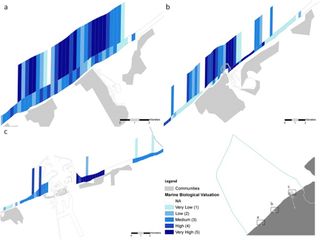
Biological valuation maps of areas located near three main harbours at the Belgian coastal zone: (a) Nieuwpoort (Lombardsijde); (b) Oostende (Oostende-East); (c) Zeebrugge (Baai van Heist).
File history
Click on a date/time to view the file as it appeared at that time.
| Date/Time | Thumbnail | Dimensions | User | Comment | |
|---|---|---|---|---|---|
| current | 13:26, 23 November 2017 | | 864 × 648 (68 KB) | Dronkers J (talk | contribs) | Biological valuation maps of areas located near three main harbours at the Belgian coastal zone: (a) Nieuwpoort (Lombardsijde); (b) Oostende (Oostende-East); (c) Zeebrugge (Baai van Heist). |
- You cannot overwrite this file.
File usage
The following page links to this file:
