The HIMOM and OFEW approaches to monitoring intertidal flats
Contents
Introduction
The proper management of coastal environments requires appropriate policy directives and tools that support fulfillment of the requirements of these directives. The European research project HIMOM (Hierarchical Monitoring Methods for Tidal Flats) provided a system of Hierarchical Monitoring Methods (HMM) consisting of different tools and methods to determine system change expressed by biological and physical variation within tidal flat areas (Brockmann et al., 2004[1]). It includes 34 protocols for ground sampling, primary production, remote sensing and data management. The HMM includes also categorized cost estimates so that end users can estimate the investment and running costs of implementing monitoring strategies of differing complexities.
The Hierarchy of HIMOM
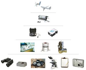
A system of Hierarchical Monitoring Methods (HMM) has been the basic concept of the HIMOM project (HIMOM, 2005). In the first year of the project, the HMM elements were defined and protocols for taking measurements, analysing the samples and the management of data were developed. Thirty-four individual protocols are now defined on a detailed level. They include techniques for sediment sampling, grainsize analysis, pigment extraction and analysis, primary production or remote sensing (Fig.1). The protocols have been compiled to a practical handbook for carrying out monitoring in intertidal areas. A hierarchy of methods exists in terms of costs, applicability, accuracy, information content, scale and detail. This means that several alternatives for measuring one parameter are included, and the HMM points out the alterna- tives, including their respective advantages and disadvantages. Therefore, it is possible for coastal managers to choose the best fitting methods for their monitoring concept and budget. An HMM-CD has been produced containing the book of protocols, demonstration material, an atlas of estuary maps and a case study for each member country. This gives the users all instructions and some practical hints for choosing and performing the different techniques. The HIMOM CD "HIMOM (2005): HMM-CD - Hierarchical Monitoring Methods for Intertidal Flats" can be obtained from Brockmann Consult or GKSS.
The Remote Sensing Approach in OFEW
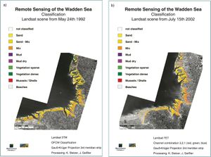
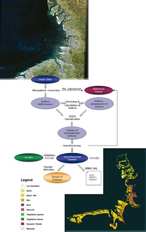
While Remote Sensing was one of the monitoring methods amongst others within the HIMOM-HMM, this methodology has been further investigated and developed towards an operational application within the OFEW project. Here, the classification of intertidal flats on the basis of multispectral satellite data has been standardised and tools have been developed in order to enable the responsible agencies to perform their own analyses. For the classification of satellite images, a processing chain has been developed including steps such as atmospheric correction and georectification and, finally, a classification of intertidal surface types (Fig. 2) (Stelzer & Brockmann, 2006[2]; Brockmann & Stelzer, 2008Brockmann[3]). In a similar way as in HIMOM, OFEW also works along a hierarchal approach - remote sensing data of different spatial and spectral resolution have been tested and adopted. The data material ranged from low cost aerial digital photos to hyperspectral scanner images and also includes satellite images of different resolutions.
Implementation
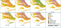
The protocols within HIMOM have been developed and successfully applied to tidal flats in Germany (Wadden Sea), The Netherlands (Westerschelde), Scotland (Eden estuary), Ireland (Barrow estuary) and Portugal (Tagus). An atlas of classification results has been produced by HIMOM as well as by OFEW. In HIMOM, the Atlas of European Estuaries shows the classifications and maps of the 5 European Estuaries investigated during the project phase. Extending the atlas, case studies presenting examples of application of the HMM for different thematic questions have been developed for the HIMOM CD. For each of the studied estuaries one case study demonstrates how questions on the state of the environment can be answered by applying HMM methods. The OFEW Atlas shows a time series of Landsat images from 13 different dates that have been classified with the standardised OFEW classification method. The earliest images were acquired in 1987, the third year of the long-living Landsat 5 TM sensor. Meanwhile, the sensor has been over 20 years in orbit and is still sending high quality data and images of our environment. The latest data in the atlas are from 2006, enabling change analysis and statistical studies over a period of almost 20 years of a uniformly processed dataset. Fig. 4 shows some examples of the maps.
Results
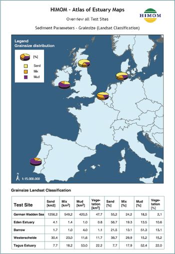
The HIMOM book of protocols, case studies and demonstration material is all available on the HMM-CD for practical use. The application of the methods in 5 different European Estuaries enabled a good comparison of methods and estuary characteristics (Fig. 3). Time series of intertidal flat classes can show changes in morphology and changes in sediment types over several years. Further, seasonal changes can be detected concerning the growth and extension of micro- and macrophytes (Fig. 5), assuming the availability of several images within one year. The availability of data is one of the constraints when using remote sensing methods for the interpretation of inter- tidal flats because, besides cloud coverage, also the tidal situation limits the number of images per year.
Outlook
In future projects remote sensing methods shall be further developed by the combination of optical data with other information sources such as surface roughness derived from radar data and background information. The background information will bring in expert knowledge about the ecosystem into the classification system. The responsible agencies for the operational monitoring will furthermore be involved in these activities and follow the outcomes. Discussions will continue on how those techniques and products can be integrated into the monitoring programmes.
References
- ↑ Brockmann, C., Stelzer, K., Consalvey, M., Forster, R., Jesus, B., Carsey, D., van Leeuwe, M., van Bernem, C., MacGregor, C. & Liek, G. (2004). HIMOM: A System of Hierarchical Monitoring Methods for Assessing Changes in the Biological and Physical State of Intertidal Areas. In Green et al. (Eds.), Littoral 2004. Delivering sustainable coasts: Connecting science and policy (Proceedings Vol. 1, pp. 273-278). Aberdeen: Cambridge Publications.
- ↑ Stelzer, K. & Brockmann, C. (2006). Optische Fernerkundung für die Küstenzone. In K.P. Traub & J. Kohlus (Eds.), GIS im Küstenzonen Management - Grundlagen und Anwendungen (pp. 56-65). Heidelberg: Hüthig GmbH & Co. KG.
- ↑ Brockmann, C. & Stelzer, K. (2008). Optical remote sensing of intertidal flats. In V. Barale & M. Gade (Eds.) Remote sensing of the European Seas, pp. 117-128. Netherlands: Springer.
Please note that others may also have edited the contents of this article.
|
Please note that others may also have edited the contents of this article.
|
