File:SeaLevel.jpg
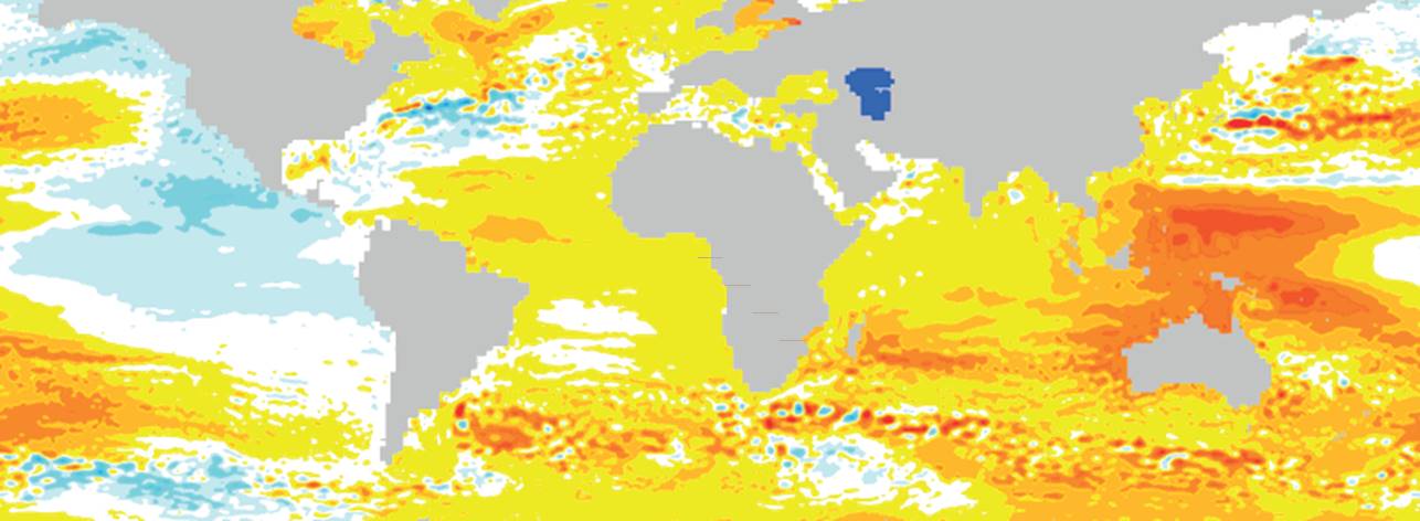
Map of rates of change in sea surface height (geocentric sea level) for the period 1993–2012 from satellite altimetry. From Church JA, Clark PU, Cazenave A, Gregory JM, Jevrejeva S, Levermann A, Merrifield MA, Milne GA, Nerem RS, Nunn PD, Payne AJ, Pfeffer WT, Stammer D, Unnikrishnan AS, 2013: Sea Level Change. In: Climate Change 2013: The Physical Science Basis. Contribution of Working Group I to the Fifth Assessment Report of the Intergovernmental Panel on Climate Change [Stocker TF, Qin D, Plattner G-K, Tignor M, Allen SK, Boschung J, Nauels A, Xia Y, Bex V, Midgley PM (eds.)]. Cambridge University Press, Cambridge, United Kingdom and New York, NY, USA.
File history
Click on a date/time to view the file as it appeared at that time.
| Date/Time | Thumbnail | Dimensions | User | Comment | |
|---|---|---|---|---|---|
| current | 13:40, 12 November 2016 | 1,286 × 472 (72 KB) | Dronkers J (talk | contribs) | Map of rates of change in sea surface height (geocentric sea level) for the period 1993–2012 from satellite altimetry. |
- You cannot overwrite this file.
File usage
The following page links to this file:
