Application of Land and Ecosystem Accounts (LEAC)
Contents
Introduction: EEA accounting framework adapted for PEGASO coastal accounting
Land accounting refers to a method designed to detect, depict and register the main types of landcover and their related human uses and functions in the landscape. It is a part of a bigger framework of environmental accounting, called Land and Ecosystem ACcounts [1], an innovative framework promoted by the European Environmental Agency (EEA) along the development of the United Nation’s System of integrated Environmental and Economic Accounts (SEEA1).
Accounts on species and habitats of European conservation importance address current state and changes in their number, abundance and conservation trends per unit area. The method produces quantitative estimates following specially designed mapping procedures, analysing the quality and quantity (area) of land and biodiversity resources and their changes in time. The results are presented per unit area of interest, be it an administrative region, a country, a coastal area or a protected area, in the form of statistics and maps.
For this, the method was included in PEGASO’s toolbox (WP4), to be explored and tested as a decision support tool relevant in Mediterranean and Black Sea coastal management context. It is expected to contribute with information relevant for two points of policy importance: characterizing the state and change in natural capital and its damage from urban sprawl in the coastal regions. The aim of PEGASO is to build on existing capacities and develop common novel approaches to support integrated policies for the coastal, marine and maritime realms of the Mediterranean and Black Sea Basins in ways that are consistent with and relevant to the implementation of the ICZM Protocol for the Mediterranean. In summary, the key objectives of PEGASO are to:
- construct an ICZM governance platform, consistent with the aims of article 14 of the ICZM protocol for the Mediterranean, to support the development of integrated policies for the coastal, marine and maritime realms of the Mediterranean and Black Sea basins;
- build in collaboration a spatial data infrastructure (SDI) for the Mediterranean and the Black Sea
- refine and further develop efficient and easy to use tools for making sustainability assessments in the coastal zone;
- test and validate the assessment tools at regional and local scales to understand both global and cumulative local trends and how they interact in specific coastal and marine regions;
- support an integrated regional assessment for the Mediterranean and Black Sea coastal and maritime areas; and,
- establish and strengthen mechanisms for networking and capacity development so as to promote knowledge transfer and the continued use of the project outputs.
Land accounts results – to assess urban sprawl on the coast
A simplified version of the EEA’s land accounting scheme was developed for an application in the Mediterranean and the Black sea basins, the study area of PEGASO. Simplified land accounts include a clear description of what the minimum application needs: land cover dataset for time 1; land cover dataset for time 2 (each with explained legend nomenclature specifying how the value of natural capital is interpreted and encoded in distinct classes); changed land-cover (detecting where changes happened, specifying the nature of the changes and the system defining values to judge whether there is loss or gain in natural capital).
Dataset for the Mediterranean and Black Sea basins
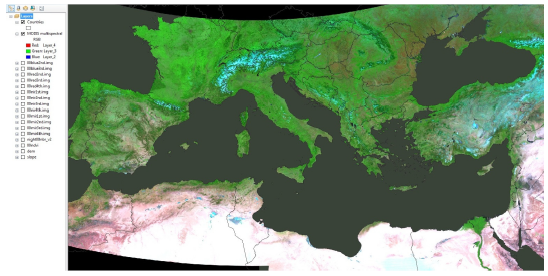
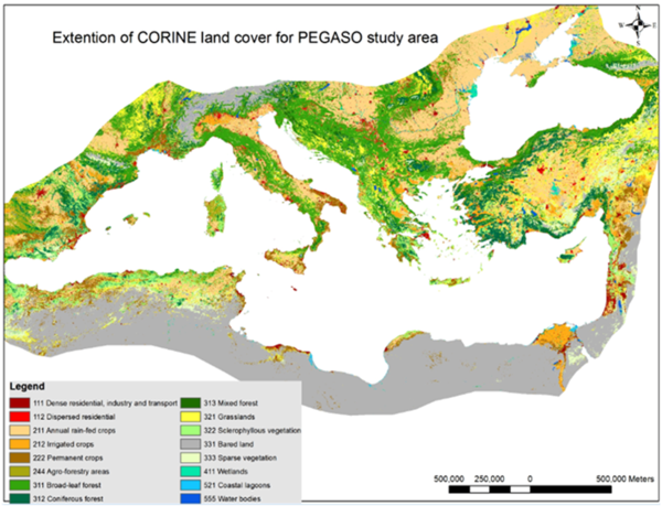
An extension of CORINE Land cover over the Mediterranean and Black Sea basins was developed using a set of data-sources: the European CORINE land cover for training a supervised maximum likelihood classification of MODIS multispectral and other geographic data.
Remote sensing data:
- MODIS land products cover the whole globe with freely accessible data (highest detail at 250 m2 resolution) since 2000. It includes classified land cover maps (annual, at 500m x 500m but not suitable for multi-temporal analysis); vegetation indices and multispectral reflectance data (at 250m x 250m, every 14 days). These products were chosen for testing the possibility to reproduce a selection of classes from CORINE land cover, at a medium resolution and compatible with the original CORINE land.
- DMSP-OLS Night-time Lights Time Series contains global annual images of nightlight intensity at 1km x 1km resolution. The images are composites of cloud-free scenes using all available smooth resolution data acquired during each calendar year since 1992.
Classified land cover/land use data: CORINE is a standardised land cover inventory (at 100m x 100m spatial resolution) derived from satellite imagery for three dates (1990, 2000 and 2006) for the EU and EEA associated countries.
Other geographic data: SRTM 90m Digital Elevation Data (DEM) was produced originally by NASA in 90m resolution at the equator. For the current application a resampled version was used at 250m resolution. Slope and aspect layers were derived from the DEM. The method has allowed reproducing the European CORINE land cover product, in a modified way, over the African and Near-east Mediterranean areas and East European temperate areas for the years 2000 and 2011. 16 out of the 44 classes of the CORINE nomenclature could be reproduced in this way.
Table 1: Hierarchical nomenclature for PEGASO land cover derived and adapted from LC CORINE
| Land cover Level 1 | Level 2 | Land cover level 3 | ||
|---|---|---|---|---|
| Urban and artificial cover | 1 | 1 | 111 | Dense residential, industry and transport |
| Urban and artificial cover | 1 | 1 | 112 | Dispersed residential |
| Agricultural land | 2 | 21 | 211 | Annual rain-fed crops |
| Agricultural land | 2 | 21 | 212 | Irrigated crops |
| Agricultural land | 2 | 22 | 222 | Permanent crops (orchards, vineyards, olives) |
| Agricultural land | 2 | 22 | 244 | Agro-forestry areas |
| Forest and semi-natural cover | 3 | 31 | 311 | Broad-leaf forest |
| Forest and semi-natural cover | 3 | 31 | 312 | Coniferous forest |
| Forest and semi-natural cover | 3 | 31 | 313 | Mixed forest |
| Forest and semi-natural cover | 3 | 32 | 321 | Grasslands (merged with pastures) |
| Forest and semi-natural cover | 3 | 33 | 322 | Sclerophyllous vegetation |
| Forest and semi-natural cover | 3 | 34 | 333 | Sparse vegetation |
| Forest and semi-natural cover | 3 | 34 | 333 | Bared land (beaches, rocks) |
| Wetlands | 4 | 4 | 411 | Inland marshes and salt marshes |
| Water | 5 | 5 | 521 | Coastal lagoons |
| Water | 5 | 5 | 555 | Water bodies (rivers, lakes) |
The nomenclature was modified by merging some classes and excluding others in order to ensure relative separability of the retained classes using the MODIS multispectral and other inputs at 250 m spatial resolution. For example all the classes characterised my continuous hard or paved surface were merged in a single class ‘111’, while the class of discontinuous urban land, including open spaces (agriculture, parks, green areas) is kept separate ‘112’.
For PEGASO the land cover maps were produced for years 2000 (Fig. 2) and 2011 at 250x250m resolution and classification nomenclature designed for producing land accounts.
Validation land accounts
This product is still under development, and therefore the current results are presented in a way to emphasize the options available for improvement, rather than the possible highest quality output, as defined by the accuracy assessment, which shows 70 % agreement (Kappa coefficient) between CORINE land cover and PEGASO land cover at level 1, for the five major classes: urban land,agricultural, natural and semi-natural, wetland and water. At level 2, 9 classes and agreement is 60 % and level 3 with 16 classes the overall agreement is 51 %.
Further validation work is needed for areas outside the coverage of the European Corine Land cover, e.g. over the north-African, Near-east and East Europe areas.
Land Accounts estimation
Once the accounting inputs were produced, namely the above two land cover maps for years 2000 and 2011, stocks and flows were analysed at level two, the following 9 classes:
| 1 | Urban and artificial covers |
| 21 | Intensive agriculture |
| 22 | Mixed and extensive agriculture |
| 31 | Forest |
| 32 | Grassland |
| 33 | Shrubland |
| 34 | Desert and sparse vegetation |
| 4 | Wetlands |
| 5 | Water |
The following data processing steps were done for estimating and extracting land accounts for years 2000 and 2011:
- Each of the nine classes was first converted to a Boolean map at 250m x 250m resolution;
- From the nine Boolean maps, block statistics were estimated at 4 x 4 cells window, the sum statistic of which amounts to the number of cell belonging to the respective land cover type;
- From the nine block statistic maps, the corresponding 1km x 1km maps was derived showing the number of hectares per land cover type;
- Then the nine maps of land cover hectares were integrated into a database which links the number of hectares with a 1 km reference grid for the entire study area, additionally the 1 km grid is linked to units of interest, including countries, administrative divisions, river catchments, protected areas and three buffers around the coast (1, 10 and 50km distance); and,
- The integrated database is then queried using excel pivot tables to extract the accounts per unit of interest.
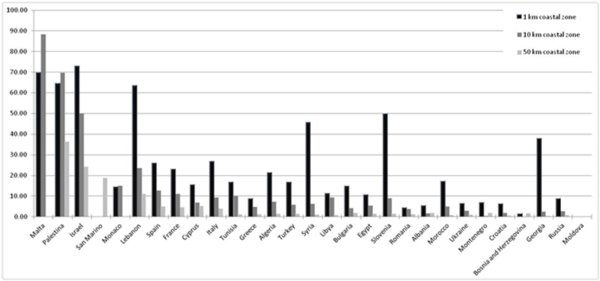
Figure 3 shows the degree of coastal urbanization in year 2011 for the Mediterranean and Black Sea countries, expressed as a percentage from the total area for three coastal buffers within each
This figure illustrates the much higher percentages of urbanization concentrated within the first km of the coast.
The time difference of change in urban area between years 2000 and 2011, expressed in percentages from total area in each of the three buffers is shown below:
| Buffer zone | Mediterranean coast | Black Sea coast | Entire area | |||
|---|---|---|---|---|---|---|
| Area (ha) | % | Area (ha) | % | Area (ha) | % | |
| 1 km from coast line | 12625 | 0.48% | 2018.75 | 0.60% | 14643 | 0.49 % |
| 10 km | 57350 | 0.26% | 6012.5 | 0.19% | 63362 | 0.25 % |
| 50 km | 110006.25 | 0.17% | 3393.75 | 0.03% | 113400 | 0.15 % |
These rates of urban sprawl within the last decade imply that there was more urbanization in the first kilometer buffer on the Black Sea coast.
Species and habitat accounts to assess natural capital preservation
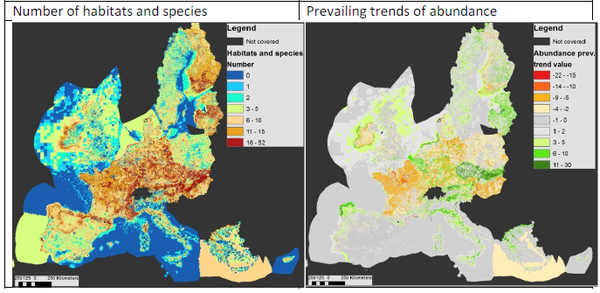
Accounts on habitats and species of European conservation importance were developed and extracted applying a methodology developed by the Centre for Environmental Management (CEM) at the University of Nottingham and the EEA [2]. For the European ecosystem accounts it was decided to explore the information available for a preselected subset of 1059 species (plants, mammals, amphibians, reptiles, arthropods) and 231 habitats included in the Annexes of the Habitat Directive (Council Directive 92/43/EEC), which have been considered through a policy processes as having European conservation importance. The following accounting elements were defined and mapped:
- A number of species and habitats of European conservation importance present in a given area (representative for the time when the countries carried out their assessments for the period 2001 - 2006); and,
- Quantitative changes in species’ abundance and habitats’ coverage. For species, the abundance change is expressed as either increasing, stable or decreasing trend in their population size and for habitats - increasing, stable or decreasing trend in their coverage.
In addition, the following indicators were estimated for summarising the performance of conservation policies at European level:
- prevailing trend of the population sizes of the species and the coverage of the habitats present in a given area. The prevailing trends are indicative of possible changes in conservation status since the first identification and designation of the habitats and species in the 90-ies; and,
- the species’ prevailing future prospects were mapped too, which can help to assess whether the current trend in conservation success may continue or change in the near future.
Although all of these elements and indicators are available in a spatially explicit form and harmonized on European level in a single geo-database (Articla 17 database), further spatial data processing and analyses were needed to estimate the accounting outputs.
Input datasets selection and processing
Article 17 data are reported by the EU member states, and harmonized by the European Topic Centre on Biodiversity as part of the implementation of the European NATURA2000 network. The latter was set up by the EU in response to its commitments under the Convention in Biological Diversity and the political commitment of ‘significantly reducing the current rate of biodiversity loss by 2010’ ([ec.europa.eu/environment/nature/biodiversity/comm2006/2020.htm/ European Commission, 2009]).
The assessment of the ‘conservation status’ for species is based on trends in range, population, habitat quality and future prospects, and for habitats – trends in range and coverage. The Member States followed an agreed set of guidelines, but produced and reported their assessments at a varying level of detail and quality in relation to species and habitats distributions and their conservation status. Conclusions about the conservation status were summarised in an additional set of categories defined by an agreed set of criteria, where 'favourable conservation status' (FCS) is the category that represents the overall objective to be reached for all habitat types and species of Community interest. In the context of a species, it describes situations where the population dynamics are interpreted as indicating that it is maintaining itself on a long-term basis as a viable component of its natural habitats, and that its range is neither reducing for the foreseeable future, and will continue to be sufficiently large to be maintained in the long-term. When a species is assessed as falling short of these criteria it is reported as having ‘unfavourable conservation status’; this can be deemed either ‘inadequate’ or ‘bad’, depending on the severity of the conservation threats that are facing it. Figure 1 shows the current situation for Europe.
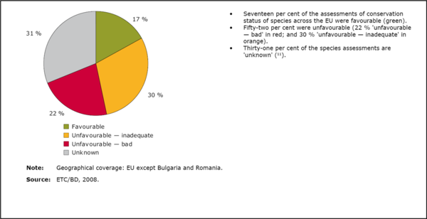
Figure 4 presents the Article 17 species data at a highly aggregated way. The rich body of information that lies beneath it can, however, be used to construct more detailed, spatially specific measures of biodiversity status that could provide one input to the proposed experimental accounts. Specifically, the underlying Article 17 database provides:
- The species and habitats distribution ranges harmonized for a 10 km x 10km grid for EU 25, for around 2000 species of Community Importance.
- The detailed status assessments for the elements that informed the final judgment about conservation status for each species, namely:
| Species of community importance | Habitats of community importance | |
|---|---|---|
| Trends | Trends of change in range size, habitat quality and population size | Trends of change in range and area coverage |
| Future prospects | An indication of the likely future prospects for the species | |
| Conclusions | The conclusions made in relation to: the size of the species range; the size of the species population; the quality the species habitat; the future conservation status of the species; and, the overall assessment about the species conservation status. | The conclusions made in relation to: the size of the habitat range; the area coverage; the habitat structure; the future conservation status of the habitat; and, the overall assessment about the habitat conservation status |
Each of the trend parameters are assessed as: decreasing, unknown, stable and increasing trend. The future prospects can be either: bad, poor unknown or good. The analysis of the nine parameters can then be used to define a degree of consensus on the species conservation status and future. As a first step, however, only two parameters were selected and processed to build a species account, the trend of change in population size and future prospect; and one for the habitats, the trend of change in area coverage. The trend in population size for species and area coverage for habitats were selected, for being the parameter most often defined on the basis of quantitative evidence, e.g. counts of individuals for each species or counts of location where it is found (more for the habitats), an estimate of minimum and maximum population size and further references.
To address the limitation of varying spatial detail of the reported species’ and habitats’ distribution ranges, an additional procedure for enhancement and harmonization of their distributions was developed. Thus the original ranges in 10km x 10km grid were adjusted using the European CORINE land cover (LC) map for year 2000[4], at a resolution of 250m. CORINE LC is a standardised land cover inventory derived from satellite imagery for all the EU and EEA associated countries for three dates: 1990, 2000 and 2006. The spatial adjustment was possible for a subset of the reported species and habitats, according to their likelihood to be found within broad ecosystem types. Further each broad ecosystem type was characterised and mapped by a grouping of CORINE LC classes. The matching of species to ecosystem types and land cover classes is defined by experts and included in Annex 3 of the EU 2010 Biodiversity Baseline (EEA Report No 12/2010). The majority of the species and habitats assessments were retained in this subset; from the original 5885 species, 4580 were retained, and from the 2879 habitats, 2834 were retained.
| Ecosystem type | Land cover types | |
|---|---|---|
| 1 | Agro-ecosystems | Rainfed and irrigated arable lands, permanent and mixed cultivations |
| 2 | Grassland ecosystems | Pastures and natural grasslands |
| 3 | Shrubland ecosystems | Scherophyllous veg., moorlands, transitional woodlands |
| 4 | Forest ecosystems | Coniferous, broadleaf and mixed forest |
| 5 | Wetland ecosystems | Inland marshes and peatbogs |
| 6 | Freshwater ecosystems | Lakes and water sources |
| 7 | Coastal ecosystems | Beaches, dunes, rocks, lagoons, estuaries, salt marshes, intertidal flats |
| 8 | Marine ecosystems | Sea water |
Hence, the expert-identified relations between species and habitat distribution within broad ecosystem types and the broad ecosystem types being defined by a set of land-cover classes, were applied to downscale the original coarse ranges at 10km x10km to likely distribution patches at 250m x250m. We expected that in this way the varying spatial detail of the reported species and habitat ranges would be harmonized and improved. For example, ranges which were reported rather generally covering entire regions, would be improved by masking out unsuitable areas, such as urban residential or industrial zones). However, in the original tables of expert-identified relations the species and habitat were usually included in more than one broad ecosystem type, and also the same land cover classes were included in more than one ecosystem types. Therefore the downscaling procedure was designed in a way allowing to have all species and habitat represented in each ecosystem type, according to the expert definitions; but then all repetitions to be cleared out by allocating each ecosystem type on non-overlapping CORINE land cover class groupings. The data processing steps were as follows:
- linking species/habitat to broad ecosystem type and conservation assessment values;
- separation of the species and habitats into eight groups according to their belonging to a broad ecosystem type;
- intersection each of the eight subsets with a 10km x 10km European reference grid;
- extraction of counts of species/habitat numbers per grid cell in six items: decreasing trend, stable trend, unknown trend, non-assessed, increasing trend and total number and likewise for future prospect;
- linkage of each of the accounting items to the 10km x 10km European grid;
- conversion of each of the 6 item per ecosystem type to a raster layer for both habitats and species;
- mapping of the eight ecosystem types as filters (Boolean, with value 0 or 1), in a raster layer by grouping the non-overlapping CORINE LC classes;
- application of the filter per ecosystem type at 250m x 250m spatial resolution for each of the accounting elements separately;
- estimation of accounting inputs of interest, for example total number of species and habitats of community importance, also total number of species and habitats with increasing, decreasing and stable trends of change; and,
- estimation of spatial indicators to judge conservation success at aggregated level, for example a prevailing trend of population size changes and prevailing future prospect for species.
In this way we estimated spatially explicit accounting inputs for species and habitats of European conservation importance, using the assessments from the Art. 17 first reporting period 2000 – 2006. The results at this stage are intended as a testing demonstration of the methods applied for a wide area and using incomplete and varying quality inputs. They need further improvement, validation and harmonization before being recommended for policy informing applications. Nevertheless, for the purposes of PEGASO, these inputs were used to estimate species and habitats accounts shown below.
Extraction and application of species and habitats accounts
Accounts on species and habitats of European conservation importance were extracted for the NATURA2000 sites designated on both the terrestrial and the marine part of the EU Mediterranean countries. Mean values of species and habitats numbers for all the sites within a country, as well as mean prevailing trend are shown in the table below.
| Country | NATURA2000 estimates | Estimates out of NATURA2000 | ||||||
|---|---|---|---|---|---|---|---|---|
| Terrestrial and marine area (ha) | NATURA2000 area (ha) | % from total | Number of sites | Mean number of spec. and habitats | Mean prev. trends | Mean number of spec. and habitats | ||
| Cyprus | 10730760 | 227242.1 | 2.1 | 61 | 5.2 | 0.4 | 2.6 | 0.1 |
| Spain | 151007357 | 18885693.4 | 12.5 | 1802 | 5.9 | 0.4 | 5.3 | 0.3 |
| France | 99255446 | 15308037.4 | 15.4 | 1753 | 11.1 | -1.0 | 9.5 | -2.6 |
| Greece | 62559851 | 5528397.1 | 8.8 | 419 | 4.9 | 2.0 | 4.1 | 1.4 |
| Malta | 5575842 | 24177.2 | 0.4 | 39 | 2.0 | 0.3 | 1.3 | 0.2 |
| Italy | 83915746 | 7784734.0 | 9.3 | 2565 | 5.6 | 3.1 | 2.8 | 1.7 |
| Slovenia | 2040757 | 1101634.5 | 54.0 | 286 | 9.2 | 0.4 | 9.1 | -0.1 |
These mean values indicate that numbers of habitats occur proportionally higher in the countries where more area is designated within NATURA, the prevailing trends within NATURA are also higher in comparison with the mean values from the areas out the NATURA2000 network. The accounting methodology and the estimated accounting elements was presented to the team for developing coastal ecosystem accounts in the FP7 project PEGASO with a view of extending the accounts over the north African, near-East and Black Sea coasts using datasets from IUCN and other sources. First the list of species of European and Mediterranean conservation importance (species listed in Annex II of the Protocol concerning Specially Protected Areas and Biological Diversity in the Mediterranean) were compared. The latter includes 105 species, of which 32 are also of European conservation importance (and hence already processed in the current accounts). The Mediterranean list targets only marine species and they are not the only ones relevant to coastal management, when considered at a wider context and scale. Therefore more species characteristic of the terrestrial and wetland parts of the coastal areas need to be included in the accounts to be prepared for the South and East Mediterranean and the Black Sea basin.
Further the available accounts can be refined for areas where more detailed and accurate biodiversity data exists, in spatial quality terms, as well as more certain conservation status changes.
For more information, read the factsheet
Please note that others may also have edited the contents of this article.
|
References
- ↑ Weber, J.-L. (2007): Implementation of land and ecosystem accounts at the European Environment Agency. Ecological Economics 61: 695 – 707.
- ↑ Ivanov, E.D; Weber, J.-L.; Spyropoulou, R. and R. Haines-Young (2013): Developing an accounting method for species and habitats of European conservation importance. CEM Working Paper No 11_Version 3.0, 18 pp. (download: http://www.nottingham.ac.uk/CEM/WorkingPapers.html)
- ↑ EEA (European Environmental Agency) (2011): An experimental framework for ecosystem capital accounting in Europe. EEA Technical Report TR13/2011, Copenhagen (Author: Jean-Louis Weber).
- ↑ EEA (European Environmental Agency) (2006): EU 2006. Land accounts for Europe 1990–2000: Towards integrated land and ecosystem accounting. EEA Report No 11/2006, Copenhagen (Authors: Roy Haines-Young and Jean-Louis Weber)
