French case studies: Upper tidal flat evolution in the bay of Mont-Saint-Michel (NW France)
Contents
Introduction
In the Normandy-Brittany gulf (France), the Mont Saint-Michel Bay is famous for its very large tidal range (spring tidal range up to 14.5 m) generating an exceptional extension of the intertidal zone over an area of 250 km² (LARSONNEUR et al. 1989). This macrotidal environment comprises two distinct sedimentary systems (BONNOT-COURTOIS et al. 2002): 1) The western part (Cancale bay) is a sheltered embayment subjected to moderate rotational tidal currents and protected from North-West dominant swells. This area is characterized by the presence of extensive oyster beds developed in the lower and intermediate mud flat since the beginning of the XXth century. 2) The eastern area corresponds to a large estuary, formed by the confluence of three rivers (Sée, Sélune and Couesnon) nearby the Mont Saint-Michel. The flood currents progress towards the South-East along the median axis of the bay and spread at the entrance of the estuarine zone where alternating currents increase in the tidal channels. The upper part of the sand flat is occupied by salt marshes spreading over a very large area and their progradation has been very important since 1950. Between these two sectors, the southern part of the bay is a tide-dominated mixed flat, intermediate between the western mud flat and the eastern sand flat. The upper tidal flat of this southern embayment is marked by numerous shell banks that form and migrate progressively onshore under swell action.
Shell bank morpho-dynamics
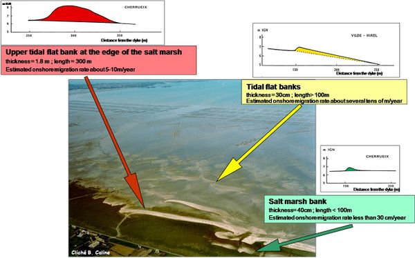
Consisting of coarse biogenic sands rich in well-preserved shells, the shell banks can be grouped into three morphological types according to their size and their position within the tidal environments (Fig. 1). The salt marsh banks, incorporated in the upper part of the salt-marsh, are relatively stable, their migration rates not exceeding a few cm/year. The upper tidal flat banks are widely developed at the edge of the salt-marsh, with a great spatial extension and a thickness up to 2 m. The onshore migration rates of these banks is around 5 to 10 m/year. The mid- to upper tidal flat sandy banks migrate from the lower part of the tidal flat towards the coastline at a rate of several tens of m/year.
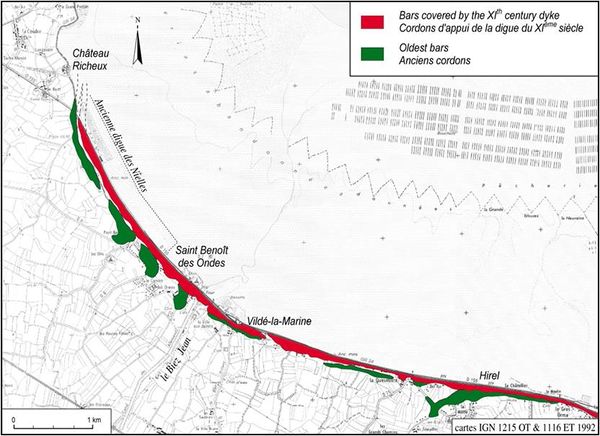
These calcareous bioclastic accumulations extend parallel to the shoreline and the coastline is underlined by a 15 km long dyke. This dyke, built in the XIth century, is based on an alignment of old shell banks which formed a natural littoral barrier similar to the ones occurring in the upper tidal flat today. The original morphology of the banks has been preserved in the North-West part of the littoral marsh, where two sandy-shelly banks, almost parallel and continuous, occur (Fig. 2) (L’HOMER et al. 1995). The external bank, completely man-managed, has been used as a dyke road, while the older one, located behind the marsh, has preserved a contrasted morphology, with traces of old breaches and small internal sand spits.
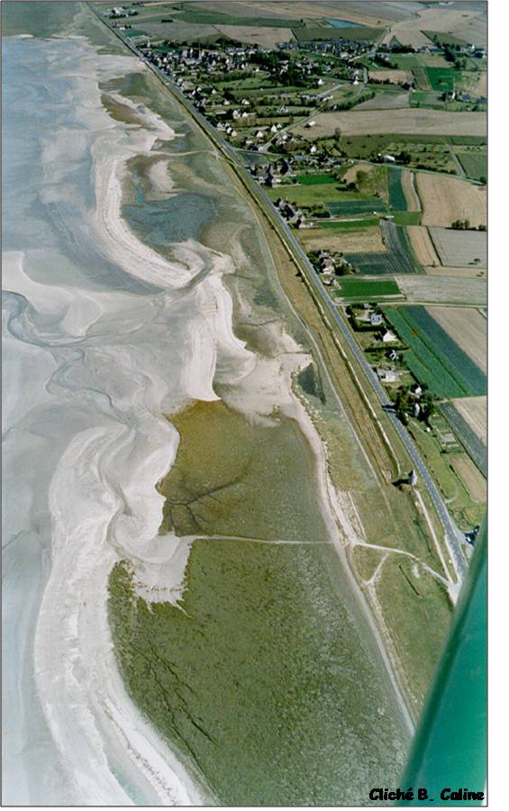
At the present time, the shell banks of the upper tidal flat are forming a continuous coastal barrier, at least thousand years later than the oldest bars (Fig. 3). From West to East, all the stages of shell banks evolution are represented, from the oldest quite fossil bars, close to the coastline, to the most recent dynamic tidal flat calcareous accumulations.
Salt marsh dynamics and recent evolution
At the present time, salt marshes are spreading over very large areas in the eastern part of the Mont Saint-Michel Bay. In the estuarine zone, they are spreading on the upper tidal flat where they extend over a width of 3 km on either side of the Mont Saint-Michel. The progradation of the salt marshes has been very important since 1950, and the most upper part of the salt marsh is occupied by a rectilinear dyke which protect polders constructed between 1850 and 1934.
The distribution of the different types of vegetation is related to the degree of submersion that each species can support, and consequently to the sediment level and tidal range. The upper part of the salt marsh is dominated by graminae (Chiendent and Fetuque) and is reached only by the highest tides (Extreme High Water Spring Tide). The intermediate and lower salt marsh presents various species (mainly Obione and Puccinellie) which distribution depends on drainage and tidal channels vicinity. This part of the salt marsh is comprised between Mean High Water Spring Tide and Mean High Water levels. The upper tidal flat extends below the Mean High Water level down to the Mean High Water Neap Tide where species are able to be submerged by seawater during a long period (Fig. 4)
Fig. 4 : Salt marsh zonation nearby the Mont Saint-Michel
The colonization stages of the tidal flat by the halophile vegetation have been accurately described by the study of the evolution of the schorre surfaces and by the analysis of the interaction between vegetation and sedimentation (BONNOT-COURTOIS & LEVASSEUR, 2000). The progradation of the salt marsh is guided by the dendritic morphology of the tidal channels which determines the formation of bank levees separating depressions between two channels. The bank levees are initially occupied by Spartina anglica and Puccinellia maritima, together with annual species (Salicornia herbacea and Sueda maritima). The depressed areas between the tidal channels are badly drained and will be later colonized by various types of halophile species such as Atriplex portulacoïdes (Obione), Aster tripolium. As the sediment accretion progress, the schorre becomes an almost continuous plant cover and more “continental” but still halophile species (Elymus pungens, Festuca rubra v. littoralis) take progressively the place of the first one.
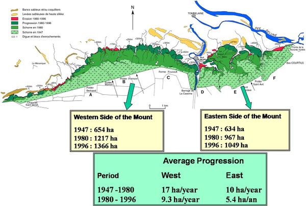
A comparative study of IGN aerial photographs, taken since 1947, shows a strong progradation of the salt marsh on either side of the Mont Saint-Michel. The schorre external limits have been reported on Fig 5 for 1947, 1980 and 1996 and the surfaces covered by vegetation have been calculated for the Western side and the Eastern side of the Mont Saint-Michel. The rates of progradation are varying from 5 to 17 ha/an and the western side of the Mont Saint-Michel progress more than the eastern sectors. For the period 1947 – 1980, the rates of progradation are above 10 ha/year and they are decreasing during the second period 1980 – 1996. Nowadays, the global progradation of the salt marshes on both sides of the Mont-Saint-Michel is around 15 ha/year.
On the contrary, the edge of the schorre is eroded in some sectors which is related to channel divagations, especially for the large tidal channel occurring in the eastern sector in the « Grand Banc » salt marsh. These erosions are also linked to the rivers channels which wandered to the East in 1993 for the Couesnon and to the South for the Sée-Sélune channel during the levelling down of the Roche Torin submersible dyke in 1983.
Field measurements (sediment traps) conducted in 1999 allow an estimation of the sediment accretion at the edge of the salt marsh. Several hydrodynamic regimes occurs at the edge of the schorre. The accretion rates have been estimated to a few cm/year in the lower part of the salt marsh. The upper parts generally present lower values (0.2 cm/year). On the contrary, the external upper tidal flat experiences very high accretion rates, ranging from 3 cm/year for the western mud flat to more than 5 cm/year for the eastern sand flat.
An old map, drawn in 1775, shows a great extension of the salt marsh in the western area surrounding the Mont Saint-Michel and the ancient Couesnon estuary flowing towards the North-West. A significant section of the upper tidal flat which today forms the polders corresponds to the ancient salt-marsh that outlines the depositional silting-up of the estuary as early as the end of the XVIIIth century. The continuous wandering of the river channels caused lateral erosion and the canalization of the Couesnon mouth was carried out in 1863. New polders were then established on the areas where the river no longer flowed, with plans to build levees which would incorporate the Mont Saint-Michel into dry land. These polders have been constructed between 1851 and 1934 when the limits of the concession was reached. At the present time, the last dyke corresponding to the coastline separates the polders from the upper salt marsh, only submerged by the highest high spring tides.
Related articles
References
Bonnot-Courtois C. & Levasseur J.E. (2000) – Rétablissement du caractère maritime du Mont Saint-Michel. Etudes en Environnement, volume 5. Contribution à la connaissance de la dynamique des herbus. Rapport DDE/Syndicat Mixte/Univ. Rennes 1/ UMR 8586 PRODIG CNRS. 196 p.
Bonnot-Courtois, C., Caline B., L’Homer A., Le Vot M. (2002) - La baie du Mont Saint-Michel et l’estuaire de la Rance. Environnements sédimentaires, aménagements et évolution récente. [The bay of Mont-Saint-Michel and the Rance estaury. Recent development and evolution of depositional environments]. Bull. Centre Rech. Elf Explor. Prod. ,Mém. n° 26, 256 pp.
Bonnot-Courtois C., Fournier J., Dréau A. (2004) - Recent morphodynamics of shell banks in the western part of Mont Saint-Michel Bay (France). Géomorphologie, relief, processus, environnement. n° 1, p. 65-80.
Larsonneur C. et coll. (1989) - La Baie du Mont Saint-Michel. Bull. Inst. Geol. Bassin Aquit. vol. 46, 1989, p. 1-75.
L’Homer A., Caline B., Bonnot-Courtois C. (1995) - Intérêt archéologique des bancs coquilliers du secteur occidental de la baie du Mont Saint-Michel. In Langouët et Morzadec-Kerfourn M.T. (Dir) « Baie du Mont Saint-Michel et marais de Dol ; milieux naturels et peuplements dans le passé ». Dossiers du CeRAA. ed. Centre Régional d’Archéologie d’Alet, Saint-Malo. Suppl. n° R, 47-58.
Please note that others may also have edited the contents of this article.
|


