Human activities and nature conservation conflicts at the Kenyan coastline
Contents
Introduction
The Kenyan coastline is approximately 500 km long, with a well developed fringing reef system except where major rivers (Tana and Athi Sabaki) discharge into the Indian Ocean (Hamilton and Brakel, 1984[1]).The coastal zone environment and its resources in the western Indian Ocean(WIO) region countries: Kenya, Tanzania, Mozambique, Seychelles, Mauritius and Comoros play an important role in the economy of the people.
Population growth, loss of social and community identity, lack of resources, hunger and poverty are the central problems of Kenyan coastal area. The development process has meant that effective and sustainable management is no longer feasible, despite the availability of resources.
Activities
Fishing
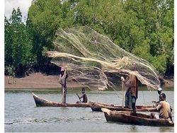
The fishery sector contributes about 4.7 % of the national Gross Domestic Demand (GDP) and it is an important foreign exchange earner. The marine fisheries sector in Kenya land about 10,000 tonnes of fish which accounts for about 10 % of the total fish landed in Kenya. Marine fisheries in Kenya are based on a small number of species, the most important of which are demersal and caught by artesian fishermen operating between the shoreline and the reef. Conflicts exist between small marine fishers and financially powerful companies, for example who purchase and occupy large tracts of coastal land for tourism, in the process they block access to the sea and prevent landing of catches. Marine fisheries in Kenya are mainly, artisanal and undertaken mostly from small, non motorized boats such as outriggers, dhows, cataracts and planked pirogues. Only about 10% of fishing craft are motorized. This constraint limits most of the fishing effort to inside the reef and rarely is fishing undertaken beyond territorial waters (20 km).Local fishers use the most rudimentary equipment which has exacerbated the problem of over fishing in coastal waters. The tried and tested traditionally methods used in the past as part of culturally based resource management can no longer be used or are no longer effective
Prawn trawling
In the rich inshore fishing grounds within the Malindi-Ungwana Bay area prawn trawling has been carried out since the 1970's. The fishery is also associated with very high conflicts due to the destruction of traditional fishermen fishing nets, competition for common resources, distrust between the semi industrial prawn industry and the local fishermen, and the rampant resources wastage because of the high amount of fish by-catch associated with prawn trawling.
Marine farming
Marine farming activity in Kenya is in its infancy. Besides some traditional brackishwater ponds and artesian shrimp and oyster cultivation, coastal aquaculture has been restricted to capital intensive shrimp culture on an experimental scale.Unfortunately, this development at Ngomeni has been undertaken at the expense of mangrove productivity, with 60ha of mangrove forest being cleared. However, in spite of this inauspicious beginning, coastal aquaculture in Kenya has considerable potential as a source of economic return and, if properly planned and managed, it need not have an impact on the productive and valuable mangrove ecosystems.
Exporting Kenya's coral reef fish
These are exported for use in marine aquariums worldwide. Among the key concerns about the fishery has been the potential of over-harvesting the target species, hence resulting in changes in population dynamics and destruction of coral reef habitats.
Turtle egg trade
Of the seven known species of marine turtles in the world, five are found in Kenya. They are loggerhead, leatherback, olive ridley, hawksbill and green turtle. Three of them, the green, the hawksbill and the olive ridley nest in Kenya while the others only come to forage.Trade in turtle eggs has been a source of income for many fishing communities not only on the Kenyan coast but throughout the entire Indian Ocean region where most of them depend on coastal resources for livelihood. The turtle egg is popular as a delicacy-with some believing it is an aphrodisiac while its shell is considered a choice material for decorative items among some coastal communities. Research has shown that although sea turtles have managed to survive natural hazards over the years they are now under severe threat from human activity.
Minerals and energy resources
Coastal geological formations are predominantly sedimentary in origin, with marine, shallow water and lacustrine fluviodeltaic characteristics. They form a strip of 50 km wide along the Southern part of Kenya coast. Mineral deposits that occur in economically meaningful quantities in the Kenyan coast include salt, coral rocks, limestone, rutile, ilmenite, building sand, pyrochlore, gypsum, barites, gypsum, silica sands, iron ore and clay. Other lesser minerals are apatite, galena, and manganese oxide.
Recent discovery of titanium ores (rutile and ilmenite) in the sedimentary deposits along almost the entire length of the Kenya coast has initiated national debate on environmental impacts of mining, particularly since the recent enactment of the Environmental Act. Tiomin Mining Company has already entered into agreement with the Kenyan Government to undertake mining at Kwale near Diani beach, which started in early 2006 and is estimated to continue for 11 years. This and other mining activities will result in an increasing amount of sea traffic particularly in Mombasa harbour from where ore will be shipped and mining supplies will arrive.
Salt works
Salt can be considered as the most widespread mineral in Eastern Africa and its recovery from the sea is a comparatively simple process given certain environmental conditions. Extensive salt works have been established at the Gongoni-Karawa.The total area dedicated to salt production is over 5,000 hectares that yield an average of over 170,000 tonnes of salt annually (UNEP 1998).
Limestone and cement
Limestone deposits are extensive along the coastal zone from the Tanzania border to the Malindi area. The resource is very abundant, forming a 4-8 km wide band, some 70m thick, running parallel to the coast. Exploitation of the limestone is widespread and is governed by local variation in the limestone texture, composition and demand for the material. In the Bamburi area north of Mombasa, limestone is used for cement manufacturing and in Tiwi for lime manufacturing. However, all along the coast limestone is being exploited for building stone.
Oil and gas exploration
Good source rocks and reservoir rocks for hydrocarbon deposits have been observed along the Kenyan coast, with conditions becoming more favourable offshore. Promotion efforts generated new interests in the offshore. Lamu Basin and an Australian firm is at an advanced stage with efforts to sink initial exploratory wells about 70km off the Lamu coast (https://nationaloil.co.ke/).
Tourism
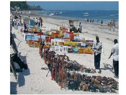
The first hotels directed at tourism were built in Malindi during the early part of the 20th century. In the last thirty years, rapid expansion in the recreation and tourism industry has occurred. The main attractions for this new industry include the warm coastal climate slightly mellowed by a cool sea breeze, the beautiful coastal scenery and foremost, the beautiful and clean sandy beaches. All the facilities that support the new expansion in the tourism industry are therefore located next or adjacent to beach environments. In some areas, such as the coastal strip around Mombasa, the rapid development of tourism has put pressure on the sustainable use of coastal resources such as the coral reef. Demand for seafood, shells and coral souvenirs has risen sharply as local supplies have become depleted. The pressure on the coastal ecosystem extends further and further from the resorts, spreading the impact.
Current situation and threats for Kenyan coastal systems
Alien species
Though not well documented alien species are on the rise probably due to ballast water and human introduction, the effect of this is yet to be known.
Mangroves
A particular concern has been the clearing of mangrove areas to reclaim land for other uses such as aquaculture, salt manufacture, agriculture and housing. About 10 000 ha of mangrove areas have been cleared for salt manufacture between Ngomeni and Karawa, while in Lamu, close to 100 ha of mangrove forest was killed by dredged-up sediment that was deposited during the construction of the Mokowe sea jet. 100 ha of mangrove area have been converted for aquaculture at Ngomeni. At Gazi Bay, about 100 ha of mangrove forests were cleared for fuelwood and in Makupa Creek, Mombasa, 10 ha of mangroves died due to oil pollution. The total area lost is therefore 10 310 ha which represents about 20% of the total mangrove forest.
Pollution
Environmental quality in the coastal and marine environments of Eastern Africa is under increasing pressure from land- and sea-based sources of pollution. Land-derived agrochemical and municipal wastes and sea-based petroleum wastes are the major causes of pollution in the sub-region (Okemwa and Wakwabi 1993[2]). Residues of fertilizers and pesticides from agricultural inputs in the hinterland enter main drainage systems and are washed into the sea where they have cumulative effects in the marine and coastal environment (Onyari 1981[3]). At the same time, increased siltation resulting from deforestation in the hinterlands also impacts the coastal habitats by increasing the turbidity of the waters, and smothering habitats, flora, and fauna. Eutrophication is not yet a serious issue in the sub-region, but isolated pockets in sheltered bays (especially along the Kenya coast) are threatened with blooms of toxic algae (Wawiye, Ogongo & Tunje 2000[4]) and phytoplanktonic bacteria (Mwangi, Kirugara, Osore, Njoya, Yobe, & Dzeha 2000[5]). The coastal waters of the Red Sea and Western Indian Ocean are the major sea routes for large petroleum and oil tankers supplying the world with products from the Middle East. Major shipping routes run close to the coral reefs near the port of Djibouti and Port Sudan and ships often discharge oily wastes and sewage. Ships also cause physical damage to the reefs when poor navigation brings them into collision with the reefs (Pilcher & Alsuhaibany 2000[6]). Longshore currents and winds in the Western Indian Ocean are instrumental in the horizontal distribution and spread of pollutants, particularly in bringing oil slicks from the open sea (beyond the EEZ limit) into the coastal waters. In addition to the elevated risk of high-impact oil spills, frequent transport operations also contribute to oil pollution—oil tankers often empty ballast and wash engines on the high seas and residues of degraded oil are consolidated and washed ashore by onshore winds, currents and waves. Tar balls litter beaches with deleterious effects on wildlife and on humans that use the beaches (Munga 1981[7]). Soluble PCBs from these products poison marine life and accumulate in the food web, causing physiological disorders in top predators.
Conservation
Marine Protected Areas (MPAs) Parks and Reserves In order keep up with the increasing pressure on the marine resources, and to conserve and manage the most important ecosystems along the cost, the government of Kenya has established a system of protected areas managed by the Kenya Wildlife Service (KWS). There are two level of protection with the strictly protected marine parks as the highest level where no extraction of resources are allowed, and marine reserves where limited exploitation like traditional fishing is allowed but closely managed.Kenya has five MPA's, each comprising one or more marine park(s) or reserve(s).
Existing laws and regulations
In response to the need for sustainable use of marine and coastal resources local work shops have been convened and have resolved to implement the Jakarta mandate and the CBD programme of work on marine and coastal biodiversity. The Jakarta mandate (https://www.oceandocs.org/bitstream/handle/1834/983/JAKARTA.pdf) encourages integrated coastal zone management (ICZM) as the most suitable framework for sustainable marine use. The Arusha convention-1993 agreed on the implementation of ICZM and proper management of MPA s.
Towards ICZM in Eastern Africa
ICZM and appropriate legislation and regulations on environmental management are important steps towards the sustainable use of Eastern Africa’s coastal zone and resources in the hinterland. The governments of Eastern Africa have accepted and are committed to the implementation of ICZM as a sure means of sustaining the uses of marine and coastal resources. The governments are implementing ICZM at regional, national and sub-national levelsThere are already national initiatives that should be encouraged by enhanced regional cooperation (Linden 1993[8], Ngoile 1997[9], PERSGA 2000[10]). For example, ICZM plans for Kenya and Eritrea use a site-specific approach for the integration of beachfront/seafront developments and waste management in coastal urban centres. Under these plans, location of dumpsites and sewage outfalls will be properly planned and their effects closely monitored.(11)
References
- ↑ Hamilton, H.G.H. and Brakel, W.H. 1984. Structure and coral fauna of east African reefs.— Bull. mar. Sci. 34: 248-266
- ↑ Okemwa, E. and Wakwabim, E.O. 1993. Integrated Coastal Zone Management Of Kenya. In Linden, O. (ed) Workshop And Policy Conference On Integrated Coastal Zone Management In Eastern Africa Including The Island States. Coastal Management Centre (CMC) Conf. Proc. 1, 371p. Metro Manila, Philippines, pp. 193-203.
- ↑ Onyari, J.M. 1981. The need for aquatic pollutions studies in Kenyan inland waters. Proceedings of the workshop of KMFRI on Aquatic Resources of Kenya, July 13-19, 1981
- ↑ Wawiye, O.P., Ogongo, B.O. and Tunje, S.L. 1999. Survey of potentially harmful marine microalgae in Kenyan waters. IOC-Danida Science and Communication Centre and Botanical Institute, University of Copenhagen for the International Oceanographic Commission, UNESCO, Paris, France.
- ↑ Mwangi, S., Kirugara, D., Osore, M., Njoya, J., Yobe, A. and Dzeha, T. 2001. Status of Marine Pollution in Mombasa Marine Park and Reserve and Mtwapa Creek. A KWS Report; Coast regional headquarters Mombasa, Kenya.
- ↑ Pilcher, N.J. and Alsuhaibany, A. 2000. The status of coral reefs in the Red Sea and Gulf of Aden 2000. In: Global Status of Coral Reefs (C. Wilkinson ed.). Australian Institute of Marine Sciences, Townsville: 35-54
- ↑ Munga, D, 1981. Some Observations On Petroleum Pollution Along The Kenya Coast. Pp 290–297. In: Proceedings Of The Workshop Of KMFRI On Aquatic Resources Of Kenya, July 13-19.
- ↑ Linden, O. (ed.) 1993. Proceedings of the Workshop and Policy Conference on Integrated Coastal Zone Management in Eastern Africa including the Island States. Coastal Management Center (CMC) Conf. Proc, 1, Manila, Philippines. 371 pp.
- ↑ Ngoile M.A.K. and Linden, O. 1997. Lessons learned from Eastern Africa: the development of policy on ICZM at national and regional levels. Ocean & Coastal Management 37: 295-318
- ↑ PERSGA/GEF. 2001. Strategic Action Programme for the Red Sea and Gulf of Aden, country reports. PERSGA, Jeddah and the World Bank, Washington. 205pp
Other sources
- http://www.wiomsa.org/?id=1424
- https://www.nairobiconvention.org/clearinghouse/Regional Overview of Physical Alteration and Destruction of Habitats (PADH) in the Western Indian Ocean region
- https://www.unenvironment.org/resources/report/africa-environment-tracking-issues-and-developments
- https://www.cbd.int/countries/?country=ke
Please note that others may also have edited the contents of this article.
|


