Coastal cities and sea level rise
This article deals with the potential impact of climate change on cities that are located on the coast and therefore vulnerable to sea level rise and extreme conditions at sea. The focus is on coastal cities in low-income countries which are exposed to the greatest risks.
Contents
Vulnerability to climate change and sea level rise
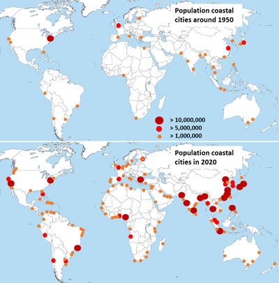
Coastal cities have experienced tremendous growth in recent decades, especially in Africa and Asia [1], see Fig. 1. Whereas in the past coastal zones were sparsely inhabited, vast urban centers have developed in short time. The population of low-lying coastal cities increased from about 360 million in 1990 to about 500 million in 2015[2]. A study of Hooijer and Vernimmen (2021)[3] shows that in 2020, 197–347 million people lived in coastal areas less than 2 m above sea level, of which 59% in tropical Asia and 10% in tropical Africa. An important part of the economy of coastal states is concentrated in these centers. By 2050, two-thirds of the world's population is expected to live in cities and by then an estimated 800 million people will live in more than 570 coastal cities that are vulnerable to a 0.5 meter rise in sea level (WEF, 2019)[4]. According to a study by Kulp and Strauss (2019)[5] considering different emission scenarios, 190-630 million people live on land below projected annual flood levels in 2100. Many coastal cities have grown organically, without proper planning and due attention to the vulnerability that results from their location by the sea. This vulnerability already manifests itself during extreme weather conditions, which go along with flooding, loss of life [6] and damage to the buildings along the coast.
The article Sea level rise describes the consequences of climate change for sea-level rise and the associated increase in the frequency of high water under extreme conditions. It is expected that this frequency will increase by a factor of 100 in many places in the coming century and even more in the following period[7]. Flood risks are not limited to urban areas situated below the high water level at sea; more inland situated areas are also affected because an increasing sea level reduces the discharge capacity of rivers and drainage canals that evacuate river and stormwater to the sea. Without timely measures, the consequences for almost all coastal cities in the world will be dramatic.
The increase in the frequency and severity of floods has a strong disruptive influence on the community and the economy in coastal cities. These risks have been investigated through several studies[8][9] to assess which measures are needed and to determine their urgency, see also section #Most vulnerable cities. Less favorable economic prospects as the risks facing coastal cities increase can prompt declining investments and revenues from industry and tourism and ultimately lead to economic and social disruption[10]. Coastal cities with weak governance, a poor and growing population and a large influx of migrants are particularly sensitive to these risks.
Causes of increasing vulnerability
The causes of increasing vulnerability are multiple and not only related to climate change. A number of important causes that enhance vulnerability to climate change are briefly discussed below.
The geographical setting
Many coastal towns lie in low-lying coastal plains, often near estuaries or lagoons [11][12]. They have grown from first settlements on elevated grounds (dune barrier, rock formation) along the coast. When elevated ground was no longer available, urban expansion took place in surrounding areas: wetlands, marshes or lagoons that were drained or filled up, see Fig. 2. These areas are often below the high-water level of the nearby sea or river and collect water from the surrounding higher grounds in the event of heavy rainfall. They are therefore highly susceptible to flooding. The most vulnerable areas are usually inhabited by families with the least resources and have the greatest population density [13]. Such geographical and social conditions are an important factor for the vulnerability of many major coastal cities and for their sensitivity to climate change.

Soil subsidence
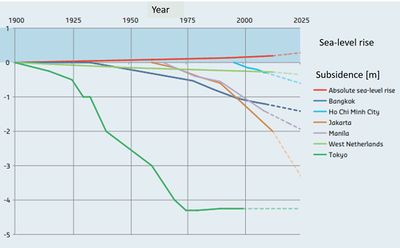
The low-lying coastal areas in which urban expansion has taken place often have a soft soil largely consisting of thick Holocene layers of clay and organic material. Because of the high sensitivity to subsidence, special precautions are required for land use and development. Such precautions are often not met, especially in developing countries[15]. Soft soils cannot bear great weight and therefore require adequate foundations of buildings and infrastructure, which may be lacking. These soils are also susceptible to compaction due to drainage and oxidation. Extraction of groundwater (and in some cases gas or oil) is often the major cause of subsidence. In several coastal megacities, subsidence of several centimeters per year has been measured in places (Fig. 3)[14][16], mainly due to groundwater extraction. Such strong subsidence greatly increases the sensitivity of these areas to flooding.
Groundwater salination
Groundwater is the largest resource of fresh water on earth and constitutes more than 90% of the global fresh water, ice (polar ice and glaciers) excluded. In many regions of the world it is the major source of drinking water and irrigation water, especially in coastal zones[17]. This source is threatened by the intrusion of seawater in coastal aquifers. Seawater intrusion is enhanced by sea level rise, especially in aquifers with low hydraulic gradients[18], see the article Groundwater management in low-lying coastal zones. However, human extraction is a far more important cause in most urbanized coastal areas[19]. A high concentration of salts in drinking water has important adverse impacts on human health[20]. High salt concentrations in irrigation water is detrimental to many crops. Groundwater salination is an imminent economic and social threat in many low-lying coastal zones, for instance the Mekong delta[21].
Population growth
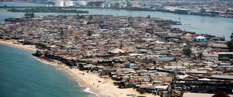
Demographic growth in developing countries is particularly strong in rural areas. Water scarcity, especially in Africa, reduces the availability of suitable agricultural land [22], while mechanization reduces the need for manpower. This makes it difficult for the young generation to earn a living[23]. They flock to the large urban centers along the coast to find employment. Many of them lack education and do not have the means to settle in safe places and often live unregistered in slums in the least safe areas, including the seashore and river banks (illustrated in Fig. 4). The habitants of these areas do not have sanitary facilities, safe drinking water and are the first victims of flooding. They form a highly vulnerable group because, due to their precarious living conditions, they cannot make provisions against the effects of climate change [10].
Water quality
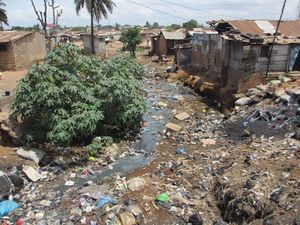
In low-income coastal megacities, it is difficult to provide public facilities for the fast-growing population. This not only concerns protection against flooding, but also waste removal, sewage collection and treatment and safe drinking water[24]. Treatment plants are often defective; they have insufficient capacity or are even completely absent. The discharge of waste from households and industry is poorly regulated and insufficiently enforced. Drainage canals are often obstructed with garbage[13], as illustrated in Fig. 5. This exposes the population to harmful substances that cause diseases and premature death. Higher temperatures increase the risk of infectious diseases. The greatest risks of exposure occur during floods in which waste water is spreading all over the place. Degraded water quality also has a strong negative impact on fishing, which is important for food supply and for employment and income of a substantial part of the population.
Degradation of natural protection
Marshes, mangroves and coral reefs offer natural protection against flooding during extreme weather conditions. The growth of megacities often came at the expense of this natural protection. Wetlands have been reclaimed for urbanization and mangroves have been harvested for timber and to make way for fish ponds[25]. Dunes and beaches are often partially excavated to extract sand for landfill; corals and shell banks are used as raw materials for construction [26]. Although these latter practices are often prohibited, enforcement fails to prevent this. The impoverishment of the natural ecosystem that results from these practices causes a further accelerated deterioration of the protection that nature offers.
Weak governance
Failing governance is a major problem in developing countries. Steering the aforementioned issues is an enormous challenge, in particular the issue of rapid population growth and the mass influx of poorly educated migrants. Tax collection systems often fall short for providing the financial resources needed to cope with the legacy of poor infrastructure and inadequate coastal zone planning and to make necessary investments (including health care and education). There is a lack of well-trained staff and therefore lack of competence within government institutions. The governmental organization is generally weak and institutions do not work well together. Legal provisions are not well aligned with existing problems, legal provisions are not being properly enforced, land ownership rights are unclear, decision-making processes are poorly organized, without proper involvement of civil society and administrative procedures are insufficiently effective[27][28][29][30]. There are often important cultural differences between representatives of different population groups, which hinder standing up for a common interest. The overwhelming amount of short-term problems pushes long-term developments into the background. Therefore, anticipating the effects of climate change does not have the priority that is required.
Most vulnerable cities
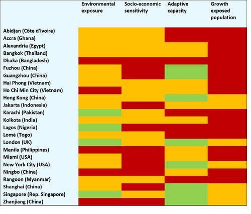
Various lists of highly vulnerable coastal cities have appeared in the literature. The ranking depends on the criteria used. Table 1 gives an (non-exhaustive) overview of coastal cities that are often cited for their vulnerability to climate change. For each coastal city, it is indicated which aspects influence vulnerability the most. The overview is based on an the inventories of the World Wide Fund For Nature (WWF, 2009)[31], Hanson (2011)[32], Neumann et al. (2015)[12], [33], Dhinan et al. (2019)[34], Hallegatte et al. (2013)[32].
The table shows that the exposure to flood risks is already very high in many cities today (existing flood protection measures being taken into account). The consequences of flooding are serious in all cases. Low-income countries are less well organized and have fewer resources than rich countries to take measures for reducing vulnerability. Drainage canals clogged with garbage and squatter settlements on river banks and beaches, as often observed in low-income countries, are indicators of weak governance and low adaptive capacity. Table 1 further shows that without additional measures, there is a strong or very strong increase in flood exposure of the population due to climate change in all coastal cities.
Adaptation measures
An overview of climate adaptation measures is given in the article Climate adaptation measures for the coastal zone. Below we will discuss in more detail measures that are particularly relevant for coastal cities in low-income countries. These measures respond to the vulnerabilities discussed in the previous section #Causes of increasing vulnerability.
Governance
Climate adaptation stands or falls with the ability of administrations to take in time appropriate adaptation measures. Authorities need well-trained staff and therefore have to invest in training and capacity building programs[13]. A major obstacle to risk reduction measures are the high costs and the lack of an immediate tangible effect. Broad support for such measures often arises only after a disaster has occurred. Anticipatory measures that require shared sacrifices will not easily receive broad support in communities where social inequality is strong. However, it is possible to incorporate climate adaptation in measures that deliver direct social benefits, such as: reduction of social inequality through equitable taxes and income redistribution, investments in education and health care, good affordable housing and improvement of the infrastructure for water and sanitation [10]. Measures can be designed such that they contribute to reduce the potential impact of climate change, e.g. by increasing the resilience of citizens, by providing faster and better emergency aid, by building flood-proof homes, by securing critical infrastructure and by preventing the dispersal of hazardous substances[35]. Such measures can be implemented step by step, depending on the resources available. Measures that can be realized at short term are the implementation of organizations for early warning, emergency interventions and rescue. See also the articles Integrated Coastal Zone Management (ICZM) and Climate adaptation measures for the coastal zone.
City planning
City planning is a crucial instrument for increasing the resilience of coastal cities to flooding. City planning must first of all prevent development in zones that are most sensitive to flooding. A very effective measure is the establishment and enforcement of setback areas along the coast and river banks, see the article Setback area. These areas are often already built on and relocating the local population may be needed. This is not easily done and requires not only good alternative housing. The current situation is that residents of unsafe areas often prefer to accept flood risk than give up their home, postponing the need for relocation as long as possible by ad-hoc measures[36]. People who live precariously in vulnerable areas often feel neglected and distrust authorities[13]. To obtain support and cooperation, authorities have to communicate intensively as an understanding, listening and reliable partner with inhabitants in planning and relocation processes.
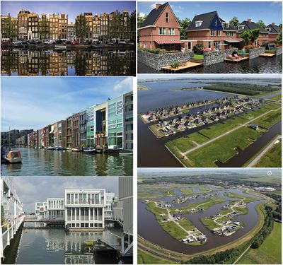
Adaptation of the local infrastructure is necessary to better manage storm and flood water. This can be realized by giving water more space in the city, as illustrated in Fig. 6. In addition, an efficient and well-maintained drainage infrastructure is required. A general planning principle for dealing with storm water and flash floods is[37]:
- space for water retention / absorption upstream of the city,
- space for water storage in the city and
- high-capacity canals / drains for fast water discharge downstream of the city.
Water supply from remote sources must ensure that no groundwater needs to be pumped up, in order to reduce subsidence. Building regulations must ensure that houses are resistant to flooding and that residents can secure themselves on higher floors; existing buildings have to be refitted if necessary. These adaptations are costly and require appropriate funding mechanisms. [38]. A broad spectrum of issues is related to urban water management (see Fig. 7); therefore, an integrated approach is required.
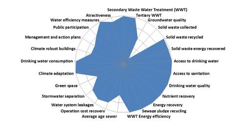 Figure 7: Assessment of policy objectives related to urban water management for the city of Amsterdam[39]. |
Limiting rural exodus
Limiting the migration from the countryside to the urban centers along the coast requires political priority for rural development. Agricultural policy should tackle existing obstacles to rural development. It comprises a broad spectrum of measures, for example, investing in knowledge development and knowledge sharing of efficient modern farming techniques, creating financial mechanisms for their implementation and creating insurance mechanisms against crop failures, regulating land ownership, improving agricultural product marketing mechanisms, stimulating the development of local food processing industries, improving water supply and irrigation practices and investing in infrastructure for transport, warehousing, cold storage and wholesale markets [40]. By reducing migration to urban centers, policies to improve prosperity and economic growth in agricultural areas are therefore an important complement to policies for reducing the vulnerability of coastal towns.
Groundwater management
Arresting or controlling subsidence related to groundwater use requires[41][42]:
- Reduction of groundwater extraction, to bring it in balance with natural and/or artificial recharge. Reduction of groundwater extraction can be achieved by making better use of possibilities of water reuse. Effluents of treatment plants can be used for irrigation, evaporation loss can be reduced by appropriate agricultural practices, irrigation water can be collected in ditches and reused after seepage into the subsoil (as practiced in Egypt). Mixing of reusable water with water of lower quality should in general be avoided. In Hong Kong, seawater is used for toilet flushing[20].
- Managing natural recharge. An important water buffer is provided by storage in the upper meters of soil and in shallow aquifers. Natural recharge is enhanced by ensuring that infiltration can take place in uncovered areas by avoiding the creation of impervious built-up areas and by reducing the discharge velocity of natural streams and increasing the infiltration interface with the aquifer. Restoring ecosystems, protecting biodiversity and gallery forests along the river shore and reforestation also contribute to groundwater recharge. Earthen gully plugs in drainage canals can retain groundwater in large areas – a technique common in the eastern part of India and Bangladesh. Subsurface dams and sand dams have this same effect of retaining groundwater and creating a huge reservoir by increasing the outflow level. Recharge also benefits from landscape elements that slow down and retain surface run-off such as terraces, low bunds, depressions, and cleverly designed roads and canal embankments. Sophisticated subsurface drainage systems - networks of collectors and distributors equipped with special valves and outlets - make precision groundwater level management possible.
- Artificial recharge can range from individual rooftop rainwater harvesting systems, small storage solutions and recharge wells to water harvesting at catchment level. Both the artificial recharge of aquifers from the land surface and the repressuring of aquifers through wells require a supply of good quality surface water. An alternative is the reuse of treated municipal wastewater of sufficient quality. The local geologic conditions (presence of confining aquitards) determine whether artificial recharge can be accomplished by regulated application at the land surface or by repressuring of aquifers by means of injection through wells. Sub-surface storage has several advantages including low evaporation losses, relative protection against water pollution, and improved water quality as the soil can reduce acidity, remove inorganic and organic compounds through adsorption while chemical as well as biological processes can change and neutralize hazardous compounds.
- Groundwater management practices to reduce salt intrusion in aquifers and to avoid salt water upconing in pumping wells are discussed in the article Groundwater management in low-lying coastal zones.
The experience of Shanghai shows that measures to arrest subsidence (ban on groundwater extraction and artificial recharge) take effect only several years after implementation[43].
Protection against flooding from the sea
Sea level rise is a major threat to coastal cities worldwide[44]. Large parts of many coastal cities are situated today below the water level reached at sea during a 1/100 storm[45][32]; the frequency of exceedance of these storm levels may increase by a factor 10 or 100 during the 21st century[46][7]. Constructions to protect against flooding and overtopping waves have to be adapted accordingly.
Different types of constructions can be considered for protection against flooding from the sea. Hard structures are used most often. An overview of such constructions with criteria of application, advantages and drawbacks can be found in several articles in the category Hard structures. The costs of coastal defenses depend on the intended level of protection, i.e. the size and strength of the structure required to keep the probability of flooding below a certain value. An overview of cost estimates is given in Jonkman et al. (2013)[47] and Aerts (2018)[48]. The costs for ensuring a high level of protection are considerable, but in many cases much lower than the avoided costs of damage in the event of flooding[32]. Costly defense measures can also be justified to protect people and to avoid strong social impacts[12]. Some highly exposed coastal cities are listed in Table 1, but this list is far from exhaustive.
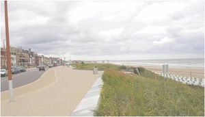
Soft coastal defense options have become more popular in recent decades, see the articles in the category Soft coastal interventions and some examples in the article Climate adaptation measures for the coastal zone. These soft measures are usually more resilient and easier to maintain, but cannot be used everywhere, e.g. because materials are not available or because space is insufficient. Van Coppenolle and Temmerman (2019) [49] have made an inventory of the potential of coastal cities to implement soft coastal protection measures, showing that this is a feasible option for many coastal cities. An example of an artificial dune as soft coastal protection measure is shown in Fig. 8. Other soft nature-based coastal protection measures, such as mangroves, marshes or reefs, can provide cost-effective solutions to reduce the wave impact on urbanized coasts[50], see also the articles Nature-based shore protection and Shore protection vegetation.
Examples of responses to increased flood risks
Bangkok
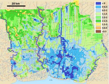
The Bangkok metropole with over 14 million inhabitants is situated in the wide coastal plain of the Chao Phraya river. The elevation of the tidal lowland in the southernmost region is around 1 m above mean sea level (i.e. below high tide level) and its surface is very flat and low (Fig. 9). The deltaic plain with elevation 2- 3 m has been formed as a tidal and deltaic plain since the Holocene high stand around 6000 years BP. The surface sediments are soft silt of marine origin. Drainage conditions are poor because the surface gradient of the region is very low and the relative gradient of the drainage is decreasing as a result of sea level rise[51].
- More frequent and severe floods resulting from extreme river run-off and sea level rise
- Flooding has been become worse during the past decades due to rapid soil subsidence induced by massive groundwater extraction and due to the replacement of canals and urban water spaces by roads and buildings, see Fig. 3.
- Ineffectiveness of the flood drainage system
- Fast shoreline retreat[55]
- Groundwater salination[20]
Responses
- Construction of dams and reservoirs, discharge canals, dikes (levees) and polder systems, installation of pumps
- Upgrading existing drainage systems to improve the urban flood defence system
- Flood retarding in the upstream river reaches by diverting water toward temporary water retention areas
- Developing new water storage capacity inside the city by creating open spaces and green areas as water potential storage areas
- Improved irrigation- and hydropower reservoir management
- Mangrove restoration
- Improving community-based adaptation and disaster preparedness and communication
- Enhancing emergency preparedness and response through monitoring and communication
- Capacity building for disaster risk reduction
Sponge Cities initiative in China
A 'Sponge City' is a city that has the capacity to integrate urban flood risk management into its urban planning policies and designs, based on appropriate planning and legal frameworks and tools. Sponge cities implement, maintain, and adapt their infrastructure systems to collect, store, and purify (excess) rainwater. A Sponge City will not only be able to deal with too much water, but will also re-use rain water to reduce the impacts of drought. The anticipated benefits of a Sponge City are [56]:
- a reduction of the economic losses due to flooding;
- an enhancement of the livability of cities, and
- the establishment of an environment where investment opportunities in infrastructure upgrading and engineering products and new technologies are created and fostered.
In China, 16 pilot cities were selected to become Sponge Cities, including the coastal megacities of Tianjin, Shanghai, and Shenzhen. The Directive on promoting Sponge City Construction of 2015 sets the target that 20% of the urban areas of Chinese cities should absorb, retain, and re-use 70% of the rainwater by 2020. By 2030, this percentage should rise to 80%. The general objectives of the concept are:
- restoring the city’s capacity to absorb, infiltrate, store, purify, drain, and manage rainwater and
- regulating the water cycle as much as possible to mimic the natural hydrological cycle.
Mumbai
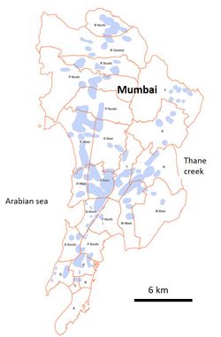
Mumbai city was formed by the reclamation of water-logged areas between the seven separate former islands. The reclaimed space between the islands lies below the high water level. Whenever the rainfall persists for a longer time (7–10 h) and coincides with the time of high tides, water cannot be evacuated into the ocean and the low-lying areas are flooded (see Fig. 10). More than half of the population of Mumbai live in squatter settlements, mostly in the flood-prone areas, rendering this low-income group more vulnerable to the perils of the recurring floods. The yearly flooding in Mumbai incurs huge economic losses due to the economical–social disorientation and associated shutdown, ultimately affecting the nation’s economy[34][57][58].
Issues
- Regular flooding during the monsoon period
- Outdated inappropriate drainage system; outflow capacity decreased by sea level rise
- Land-use/land-cover changes, land reclamation, uncontrolled urbanization, rivers channel modification, encroachment of the floodplain and embankments with illegal settlements
- Loss of water infiltration areas
- Citizen attitudes and behaviour leading to siltation and obstruction of drainage channels, inadequate waste management system, contamination of freshwater resources
- Lack of coordination among various governmental agencies
Responses
- Mithi river bed restoration plan. The river is choked with plastic wastes and is devoid of a floodplain because of the encroachment with illegal settlements
- Prevent waste and sewage clogging of Mumbai’s waterways
- People or community-centered activities from informal settlements structural adjustments, support networks after flood events
Jakarta
Jakarta, capital of Indonesia, is among the most densely urbanized and most vulnerable coastal megacities in the world. This vulnerability is due, on the one hand, to the massive land conversions of rivers, canals, and wetlands, reducing flood retention and discharge capacities, and on the other hand, to land subsidence at rates of up to 25 cm per year (Fig. 3), mainly driven by groundwater extraction. The potential extent of the areas affected by coastal flooding in Northern Jakarta could expand by 110.5 km2 by 2050, mostly as a consequence of the ongoing land subsidence (which would account for 88% of this increase)[59][60].
Issues
- Increased frequency and severity of flooding resulting from land subsidence and sea level rise
- Main factors driving subsidence: (1) massive—mostly uncontrolled—groundwater extraction for private and industrial purposes; (2) the natural sediment compaction which is not compensated for due to the interruption of natural sedimentation replenishment; and (3) the substantial compaction loads from buildings and other infrastructure
Responses
- River and canal regulation, the broadening of water ways and the clearance of river banks, which are frequently encroached by informal settlers
- Upgrades and expansions to the existing flood protection infrastructures in the city, foremost the retention reservoirs, drainage canals, flood protection walls along the main waterways and the coastal dam
- Informal small-scale adaptation measures including individual as well as collective measures, e.g., adding more levels to buildings, raising floors, constructing barriers using bricks or wood to prevent floodwater from entering, constructing small-scale water barriers around settlements (however, empirical analysis has shown that these measures are limited in effectiveness to combat the larger floods and their trend towards intensification[59])
- A new coastal flood protection wall, the 'Giant Seawall' also known as 'Great Garuda Project'
- Moving the national capital from Jakarta to East Kalimantan on Borneo Island
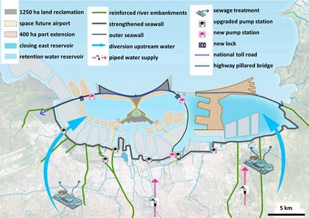
The 'Giant Seawall' is a dike with a length of 25 km that turns Jakarta Bay into an enclosed reservoir, with a pumping station of 730 m3/s for discharging peak river runoff (Fig. 11). The financing of the project (estimated at more than 40 billion US$) is based on the estimated revenues derived from the development of new estates for commercial and residential purposes on reclaimed islands in Jakarta Bay[61]. The project is controversial, however, because of its potential impacts on the environment (pollution, sedimentation, ecology) and on small-scale fishing and aquaculture on which many poor households rely. There are also concerns that the project will increase the gap between the haves and have-nots in the city, that it does not tackle the root of the vulnerability issue and that it is inflexible for responding to future uncertain economic and environmental developments. It is not yet certain that the project will be completed. Great Garuda is the first large-scale adaptation project designed to protect a coastal megacity against the threat of relative sea-level rise. The technical, economic and social issues addressed in this project therefore offer highly relevant lessons for other coastal megacities [59].
Manila
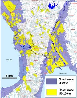
Metro Manila’s environmental risks include floods and coastal inundation (Fig. 12) brought about by sea-level rise and the increasing intensity and irregularity of typhoons (an average of 20 typhoons annually), storm surges and monsoon rains[62]. Being situated on several fault lines, metro Manila is also at risk of earthquakes. Metro Manila’s population expanded from 6 million in 1980 to 8 million in 1990, 10 million in 2000 and 14 million in 2020. The ability of government agencies to impose building and infrastructure standards is weak; the growth and expansion of informal settlements have therefore gone largely unregulated. Many buildings and infrastructure are built in danger zones (e.g., near the seashore or flood zones, unstable and landslide-prone ground, etc.) without permits[60].
Issues
- Extreme floods during the monsoon season exacerbated by tropical cyclones
- Natural drainage restricted during rainfall by high river and seawater levels
- Drainage system impaired by solid waste accumulation in drainage channels and pumping stations
- Land subsidence that has contributed to increasing relative sea level rise by 0.4 m
- Intense development in areas with high soil subsidence/siltation, swampy areas/wetlands that are heavily inhabited
Responses
- Investments in flood defense structures: dikes, river embankments, improvement of waterways, modernization of the drainage infrastructure and pumping stations
- Increasing the water retention capacity, e.g. green and other infrastructure such as rooftop rainwater collection, green roofs, permeable pavements, and temporary retention of drainage water in public areas such as basketball courts and parking garages
- Upstream water retention ponds
- Solid waste collection
- Households in vulnerable areas adapt to flooding by raising floors and adding more floors to their dwellings
- Flood forecasting and early warning systems and community-based flood risk management
- Improved institutional structure to deal with flood management
- Relocation of the informal settlers from the most vulnerable neighbourhoods (inhabited by the poorest people with limited adaptation capacity)
Ho Chi Minh City (HCMC)
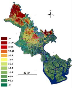
Ho Chi Minh City is located on the north-eastern edge of the Mekong Delta, downstream from the Saigon-Dong Nai River. The Saigon River Basin is a complex hydrological system, characterized by about 8000 km of interconnected rivers and canals, extensive low-lying marshlands, and seasonally extreme rainfalls. About 65% of the city is less than 1.5 m above mean sea level (Fig.13). In the French colonial period, the urban core of HCMC was built on higher areas (4–10 m above mean sea level), presently located in the urban center. HCMC has been expanding rapidly, with a population increase of 2 million in 1970, to 3 million in 1990, to 5 million in 2004 and 9 million people in 2022. Shortage of space pushed new urban development to lower elevation areas beyond the city center which face high flood exposure[64][60].
Issues
- HCMC suffers from flooding several times per year caused by high river run-off, high tides or a combination of both
- Land subsidence due to groundwater extraction and diminished natural aquifer recharge
- Localized flooding due to urban development that has decreased rain water infiltration and increased surface run-off
Responses
- Formal adaptation measures that considers future sea level rise, flood control plan aiming to ensure the safety of 570 km2 of the core urban areas (populated by 6.5 million people) that includes the building of ring dikes, sluice flood gates, drainage canals and pumping stations to control the water level inside the city
- Informal measures by local residents to protect their houses using their own resources, which include using pumps, building barriers, moving furniture to higher elevation, and raising floors or even rebuilding their entire houses
Related articles
- Climate adaptation policies for the coastal zone
- Climate adaptation measures for the coastal zone
- Integrated Coastal Zone Management (ICZM)
- Groundwater management in low-lying coastal zones
References
- ↑ 1.0 1.1 Barragan, J.M. and de Andres, M. 2015. Analysis and trends of the world's coastal cities and agglomerations. Ocean & Coastal Management 114; 11-20
- ↑ MacManus, K., Balk, D., Engin, H., McGranahan, G. and Inman, R. 2021. Estimating population and urban areas at risk of coastal hazards, 1990–2015: How data choices matter. Earth System Science Data 13: 5747–5801
- ↑ Hooijer, A. and Vernimmen, R. 2021. Global LiDAR land elevation data reveal greatest sea-level rise vulnerability in the tropics. Nature Communications 12: 3592
- ↑ WEF 2019. The Global Risks Report 2019, 14th Edition. World Economic Forum
- ↑ Kulp, S.A. and Strauss, B.H. 2019. New elevation data triple estimates of global vulnerability to sea-level rise and coastal flooding. Nature Communications 10:4844
- ↑ Jonkman, S.N. and Vrijling, J.K. 2008. Loss of life due to floods. J Flood Risk Management 1: 43–56
- ↑ 7.0 7.1 IPCC, 2019. Special Report on the Ocean and Cryosphere in a Changing Climate [Eds.: H.-O. Pörtner, D.C. Roberts, V. Masson-Delmotte, P. Zhai, M. Tignor, E. Poloczanska, K. Mintenbeck, M. Nicolai, A. Okem, J. Petzold, B. Rama and N. Weyer]
- ↑ OECD report 2010 Coastal Cities and Climate Change https://www.oecd.org/env/cities-and-climate-change-9789264091375-en.htm
- ↑ Kerezci, E., Young, I.R., Ranasinghe, R., Muis, S., Nicholls, R.J., Lincke, D. and Hinkel, J. 2020. Projections of global‑scale extreme sea levels and resulting episodic coastal flooding over the 21st Century. Nature Scientific Reports 10:11629
- ↑ 10.0 10.1 10.2 Vivekananda, J. and Bhatiya, N. 2016. Coastal Megacities vs. the Sea: Climate and Security in Urban Spaces. BRIEFER 30: 1-12 Cite error: Invalid
<ref>tag; name "VB" defined multiple times with different content - ↑ McGranahan, G., Balk, D. and Anderson, B. 2006. The rising tide: assessing the risks of climate change and human settlements in low elevation coastal zones. Environ Urban 12: 17–38
- ↑ 12.0 12.1 12.2 Neumann, B., Vafeidis, A. T., Zimmermann J. and Nicholls, R. J. 2015. Future coastal population growth and exposure to sea-level rise and coastal flooding – a global assessment. PLOS ONE 10: 1-34
- ↑ 13.0 13.1 13.2 13.3 Douglas, I., Alam, K., Maghenda, M., McDonnell, Y., McLean, L. and Campbell, J. 2008. Unjust waters: climate change, flooding and the urban poor in Africa. Environment & Urbanization, International Institute for Environment and Development (IIED) 187: 187–205. DOI: 10.1177/0956247808089156
- ↑ 14.0 14.1 Deltares, Sinking cities https://www.deltares.nl/app/uploads/2015/09/Sinking-cities.pdf
- ↑ Dinar, A., Esteban, E., Calvo, E., Herrera, G., Teatini, P., Tomas, R., Li, Y., Ezquerro, P. and Albiac, J. 2021. We lose ground: Global assessment of land subsidence impact extent. Science of the Total Environment 786: 147415
- ↑ Syvitski, J.P.M., Kettner, A.J., Overeem, I., Hutton, E.W.H., Hannon, M,T., Brakenridge, G.R., Day, J., Vörösmarty, C., Saito, Y., Giosan, L. and Nicholls, R.J. 2009. Sinking deltas. Nature Geoscience volume 2: 681–686
- ↑ Post, V. E. A. 2005. Fresh and saline groundwater interaction in coastal aquifers: Is our technology ready for the problems ahead? Hydrogeol. J. 13: 120-123
- ↑ Ketabchi H., Mahmoodzadeh, D., Ataie-Ashtiani, B. and Simmons, C.T. 2016. Sea-level rise impacts on seawater intrusion in coastal aquifers: review and integration. J. Hydrol. 535: 235-255
- ↑ Ferguson, G. and Gleeson, T. 2012. Vulnerability of coastal aquifers to groundwater use and climate change. Nat Clim Change 2: 342-345
- ↑ 20.0 20.1 20.2 Lassiter, A. 2021. Rising seas, changing salt lines, and drinking water salinization. Current Opinion in Environmental Sustainability 50: 208–214
- ↑ Xiao, H., Tang, Y., Li, H., Zhang, L., Ngo-Duc, T. Chen, D. and Tang, Q. 2021. Saltwater intrusion into groundwater systems in the Mekong Delta and links to global change. Advances in Climate Change Research 12: 342-352
- ↑ Koutroulis, A.G., Papadimitriou, L.V., Grillakis, M.G., Tsanis, I.K., Warren, R. and Betts, R.A. 2019. Global water availability under high-end climate change: A vulnerability based assessment. Global and Planetary Change 175: 52–63
- ↑ Seto, K.C., 2011. Exploring the dynamics of migration to mega-delta cities in Asia and Africa: contemporary drivers and future scenarios. Global Environ. Change 21: S94-S107
- ↑ Penning de Vries, F.W.T., Acquay, H., Molden, D., Scherr, S.J., Valentin, C. and Cofie, O. 2002. Integrated Land and Water Management for Food and Environmental Security. Global Environmental Facility. Comprehensive Assessment Research Paper Colombo, Sri Lanka
- ↑ Agardy, T. and Alder, J. (lead authors) 2005. Millennium Ecosystem Assessment Chapter 19 Coastal Systems. Washington, D.C., Island Press
- ↑ Wilkinson, C. 2001. Status of coral reefs of the world 2000. Queensland (Australia): Australia Institute of Marine Science
- ↑ Diop, S. and Scheren, P.A. 2016. Sustainable oceans and coasts: Lessons learnt from Eastern and Western Africa. Estuarine, Coastal and Shelf Science 183: 327-339
- ↑ Tabet, L. and Fanning, L. 2012. Integrated coastal zone management under authoritarian rule: An evaluation framework of coastal governance in Egypt. Ocean & Coastal Management 61: 1-9
- ↑ Le, T.D.N. 2019. Climate change adaptation in coastal cities of developing countries: characterizing types of vulnerability and adaptation options. Mitigation and Adaptation Strategies for Global Change, https://doi.org/10.1007/s11027-019-09888-z
- ↑ Varis, O. 2006. Megacities, development and water. Int. J.Water Resour. Dev. 22: 199-225
- ↑ WWF 2009. Mega-Stress for Mega-Cities, A Climate Vulnerability Ranking of Major Coastal Cities in Asia
- ↑ 32.0 32.1 32.2 32.3 Hanson, S., Nicholls, R., Ranger, N., Hallegatte, S., Corfee-Merlot, J., Herweyer, C. and Chateau, J. 2011. A global ranking of port cities with high exposure to climate extremes. Climatic Change 104: 89–111 Cite error: Invalid
<ref>tag; name "Ha" defined multiple times with different content - ↑ Wang, G., Liu, Y., Wang, H. and Wang, X. 2014. A comprehensive risk analysis of coastal zones in China. Estuarine, Coastal and Shelf Science 140: 22-31
- ↑ 34.0 34.1 Dhiman, R., Vishnu Radhan, R., Eldho, T. I. and Inamdar, A. 2019. Flood risk and adaptation in Indian coastal cities: recent scenarios. Applied Water Science 9:5
- ↑ Das Neves, L., Bolle, A. and De Nocker, L. 2023. Cost-benefit-analysis of coastal adaptation strategies and pathways. A case study in West Africa. Ocean and Coastal Management 239, 106576
- ↑ Esteban,M., Takagi, H., Jamero, L., Chadwick, C., Avelino, J.E., Mikami, T., Fatma, D., Yamamoto, L., Thao, N.D., Onuki, M., Woodbury, J., Valenzuela, V.P.B. and Crichton, R.N. 2020. Adaptation to sea level rise: Learning from present examples of land subsidence. Ocean and Coastal Management 189, 104852
- ↑ Hillen, M.M. and Dolman, N. 2015. Towards water adaptive cities. World Engineers Summit on Climate Change (WES) July 2015, Singapore
- ↑ Satterthwaite, D., Huq, S., Pelling, M., Reid, H. and Lankao, P. R. 2007. Adapting to Climate Change in Urban Areas. IIED, Rockefeller Foundation. www.iied.org/pubs/display.php?o=10549IIED
- ↑ Koop, S. H. A., and Van Leeuwen, C. J. 2015. Assessment of the Sustainability of Water Resources Management: A Critical Review of the City Blueprint Approach Water Resources Management 29: 5649-5670
- ↑ FAO 2017. The State of Food and Agriculture - leveraging food systems for inclusive rural transformation. http://www.fao.org/3/a-i7658e.pdf
- ↑ Poland, J.F. 1984. Guidebook to Studies of Land Subsidence Due to Groundwater Withdrawal. UNESCO, Paris (305 pp.)
- ↑ van Steenbergen, F. and Tuinhof, A. 2010. Transforming Landscapes Transforming Lives. The business of sustainable water buffer management. ISBN: 978-90-79658-03-9
- ↑ Li, M-G., Chen, J-J., Xu, Y-S., Tong, D-G., Cao, W-W. and Shi, Y-J. 2021. Effects of groundwater exploitation and recharge on land subsidence and infrastructure settlement patterns in Shanghai. Engineering Geology 282, 105995
- ↑ Wong, P.P., I.J. Losada, J.-P. Gattuso, J. Hinkel, A. Khattabi, K.L. McInnes, Y. Saito, and A. Sallenger 2014. Coastal systems and low-lying areas. In: Climate Change 2014: Impacts, Adaptation, and Vulnerability. Part A: Global and Sectoral Aspects. Contribution of Working Group II to the Fifth Assessment Report of the Intergovernmental Panel on Climate Change [Field, C.B., V.R. Barros, D.J. Dokken, K.J. Mach, M.D. Mastrandrea, T.E. Bilir, M. Chatterjee, K.L. Ebi, Y.O. Estrada, R.C. Genova, B. Girma, E.S. Kissel, A.N. Levy,S. MacCracken, P.R. Mastrandrea, and L.L. White (eds.)]. Cambridge University Press, pp. 361-40
- ↑ Muis, S., Verlaan, M., Winsemius, H.C., Aerts, J.C.J.H. and Ward, P.J. 2018. A global reanalysis of storm surges and extreme sea levels. Nat. Commun. 7:11969
- ↑ Vousdoukas, M.I., Mentaschi, L., Voukouvalas, E., Verlaan, M., Jevrejeva, S., Jackson, L.P. and Feyen, L. 2018. Global probabilistic projections of extreme sea levels show intensification of coastal flood hazard. Nature communications, 9 (1), 2360
- ↑ Jonkman, S.N., Hillen, M.M., Nicholls, R.J., Kanning, W. and van Ledden, M. 2013. Costs of adapting coastal defences to sea-level rise—New estimates and their implications. J. Coast. Res. 29: 1212–1226
- ↑ Aerts, J.C.J.H. 2018. A Review of Cost Estimates for Flood Adaptation. Water 10, 1646
- ↑ Van Coppenolle, R, and Temmerman, S. 2019. A global exploration of tidal wetland creation for nature-based flood risk mitigation in coastal cities. Estuarine, Coastal and Shelf Science 226, 106262
- ↑ Narayan, S., Beck, M., Reguero, B., Losada, I., Van Wesenbeeck, B., Pontee, N., Sanchirico, J., Ingram, J., Lange, G. and Burks-Copes, K. 2016. The Effectiveness, Costs and Coastal Protection Benefits of Natural and Nature-Based Defences. PLoS ONE 11, e0154735
- ↑ Umitsi, M. 2000. Geo-environment and effect of sea level rise in the Chao Phraya Delta. Procs. Int. Conf. The Chao Phraya Delta: Historical Development, Dynamics and Challenges of Thailand's Rice Bowl, Bangkok, vol. I, pp. 152-158
- ↑ Resilient Bangkok. 100 Resilient Cities. https://resilientcitiesnetwork.org/downloadable_resources/Network/Bangkok-Resilience-Strategy-English.pdf
- ↑ Thanvisitthpon, N., Shrestha, S. and Pal, I. 2018. Urban Flooding and Climate Change: A Case Study of Bangkok, Thailand. Environment and Urbanization. Asia 9: 1–15
- ↑ Jarupong Pengglieng 2017. Bangkok : Climate Change Management. Urban Regeneration and Climate Change Training Program 18 - 22 September 2017. https://www.metropolis.org/sites/default/files/09.urban_management_thailand_bangkok.pdf
- ↑ Bidorn, B., Sok, K., Bidorn, K. and Burnett, W.C. 2021. An analysis of the factors responsible for the shoreline retreat of the Chao Phraya Delta (Thailand). Science of the Total Environment 769, 145253
- ↑ Zevenbergen, C., Fu, D. and Pathirana, A. 2018. Transitioning to Sponge Cities: Challenges and Opportunities to Address Urban Water Problems in China. Water 10, 1230; doi:10.3390/w10091230
- ↑ Dhiman, R., Kalbar, P. and Inamdar, A.B. 2019. Spatial planning of coastal urban areas in India: Current practice versus quantitative approach. Ocean & Coastal Management 182, 104929
- ↑ Ghosh, A., Boyd, E. and Boykoff, M. 2015. Climate change adaptation in Mumbai, India. In: The Urban Climate Challenge: Rethinking the Role of Cities in the Global Climate Regime, Ch. 8. Routledge
- ↑ 59.0 59.1 59.2 Garschagen, M., Surtiari, G.A.K. and Harb, M. 2018. Is Jakarta’s New Flood Risk Reduction Strategy Transformational? Sustainability 10, 2934
- ↑ 60.0 60.1 60.2 Cao, A., Esteban, M., Valenzuela, V.P.B., Onuki, M., Takagi, H., Thao, N.D. and Tsuchiya, N. 2021. Future of Asian Deltaic Megacities under sea level rise and land subsidence: current adaptation pathways for Tokyo, Jakarta, Manila, and Ho Chi Minh City. Current Opinion in Environmental Sustainability 50: 87–97
- ↑ Wade, M. 2019. Hyper-planning Jakarta: The Great Garuda and planning the global spectacle. Singapore Journal of Tropical Geography 40: 158–172
- ↑ Porio, E. 2014. Climate Change Vulnerability and Adaptation in Metro Manila Challenging Governance and Human Security Needs of Urban Poor Communities. Asian Journal of Social Science 42: 75–102
- ↑ Nhat, T.T. 2014. Improvement of flood risk assessment under climate change in Ho Chi Minh City with GIS applications. PhD Thesis Brandenburg University of Technology
- ↑ Leitold, R., Garschagen, M., Tran, V. and Revilla Diez, J. 2021. Flood risk reduction and climate change adaptation of manufacturing firms: Global knowledge gaps and lessons from Ho Chi Minh City. International Journal of Disaster Risk Reduction 61:102351
Please note that others may also have edited the contents of this article.
|
