Groundwater management in low-lying coastal zones
Groundwater is a crucial resource for drinking water and irrigation in many coastal regions. However, groundwater extraction in low-lying coastal zones is problematic. It raises the salinity of the groundwater and causes the land to sink. In coastal zones with a high population density, fresh groundwater resources are often overexploited. The quality of the resource is threatened by contamination from industrial, urban and agricultural effluents. Nitrate contamination of submarine groundwater discharge can be highly damaging for coastal ecosystems[1]. Climate change is becoming a serious issue[2]. Sea level rise leads to increasing seawater intrusion into the coastal aquifer, while changing precipitation patterns alter fresh water recharge. Groundwater management in low-lying coastal areas therefore requires a long-term strategy based on sound knowledge of the underlying physical processes. Natural conditions - meteorology, hydrology, seawater intrusion, tides - and human activities - land use, pumping, effluents - all influence groundwater flow, groundwater quality and subsurface structure. Simulations with mathematical models have to deal with the variability of these processes on vastly different time scales. Their predictive performance is further limited by the great heterogeneity of the subsurface, which is rarely known in detail.[3] This article explains the most important processes and gives some practical examples of groundwater management.
Contents
- 1 Threats of groundwater extraction
- 2 Salt intrusion processes
- 3 Groundwater management
- 4 Measures to reduce soil and groundwater salinization
- 5 Dealing with brackish groundwater
- 6 Groundwater modelling and observation
- 7 Appendix A: The SeepCat system
- 8 Appendix B: Seawater intrusion length derivation
- 9 Related articles
- 10 Further reading
- 11 References
Threats of groundwater extraction
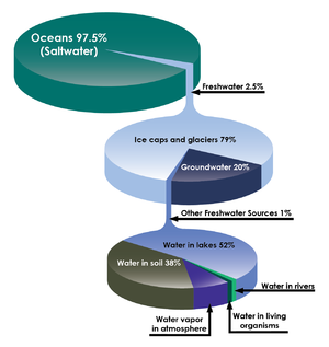
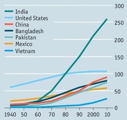
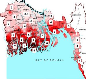
Fresh water represents only a small fraction of earth's water resource – less than 1%, ice excluded (Fig. 1). Groundwater is by far the most important fresh water resource available for human use. More than 50% of world’s population lives in coastal areas and is largely dependent on fresh groundwater resources for domestic, agricultural and industrial purposes. The exploitation of fresh groundwater resources is sharply increasing as a consequence of population growth, economic growth, intensified agricultural development, and the degradation of surface water resources due to contamination (Figs. 2,3).
Worldwide, many large coastal cities have expanded into low coastal plains during the past decades, especially in Asia and Africa (see Coastal cities and sea level rise). Most of these plains emerged after the Holocene marine transgression, when the seabed was raised above sea level by sedimentation behind a sheltering coastal barrier. These deposits form a top soil layer of a few meters up to several tens of meters thick, and contain a high fraction of fine sediments of fluvial and marine origin (and peat, in humid climatic zones). On these poorly draining soils, which are highly susceptible to compaction, extensive urban and industrial development has taken place[6]. The land elevation is generally close to the mean high sea level. However, in many areas it is lower and still subsiding, mainly as a result of drainage and groundwater extraction[7].
Intensive groundwater extraction from underlying water-bearing layers (aquifers) stimulates the intrusion of seawater, leading to increased groundwater salinity[9]. In the lowest areas, brackish groundwater may reach the surface by upward groundwater flow through the confining top layer, so-called 'saline seepage'. The threats of uncontrolled groundwater extraction can remain unnoticed for many years because groundwater flow is a slow process. However, in the long run they are considerable [10]:
- unsuitability of groundwater for drinking water,
- reduced usability of groundwater for irrigation,
- soil salinization detrimental to crop growth,
- soil subsidence and increased vulnerability to flooding,
- deterioration of the foundation of buildings by corrosion of concrete, reinforcement and bricks,
- danger of collapse of buildings due to soil instability.
In addition, the anticipated sea level rise and the decrease of recharge, due to climate change and increased water demand in the upstream catchment areas, will further exacerbate the pressures on coastal groundwater systems.
Salt intrusion processes
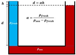
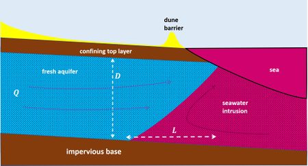
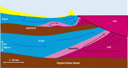
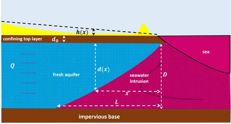
Seawater intrudes into the underground of the coastal plain through aquifers, permeable soil layers consisting of medium / coarse granular material or porous / fissured rock. Due to its greater density, seawater enters like a wedge that pushes fresh water inshore, see Fig. 5. A counter-pressure is exerted by the inshore fresh water table. Due to the small density difference, a small elevation of the fresh water head is sufficient to keep the seawater intrusion in balance, see Fig. 4. This principle was first discovered by Badon-Ghyben and Herzerg and is commonly referred to as the BGH principle. In Fig. 5 it is assumed that the permeability of the underground is the same everywhere. In reality, however, this is never the case due to the presence of poorly permeable layers (aquitards); Fig. 6 shows a still much simplified but slightly more realistic image. A rough estimate of the intrusion length [math]L[/math] of the seawater wedge into a shallow confined aquifer is given by [11],
[math]L \approx k D^2 / (2 \alpha Q) , \qquad (1)[/math]
where [math]\alpha \approx 40[/math] is the inverse relative density difference, [math]k[/math] is the hydraulic conductivity (related to the permeability), [math]D[/math] is the aquifer depth and [math]Q[/math] is the fresh groundwater discharge to the sea per unit width. This formula applies to a homogeneous confined aquifer of constant depth. See appendix B for a derivation.
Equation (1) shows that seawater intrusion depends on aquifer properties ([math]k, D[/math]) and on the fresh groundwater discharge [math]Q[/math] to the sea. The seawater intrusion [math]L[/math] length is greater for aquifers with high permeability than with low permeability. High permeability is associated with coarse-grained sediment or fractured rock, for which the hydraulic conductivity [math]k[/math] is on the order of 10-3 - 10-1 m/s. Aquitards (confining layers) have very low permeability, often associated with indurated clay or peat layers, for which the hydraulic conductivity is on the order of 10-8 - 10-6 m/s. The seawater intrusion length increases with decreasing discharge [math]Q[/math]. The fresh groundwater discharge is related to the inland slope of the piezometric head (= hydraulic head), according to Darcy's law, see appendix B. In steep-sloping coastal zones the hydraulic head slope can be large, but this is not the case for low-lying coastal zones where no large head differences can build up due to the absence of relief. This implies that the seawater length is generally much greater in low-lying coastal zones than in high-relief coastal zones.
The sea level is variable due to tidal motion and wind set-up / set-down and the inland fresh water table varies over the seasons in response to variable fresh water runoff, evapotranspiration and extractions. The resulting fluctuations in the groundwater pressure gradient, together with spatial inhomogeneities in the geologic structure, contribute to mixing across the fresh-salt interface [12]. Several processes can contribute to increase of the seawater intrusion into the coastal aquifer: flooding by the sea, shoreline retreat, sea level rise and decrease of the flux of fresh groundwater to the sea, for example as a consequence of groundwater seepage or groundwater abstraction in the coastal zone. These processes will be discussed in the following sections.
Marine transgression
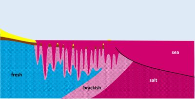
Many coastal areas, especially river deltas, were flooded by the sea during the Holocene transgression, before sedimentation raised the seafloor above mean high water level and before fluvial processes became dominant. The present saline groundwater was largely formed during this period. Saline intrusion in coastal aquifers by marine flooding occurs today only incidentally under extreme storms. Such extreme conditions are rare, but they are expected to become much more frequent in future as a consequence of sea level rise (see Sea level rise) and land subsidence. The process of seawater infiltration in a fresh aquifer resulting from a marine flood is shown in Fig. 7. Increased groundwater salinities may persist many years after such flood events[13]. Floods caused by tsunamis and flooding in the context of depoldering projects have similar effects on the salinization of groundwater.
Sea level rise
The seawater intrusion length increases as the sea level rises. This will happen when low-lying parts of the coastal zone are flooded more often. But the salt intrusion length will also increase in low coastal areas where flooding is prevented by dunes or dikes. This is mainly due to the increased hydraulic head at the seaward boundary, which reduces the inland hydraulic gradient (i.e. decrease of the inland slope [math]s[/math] of the piezometric head [math]h(x)[/math], see Fig. B1). A rough estimate of the increase [math]\Delta L[/math] of the seawater intrusion length is given by [math]\Delta L / L \approx \Delta s / s[/math], where [math]\Delta s[/math] is the decrease of the inland hydraulic gradient[2]. The slope reduction can be significant in low-lying coastal areas where the relief is insufficient for an increase of the inland groundwater head. In these cases, sea level rise causes a reduction in mean groundwater runoff to the sea and a corresponding increase in mean surface runoff. Greater seawater intrusion will ensue, according to Eq. (1). In other situations, the influence of human groundwater abstractions probably dominates the influence of sea level rise[14].
Seawater intrusion via estuaries
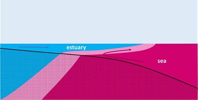
Coastal aquifers are not only in contact with salt water at the land-sea boundary but often also with salt water of estuaries. In this way, intrusion of saline surface water into shallow groundwater can take place further inland (Fig. 8). The intrusion of seawater in estuaries is discussed in the articles Seawater intrusion and mixing in estuaries and Estuarine circulation. Seawater intrusion in estuaries has strongly increased during the past century due to channel deepening (dredging) for navigational purposes and the decrease of river discharges into estuaries. The greatest incursion of high salinity seawater occurs in periods of low fluvial runoff, especially in microtidal estuaries (see Salt wedge estuaries).
Groundwater extraction
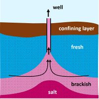
Intensive groundwater extraction can increase the intrusion of seawater into the coastal aquifer by decreasing the freshwater pressure head; this will reduce the groundwater discharge [math]Q[/math] to the sea (see Eq. 1). This intrusion is a slow process, but with a long-lasting impact. The most immediate effect of pumping up groundwater is the rise of the fresh-salt transition under the well, a phenomenon called 'saltwater upconing', see Fig. 9. When a critical limit of the extraction rate is exceeded, deeper and saltier water is extracted, and the fresh-salt transition rises up to the well mouth and the pumped water becomes brackish. The rise of the fresh-salt transition is strongest in cases where the hydraulic conductivity [math]k[/math] of the aquifer is small (low conductivity limits the horizontal groundwater flow towards the well)[15]. For aquifers with a low permeability (small [math]k[/math]), only small abstraction rates are possible.
Saline seepage
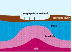
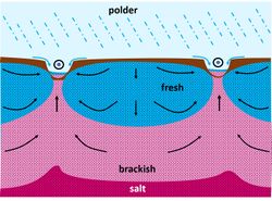
In areas situated below sea level, groundwater can move upwards to the soil surface if the upper soil layer is semipermeable, see Fig. 10 and 11. The upward moving saline seepage water may (1) discharge directly in lakes, canals, ditches or subsurface drain tiles leading to the salinization of surface waters, (2) mix near the surface with shallow fresh groundwater, or even (3) reach the root zone affecting crop growth and natural vegetation. Where rainwater or fresh surface water supplies are limited, saline seepage leads to salinization of surface water and shallow groundwater - a process known as internal salinization. The seepage flow depends on the surface soil level and on the thickness and permeability of the top soil layer (Fig. 10). Seepage flow is enhanced at places where ancient sandy deposits are close to the surface or where cracks exist in the top clay layer, giving rise to so-called 'boils' through which preferential saline seepage occurs at high fluxes[16]. Seepage in deep polders is increased when the top soil is drained for agricultural purposes, creating lower phreatic water levels (Fig. 11). Compaction of clay and peat soils is another serious consequence of drainage. The effect of seepage on seawater intrusion is similar to the effect of groundwater extraction; it causes upconing of brackish groundwater and increases the intrusion of seawater into the coastal aquifer.
Irrigation practices
In arid coastal plains where the groundwater salinity is too high, crops must be irrigated with water that is supplied from elsewhere. Due to water scarcity, the infiltrated irrigation water is collected in special drains and re-used for irrigation. Such an irrigation system exists, for example, in the Nile Delta [17]. Because the irrigation water is mixed with brackish groundwater, re-use can cause, in combination with evapotranspiration, a net salt flux to the land surface.
Groundwater management
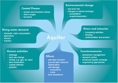
Groundwater management requires an integrated approach based on insight into the multiple factors that influence the groundwater system, see Fig. 12. This insight is usually fragmentary due to the complexity of the groundwater system. Groundwater flow models are crucial for estimating the influence of abstractions on the groundwater status, see section Groundwater modelling. Permits, metering of wells, quotas and water taxes are the legal instruments on which sustainable groundwater management can be based, together with obligations of monitoring and reporting. Polluting substances from point sources (industrial effluents, household sewage) and from diffuse sources (agricultural effluents containing pesticides, herbicides, fertilizers) are a major danger for groundwater contamination. Adequate environmental policy, agricultural policy, and spatial policy that tackle the pollution issue are prerequisite for sustainable groundwater management. The effectiveness of groundwater management can be increased by involving local stakeholders, due to the strong link between use and usability of the groundwater resource. Understanding and support from stakeholders makes it easier to enforce legal rules and provisions. Without support of stakeholders, enforcement is usually difficult to achieve [18].
Monitoring aquifers for protection against depletion and pollution is a technically demanding and costly exercise so that information about aquifers is often incomplete. The costs for setting up a monitoring network, collecting data regularly, processing, interpreting, and storing it in databases, including unified databases at the national level, are one of the reasons why in developed and developing countries alike water rights and monitoring obligations, especially with respect to groundwater, may remain unimplemented [18].
Measures to reduce soil and groundwater salinization
Different types of technical measures are possible to reduce soil and groundwater salinization, which can be applied depending on the geological setting and the causes of salt intrusion.
Horizontal wells
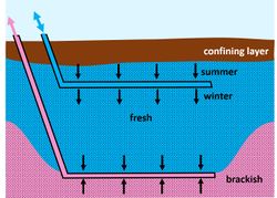
The risk of upconing of the salt-fresh interface due to groundwater exploitation can be reduced by 'skimming' the fresh water lens with a horizontal well, see Fig. 13, instead of using vertical wells. In this way it is possible to exploit a brackish aquifer with a relatively thin fresh water lens. Periodically, natural (or artificial) recharge of the fresh water lens is necessary to get the salt-fresh interface back to its former position.
Fresh water storage by artificial infiltration
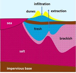
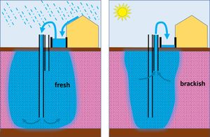
According to the principle shown in Fig. 4, a large fresh water reservoir can be created in the subsoil by raising the fresh water table. This principle can for example be applied in coastal zones protected by a dune belt, but every higher elevated area in a coastal setting could be suitable. For example, Pauw et al. (2015)[19] artificially recharged a freshwater lens below a slightly elevated sandy creek ridge following the principle of Badon-Ghyben Herzberg. By infiltrating fresh water in the dunes – rain water or fresh water from other sources – the fresh water table can be raised such that a large column of fresh water in the subsoil is kept in hydrostatic balance with the seawater, due to the small density difference (Fig. 14). Increasing the freshwater storage capacity of coastal dunes by artificial infiltration is widely used in the Netherlands to supply drinking water to coastal cities (for example, Amsterdam, The Hague).
Fresh water storage by injection
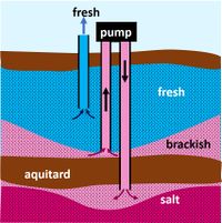
Collected rainwater – or fresh water from other sources – can temporarily be stored in the subsoil for later re-use. Fresh water is injected into the deeper part of the aquifer and collected later from a higher pumping well, as shown in Fig. 15. A larger volume of fresh water can be stored by lowering the salt-fresh interface. Salt groundwater is pumped away from greater depth to reduce the hydrostatic pressure on the surface layer. This will prevent an existing freshwater lens from being pushed out[20]. The brackish/salt water has to be discharged to the sea or it can be treated in a desalination plant for re-use[21]. The extraction-injection is adjusted by a so-called automatic 'freshmaker system'[20]. The principle is shown schematically in Fig. 16. Another option (if technically and economically feasible) is to pump the brackish/salt water through the underlying aquitard to a lower aquifer ('freshkeeper system'[20]), see Fig. 17.
Aquifer barriers to prevent seawater intrusion
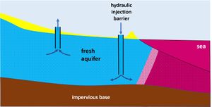
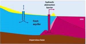
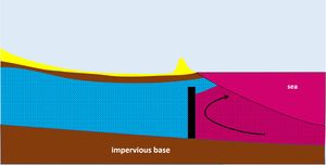
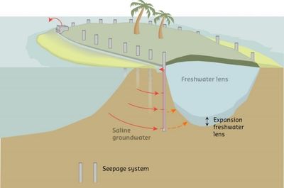
Two types of barriers have been implemented in practice: hydraulic barriers and physical barriers. The usual principle of a hydraulic barrier is shown in Fig. 18. Fresh water (for example, purified sewage water) is injected into the aquifer close to the seaward boundary to create a pressure head that prevents the intrusion of seawater. Further inland, freshwater can be extracted (to a limited extent) in periods of drought from the fresh aquifer. A practical example is the hydraulic barrier installed in California near Los Angeles [22]. The effectiveness of this solution depends on the availability of fresh water during sufficiently long and frequent periods. Another principle is based on extraction of intruding seawater, as shown in Fig. 19. Drawbacks of this principle are the disposal of the extracted saline or brackish groundwater and the lowering of the piezometric heads, especially in shallow coastal aquifers[23]. This latter issue can be mitigated by fresh water injection further landward[24]. This principle was implemented at a coastal area of the Netherlands (Perkpolder) to protect a freshwater lens from the impact of a managed realignment project[25]. This self-flowing seepage system called 'SeepCat' is thought to be also applicable for small oceanic islands to protect vulnerable underground freshwater reserves from sea level rise, climate change and overexploitation, see appendix A for a more detailed description.
Physical subsurface barriers have been constructed in several countries, especially in Japan[26] and China [27]. The barriers are generally built of concrete using grouting techniques or mixed-in-place slurry-wall methods[28]. The dams serve as a barrier for seawater intrusion, and also create underground fresh water storage in periods of strong precipitation (Fig. 20). However, the costs are high and the solution is only applicable in shallow aquifers[23].
Isolating saline areas
Saline seepage due to local boils – a major salinization mechanism in the deep polders in the Netherlands – is combated by building a bypass around the saline areas. The temporary isolation (during dry periods) of saline areas with a significant number of boils is controlled by automatic weirs[29]. The temporarily stored salt water is discharged during rainstorm events when salt concentrations are low. Boils that arise from the removal of structures, such as level filters or sheet piles, or from the sealing of old gas wells, can be sealed. This can be done through injection of expanding and persisting fluids or through biosealing; the latter option is the most environmentally friendly.
Dealing with brackish groundwater
In arid coastal zones with endemic freshwater shortages, there are no good options for preventing salt intrusion into the groundwater. Strict regulation of groundwater abstraction is necessary to make land use possible. Agriculture has to make use of salt-tolerant crops. Fortunately, ever better crops are being developed for saline conditions, including by genetic modification techniques[30][31]. In addition, infrastructure must be protected against corrosion by saline groundwater, including the use of salt-resistant concrete.
Groundwater modelling and observation
Groundwater flow can be described with Darcy's law that couples the flow rate linearly to the gradient in the hydrostatic groundwater pressure. For an introduction to groundwater flow modelling, see for example the downloadable lecture notes of Oude Essink (2000)[32]. Application of Darcy's law requires knowledge of the soil permeability (generally expressed in terms of hydraulic conductivity). The permeability is different for each soil type. The structure and composition of the substrate is generally very complex. It is a reflection of the geological history in which a large number of processes on very diverse space and time scales play a role. The reliability with which groundwater flows can be simulated therefore depends primarily on the extent to which the structure and composition of the subsoil are known. This knowledge usually has large gaps, since sampling the subsurface over great depth requires a great deal of effort and is very expensive. In addition to knowledge of the subsurface structure, knowledge is needed of the position of the salt-fresh transition zones in the underground. Missing knowledge can be partially overcome by model calibration based on data from wells (quantity and quality of abstractions), piezometric surveys (groundwater pressure) and observations based on geophysical techniques.
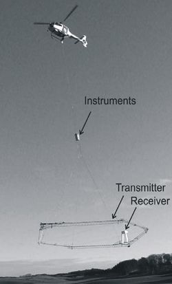
In recent decades, a large number of geophysical measurement methods have been developed that indirectly provide information about the subsurface soil structure and groundwater salinity and distribution[33]. Seismic techniques, such as Ground Penetrating Radar (GPR [34][35]) can be used for detecting and mapping structures in the underground. Unfortunately, this technique is less suitable for saturated soils with a high clay content. Nuclear Magnetic techniques, such as Magnetic Resonance Sounding (MRS [36]) and Time Lapse Gravity (TLG [37]) can provide information on aquifer properties, such as moisture content, porosity and hydraulic conductivity. Electrical resistivity (Fig. 21) and electromagnetic techniques (Fig. 22) make use of the large electrical resistivity contrast between seawater and freshwater for detecting and mapping the subsurface salinity distribution [38]. Examples are Electrical Resistivity Tomography (ERT [39]), Time-Lapse Resistivity (TLR[40]), Time Domain Electromagnetic sounding (TDEM [41]), Frequency Domain EM and Induced Polarization (IP [42]). Airborne EM (time or frequency domain) using a helicopter to acquire EM-data of the subsoil has recently showed to be very promising in mapping the fresh-salt interface of large coastal areas in The Netherlands, Germany, Denmark and Belgium[43][44]. Together with information from wells, bore holes and model calculations, these data enable reasonable estimates of the effect of interventions in the groundwater system. However, the design of groundwater models and the interpretation of model results still require highly specialized knowledge and experience of geohydrological processes.
Appendix A: The SeepCat system
SeepCat is a saline groundwater discharge system that can protect limited freshwater resources on small islands against salinization and increases the availability of freshwater. Sea levels area expected to rise up to 1 m in the next 100 years and will increase the saline groundwater pressure and therefore reduce the size of coastal freshwater lenses. The saline groundwater discharge system SeepCat is able to compensate the effects of sea level rise by lowering the salt water pressure for enlargement of the freshwater lens.
Theoretical background
Usually, there is much more space in the subsoil to store fresh water than on the surface, e.g. in basins. Also, losses by evaporation and contamination are much less when water is stored in the subsoil. However, it is difficult to increase groundwater stocks in coastal areas because of the presence of saline groundwater. The lighter fresh groundwater is pushed upward by the buoyancy force of the denser saline groundwater beneath. The thickness of the freshwater lenses in coastal areas are therefore limited. The thickness can be estimated by the theoretical relation derived by Badon-Ghyben Herzberg (BGH) (see Figs. 4 and 14). From this BGH-relation it can be derived that the thickness of a freshwater lens (in a theoretical homogeneous case) is about 40 times the groundwater level above sea level. From this relation it can also easily be seen that a freshwater lens is able to grow when: (1) the groundwater level is increased, e.g. by artificial recharge (injection system), and (2) the water pressure of the saline groundwater is reduced, in the present case by SeepCat.
Description of SeepCat
The purpose of this saline groundwater discharge system is to reduce the water pressure of the saline groundwater surrounding the freshwater lens. This is analogous to a drop of the sea level, resulting in a new equilibrium stage in which the freshwater lens is able to grow. The discharge system consists of vertical perforated tubes between the freshwater lens and the ocean side. The vertical tubes are connected to a horizontal tube with a pump. The extracted saline groundwater is discharged to the sea. A schematic diagram of the implementation of the system on an island is shown in the Fig. 23.
The SeepCat system is applied in the Netherlands (Perkpolder) to protect a freshwater lens used for irrigation from salinization caused by an adjacent 'managed realignment' project. This depoldering project for tidal flat restoration in the Western Scheldt estuary has a similar impact on the groundwater of the adjacent land as a local sea level rise of about 1.5 m. 61 vertical discharge tubes were installed over a total length of 1 km. A total of 400 m3 of saline groundwater is discharged every day. The results of this project were presented at the Salt Water Intrusion Meeting in Cairns (Australia), July 2016 [25]. For a short movie of the pilot project at Perkpolder choose 'View highlight' at [1].
Appendix B: Seawater intrusion length derivation
Here an analytical derivation is given of seawater intrusion in a highly idealized aquifer system, see Fig. B1. The aquifer is assumed horizontal and homogeneous with uniform hydraulic conductivity [math]k[/math] and depth [math]D[/math]. The horizontal distance [math]x[/math] is taken from the sea boundary [math]x=0[/math]; the tip of the intruding seawater wedge is located at [math]x=L[/math]. The depth of the fresh water column is [math]d(x)[/math]. The fresh-salt water interface is sharp, based on the assumption that the fresh water discharge [math]Q[/math] through the interface is instantaneously completed mixed with seawater. The fresh water discharge is driven by a gradient [math]dh/dx[/math] of the fresh water piezometric head [math]h(x)[/math] (also called hydraulic head). Rainwater infiltrating into the groundwater in the seawater intrusion zone is ignored, meaning that [math]Q[/math] does not depend on [math]x[/math]. It is further assumed that the pressure distribution is hydrostatic, in agreement with the Badon-Ghyben Herzerg relationship [math]d(x) + d_0= \alpha h(x) [/math] (see Fig. 1), where [math]d_0[/math] is the thickness of the confining layer and [math]\alpha \approx 40[/math].This implies
[math]\Large\frac{d}{dx}\normalsize d(x)= \alpha \Large\frac{d}{dx}\normalsize h(x) . \qquad (B1)[/math]
It is assumed that Darcy's law can be applied to the flow in the aquifer (see Fig. B1):
[math]Q = k d(x) \large\frac{d}{dx}\normalsize h(x) = \Large\frac{k}{2 \alpha} \frac{d }{dx}\normalsize (d(x))^2. \qquad (B2)[/math]
Integration yields
[math] Q \, x = \Large\frac{k}{2 \alpha Q}\normalsize (d(x))^2 \; , \quad[/math] or [math]\quad d(x) = \sqrt{\large\frac{2 \alpha Q}{k}\normalsize \, x} , \qquad (B3)[/math]
where the conditions at the seaward boundary [math]d(0)= 0[/math] has been used. If the confining layer extends below the sea, the sea boundary has to be taken where the confining layer ends.
Substitution of [math]d(L)=D[/math] at the landward tip of the seawater wedge [math]x=L[/math] yields Eq. (1).
If the piezometric head gradient [math]I=dh/dx[/math] is known, Eq. (1) simplifies to [math]L = D / (2 \alpha I)[/math]. In flat, low-lying coastal areas (e.g. river deltas), seawater can penetrate the groundwater far inland due to the low hydraulic head (see e.g. Fig. 3).
A relationship for the seawater intrusion length similar to Eq. (1) holds for shallow unconfined aquifers by replacing [math]\alpha[/math] by [math]\alpha +1[/math]. A more general treatment of groundwater flow can be found in Oude Essink (2001[45]).
Related articles
Further reading
Anderson, D.J. 2017. Coastal Groundwater and Climate Change. Water Research Laboratory, University of New South Wales, School of Civil and Environmental Engineering. WRL Technical Report 2017/04 https://coastadapt.com.au/sites/default/files/factsheets/Coastal%20groundwater%20and%20Climate%20change_final.pdf
References
- ↑ Santos, I.R., Chen, X., Lecher, A.L., Sawyer, A.H., Moosdorf, N., Rodellas, V., Tamborski, J., Cho, H-M., Dimova, N., Sugimoto, R., Bonaglia, S., Li, H., Hajati, M-C. and Li, L. 2021. Submarine groundwater discharge impacts on coastal nutrient biogeochemistry. Nat Rev Earth Environ 2: 307–323
- ↑ 2.0 2.1 Werner, A.D. and Simmons, C.T. 2009. Impact of sea-level rise on sea water intrusion in coastal aquifers. Ground Water 46(2): 197–204
- ↑ Michael, H.A., Post, V.E.A., Wilson, A.M. and. Werner, A.D. 2017. Science, society, and the coastal groundwater squeeze. Water Resour. Res. 53: 2610–2617
- ↑ pbslearningmedia https://www.pbslearningmedia.org/resource/buac17-35-sci-ess-waterdistribute/saltwater-and-freshwater-distribution-on-earth/
- ↑ WWAP (United Nations World Water Assessment Programme). 2015. The United Nations World Water Development Report 2015: Water for a Sustainable World. Paris, UNESCO https://unesdoc.unesco.org/ark:/48223/pf0000231823
- ↑ Jiao, J. and Post, V. 2019. Coastal Hydrogeology. Cambridge University Press.
- ↑ Syvitski, J. P., Kettner, A. J., Overeem, I., Hutton, E. W., Hannon, M. T., Brakenridge, G. R. and Nicholls R. J. 2009. Sinking deltas due to human activities. Nature Geoscience 2: 681-686
- ↑ Hossain, M.I., Reza, A.H.M.S., Shafiuzzaman, S.M., Sultan-Ul-Islam, M.and Rahman, M.A. 2025. The effects of seawater intrusion on sustainable coastal areas: A comprehensive study on Bagerhat district, Bangladesh. Regional Studies in Marine Science 82, 104038
- ↑ Custodio, E. and Bruggeman, G.A., editors. Groundwater problems in coastal areas: a contribution to the International Hydrological Programme. Studies and reports in hydrology, vol. 45. Paris: UNESCO; 1987
- ↑ Post, V.E.A., Eichholz, M. and Brentführer R. 2018. Groundwater management in coastal zones. Bundesanstalt für Geowissenschaften und Rohstoffe (BGR). Hannover, Germany, 107 pp.
- ↑ Van Dam, J.C. 1983. The shape and position of the salt water wedge in coastal aquifers. Proceedings of the Hamburg Symposium on Relation of Groundwater Quantity and Quality. IAHS Publ. no. 146: 59–75
- ↑ Werner, A.D., Bakker, M., Post, V.E.A., Vandenbohede, A., Lu, C., Ataie-Ashtiani, B., Simmons, C.T. and Barry, D.A. 2013. Seawater intrusion processes, investigation and management: Recent advances and future challenges. Advances in Water Resources 51: 3–26
- ↑ 13.0 13.1 Post, V.E.A., Eichholz, M. and Brentführer R. 2018. Groundwater management in coastal zones. Bundesanstalt für Geowissenschaften und Rohstoffe (BGR). Hannover, Germany, 107 pp.
- ↑ Ferguson, G. and Gleeson, T. 2012. Vulnerability of coastal aquifers to groundwater use and climate change. Nature Climate Change 2: 342–345
- ↑ Dagan G, Bear J. 1968. Solving the problem of local interface upconing in a coastal aquifer by the method of small perturbations. Journal Hydrological Research 6: 15–44
- ↑ De Louw, P.G.B., Oude Essink, G.H.P., Stuyfzand, P.J. and Van der Zee, S.E.A.T.M. 2010. Upward groundwater flow in boils as the dominant mechanism of salinization in deep polders, The Netherlands. Journal of Hydrology 394: 494-506
- ↑ Kotb, T.H.S., Watanabe, T., Ogino, Y. and Tanji, K.K. 2000. Soil salinization in the Nile Delta and related policy issues in Egypt. Agricultural Water Management 43: 239-261
- ↑ 18.0 18.1 Mechlem, K. 2016. Groundwater Governance: The Role of Legal Frameworks at the Local and National Level—Established Practice and Emerging Trends. Water 2016, 8, 347; doi:10.3390/w8080347
- ↑ Pauw, P.S., Van Baaren, E.S., Visser, M., De Louw, P.G.B. and Oude Essink, G.H.P. 2015. Increasing a freshwater lens below a sandy creek ridge using a controlled artificial recharge and drainage system: a case study in the Netherlands. Hydrogeology Journal 23: 1415–1430
- ↑ 20.0 20.1 20.2 Zuurbier, K. G., Kooiman, J. W., Groen, M. M., Maas, B. and Stuyfzand, P. J. 2014. Enabling successful aquifer storage and recovery (ASR) of freshwater using horizontal directional drilled wells (HDDWs) in coastal aquifers. In: Journal of Hydrologic Engineering 20 (3), B4014003
- ↑ Khadra, W.M., Stuyfzand, P.J. and Khadra, I.M. 2017. Mitigation of saltwater intrusion by ‘integrated fresh-keeper’ wells combined with high recovery reverse osmosis. Science of The Total Environment 574: 796-805
- ↑ Johnson, T. 2007. Technical Documents on Groundwater and Groundwater Monitoring Battling Seawater Intrusion in the Central and West Coast Basins. WRD Technical Bulletin 13.
- ↑ 23.0 23.1 Oude Essink, G.H.P. 2001. Improving fresh groundwater supply-problems and solutions. Ocean & Coastal Management 44: 429–449
- ↑ Pool, M. and Carrera, J. 2010. Dynamics of negative hydraulic barriers to prevent seawater intrusion. Hydrogeology Journal 18: 95–105
- ↑ 25.0 25.1 De Louw et al., 2016. A self-flowing seepage system to protect a freshwater lens from local sea level rise. Pages 67-70 from: Werner, A.D. (ed.), Proceedings of the 24th Salt Water Intrusion Meeting and the 4th Asia-Pacific Coastal Aquifer Management Meeting, 4-8 July, 2016, Cairns, Australia http://swim-site.nl/index.html
- ↑ Nishigaki, M., Kankam-Yeboah, K. and Komatsu, M. 2004. Underground dam technology in some parts of the world. Journal of Groundwater Hydrology 46: 113-130
- ↑ Wang, K., Li, B., Yu, Q. and Wang, J. 2012. The construction of underground reservoir and its beneficial effect on resource and environment in Shandong Province Peninsula. In: China Geological Survey – Achievements. http://en.cgs.gov.cn/achievements/201601/t20160112_35475.html
- ↑ Ishida, S., Tsuchihara, T., Yoshimoto, S. and Imaizumi, M. 2011. Sustainable use of groundwater with underground dams. In: Japan Agricultural Research Quarterly 45: 51-61
- ↑ Kamps, P., Nienhuis, P., van den Heuvel, D. and de Joode, H. 2016. Monitoring Well Optimization for Surveying the Fresh/Saline Groundwater Interface in the Amsterdam Water Supply Dunes. 24th Salt Water Intrusion Meeting and the 4th Asia-Pacific Coastal Aquifer Management Meeting, July 2016, Cairns, Australia
- ↑ De Vos, A., Bruning, B., Van Straten, G., Oosterbaan, R., Rozema, J. and Van Bodegom, P. 2016. Crop salt tolerance. Salt Farm Texel. https://www.salineagricultureworldwide.com/uploads/file_uploads/files/Report_Crop_Salt_Tolerance-Salt_Farm_Texel.pdf
- ↑ Roy, S.J., Negrao, S. and Tester, M. 2014. Salt resistant crop plants. Current Opinion in Biotechnology 26: 115–124
- ↑ Oude Essink, G.H.P. 2000. Groundwater Modelling. Lecture notes, Utrecht University. https://publicwiki.deltares.nl/display/FRESHSALT#freshsalt-download
- ↑ Herckenrath, D. 2012. Informing groundwater models with near-surface geophysical data. Thesis, Technical University of Denmark
- ↑ Knight, R. 2001. Ground penetrating radar for environmental applications. Annual Review of Earth and Planetary Sciences 29L 229-255
- ↑ Huisman, J., Hubbard, S., Redman, J. and Annan, A. 2003. Measuring Soil Water Content with Ground Penetrating Radar: A Review. Vadose Zone Journal 2: 476-491
- ↑ Legchenko, A., Baltassat, J. M., Beauce, A. and Bernard, J. 2002. Nuclear magnetic resonance as a geophysical tool for hydrogeologists. Journal of Applied Geophysics 50: 21-46
- ↑ Montgomery, E.L. 1971. Determination of coefficient of storage by use of gravity measurements: Ph.D. dissertation, University of Arizona, Tucson, 144 p
- ↑ Macaulay, S. and Mullen, I. 2007. Predicting salinity impacts of land-use change: Groundwater modelling with airborne electromagnetics and field data, SE Queensland, Australia, International Journal of Applied Earth Observation and Geoinformation 9: 124-129
- ↑ Acworth, R.I. and Dasey, G.R. 2003. Mapping of the hyporheic zone around a tidal creek using a combination of borehole logging, borehole electrical tomography and cross-creek electrical imaging, New South Wales, Australia. Hydrogeology Journal 11: 368–77
- ↑ Poulsen, S.E., Rasmussen, K.R., Christensen, N.B. and Christensen, S. 2010. Evaluating the salinity distribution of a shallow coastal aquifer by vertical multielectrode profiling (Denmark). Hydrogeology Journal 2010: 161–71
- ↑ Auken, E., Christiansen, A. V., Jacobsen, L. H. and Sorensen, K. I. 2008. A resolution study of buried valleys using laterally constrained inversion of TEM data. Journal of Applied Geophysics 65: 10-20
- ↑ Dahlin, T., Leroux, V. and Nissen, J. 2002. Measuring techniques in induced polarisation imaging. Journal of Applied Geophysics 50: 279– 298
- ↑ Siemon, B., Ibs-von Seht, M., Steuer, A., Deus, N. and Wiederhold, H. 2020. Airborne electromagnetic, magnetic, and radiometric surveys at the German North Sea Coast applied to groundwater and soil investigations. Remote Sens. 12(10), 1629, doi: 10.3390/rs12101629
- ↑ Delsman, J., Van Baaren, E.S., Siemon, B., Dabekaussen, W., Karaoulis, M.C., Pauw, P., Vermaas, T., Bootsma, H., De Louw, P.G.B., Gunnink, J.L., Dubelaar, W., Menkovic, A., Steuer, A., Meyer, U., Revil, A. and Oude Essink, G.H.P. 2018. Large-scale, probabilistic salinity mapping using airborne electromagnetics for groundwater management in Zeeland, the Netherlands. Environ. Res. Lett. 13. doi:10.1088/1748-9326/aad19e download
- ↑ Oude Essink, G.H.P. 2001. Density Dependent Groundwater Flow. Lecture notes, Utrecht University. Download from https://publicwiki.deltares.nl/display/FRESHSALT#freshsalt-download
Please note that others may also have edited the contents of this article.
|
